Difference between revisions of "2009-05-24 30 -86"
imported>Bos (New page: Easy and successful roadside expedition in the Crestview, Florida graticule. Sadly attended only by Powertool and Bos. {{meetup graticule | map=<...) |
imported>FippeBot m (Location) |
||
| (4 intermediate revisions by one other user not shown) | |||
| Line 2: | Line 2: | ||
{{meetup graticule | {{meetup graticule | ||
| − | | map=<map lat="30" lon="-86" date="2009- | + | | map=<map lat="30" lon="-86" date="2009-05-24" /> |
| lat=30 | | lat=30 | ||
| lon=-86 | | lon=-86 | ||
| − | | date=2009- | + | | date=2009-05-24 |
| − | | graticule_name= | + | | graticule_name=Crestview |
| − | | graticule_link= | + | | graticule_link=Crestview, Florida}} |
| − | }} | ||
[[Category:Expeditions]] | [[Category:Expeditions]] | ||
| Line 22: | Line 21: | ||
== Expedition Report == | == Expedition Report == | ||
| + | <!--- | ||
| + | === By [[user:Powertool|Powertool]] === | ||
| − | + | Pending--> | |
| − | + | ==== By [[User:Bos|Bos]] ==== | |
| − | + | Rendezvoused as planned and headed north to pick up a geocache enroute to the hash. Trip impeded by rain soaked clay road eroded by recent heavy rains but we prevailed. Arrived at hash point just one or two minutes late. Was pleasant surprise to see the road had been paved since the date of Google Maps imagery. Blew through the point to find suitable roadside parking a couple hundred meters beyond. Walked back for some photo documentation and the obligatory xkcd notice. Waited around hoping in vain for arrival of other revelers. | |
| − | + | Walked back to parked Potato Wagon to enjoy some iced tea and pretzels before proceeding to investigate the condition of some [http://www.geocaching.com/mark/details.aspx?PID=BG4252 National Geodetic Survey (NGS) benchmarks] and a couple more geocaches including a really fun [http://www.geocaching.com/seek/cache_details.aspx?guid=0cfb2043-d7d2-4611-bfe5-45a43a881cf7 night cache in the woods.] Had nice conversation with a lady school bus driver and her husband who wondered what we were doing. Good expedition but we missed the [[User:Liberian|Liberian]]. | |
| Line 66: | Line 67: | ||
== Photos == | == Photos == | ||
| − | + | <gallery> | |
| − | + | Image:2009-05-24_30_-86-RM3.jpg |Nearby Reference Mark - Single remaining mark of the original six set by National Geodetic Survey (NGS) at Triangulation Station Pine View, Florida | |
| + | Image:2009-05-24_30_-86-xkcd.jpg | Welcome for late arrivals. | ||
| + | </gallery> | ||
| − | <!--- | + | <!--- |
| − | |||
| − | |||
| − | |||
Image:2009-04-05_30_-86-xkcd.jpg|xkcd notice for late comers. Distance to hash 0.28 statute miles. | Image:2009-04-05_30_-86-xkcd.jpg|xkcd notice for late comers. Distance to hash 0.28 statute miles. | ||
Image:2009-04-05_30_-86-Trail.jpg | B4work and Bos slog down the soggy, soggy trail | Image:2009-04-05_30_-86-Trail.jpg | B4work and Bos slog down the soggy, soggy trail | ||
| Line 85: | Line 85: | ||
Image:2009-03-21 30 -86-IntoSettingSun.jpg|Last 1/4 mile west on paved road | Image:2009-03-21 30 -86-IntoSettingSun.jpg|Last 1/4 mile west on paved road | ||
--> | --> | ||
| + | {{location|US|FL|WL}} | ||
Latest revision as of 03:31, 8 August 2019
Easy and successful roadside expedition in the Crestview, Florida graticule. Sadly attended only by Powertool and Bos.
| Sun 24 May 2009 in Crestview: 30.7976355, -86.3838622 geohashing.info google osm bing/os kml crox |
Contents
Planning
Upon Friday morning's publication of the location Bos noted high probability of a successful meetup on the rural road a few miles east of Dorcas, FL - and a few more miles east of last March's bloody but successful meetup by Liberian, Powertool and Bos. Bos put notice of this opportunity on the the Crestview hash page and forgot about it until he got email from Powertool proposing a meet.
Bos put out the word on the local geocaching network of a 1600 CDT meet at the customary marshaling point (Tropical Smoothie in Niceville) for carpool to a 1700 meet at the published geohash point.
Expedition Report
By Bos
Rendezvoused as planned and headed north to pick up a geocache enroute to the hash. Trip impeded by rain soaked clay road eroded by recent heavy rains but we prevailed. Arrived at hash point just one or two minutes late. Was pleasant surprise to see the road had been paved since the date of Google Maps imagery. Blew through the point to find suitable roadside parking a couple hundred meters beyond. Walked back for some photo documentation and the obligatory xkcd notice. Waited around hoping in vain for arrival of other revelers.
Walked back to parked Potato Wagon to enjoy some iced tea and pretzels before proceeding to investigate the condition of some National Geodetic Survey (NGS) benchmarks and a couple more geocaches including a really fun night cache in the woods. Had nice conversation with a lady school bus driver and her husband who wondered what we were doing. Good expedition but we missed the Liberian.
Photos
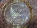
Nearby Reference Mark - Single remaining mark of the original six set by National Geodetic Survey (NGS) at Triangulation Station Pine View, Florida
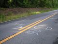
Welcome for late arrivals.

