Difference between revisions of "2009-05-27 48 8"
imported>Ekorren (gallery) |
imported>FippeBot m (Location) |
||
| (One intermediate revision by one other user not shown) | |||
| Line 13: | Line 13: | ||
== Expedition by [[User:Ekorren|Ekorren]] == | == Expedition by [[User:Ekorren|Ekorren]] == | ||
| + | This was rather close - 20 km by bike on the shortest way, and only harmless slopes. Great weather, neither heat nor rain, so there was really ''no'' excuse not to go. | ||
| + | I started around noon, went along the standard trail to Pfäffingen. There was no reason to take the fastest way, so I chose one through some hills between the common trails, crossing a small [[wikipedia:Poltringen airfield|airfield]], hitting the one or another wrong turn, and finally approaching the hash along a track called ''Grassy way''. | ||
| + | |||
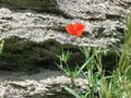
| + | At the side where I approached from, some properties were fenced, then a dense row of bushes blocked access. I half-circled the place, and found that from the other side, there was even a tractor trail leading until only a few metres from the hash, which itself was located between apple trees in high grass. There wasn't much of a view at site, as it was between some hills, not much to tell about the area either, and no reason to go into Herrenberg town this time, so - no impressions from Herrenberg section in the gallery this time. | ||
| + | |||
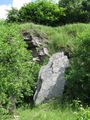
| + | Now I could just go back home through the Ammer valley, or take a more scenic route with a few additional slopes through the Schönbuch forest. I chose the latter, passed the old village of Mönchberg and went up for the mountainridge, following it to a castle ruins which I had never visitited before. That there was the final of a maximum difficulty mystery geocache conveniently located along that way, surely helped for that decision ;-). On some sign, it was labelled as ''former ruins of Müneck castle'' - which somehow got it right, because there wasn't a single stone left of the castle, just a number of moats in the forest. Oh, and a really great view down into the valley. | ||
| + | |||
| + | I also came very near to [[2009-03-08 48 8]] and took the track where I finally had given up that time... anyway, I hadn't even noted the old coordinates so there was no temptation to try and find out whether those would be accessible ''now''. Instead, I did another small detour to visit an old royal hunting lodge. It didn't really look that royal, anyway. And finally passed Bebenhausen and went home. | ||
== Gallery == | == Gallery == | ||
| Line 37: | Line 45: | ||
[[Category:Coordinates reached]] | [[Category:Coordinates reached]] | ||
[[Category:Expeditions with photos]] | [[Category:Expeditions with photos]] | ||
| + | {{location|DE|BW|BB}} | ||
Latest revision as of 03:34, 8 August 2019
| Wed 27 May 2009 in Pforzheim, Germany: 48.5941675, 8.8931014 geohashing.info google osm bing/os kml crox |
Location
In a Streuobstwiese (meadow orchard) at Herrenberg.
Expedition by Ekorren
This was rather close - 20 km by bike on the shortest way, and only harmless slopes. Great weather, neither heat nor rain, so there was really no excuse not to go.
I started around noon, went along the standard trail to Pfäffingen. There was no reason to take the fastest way, so I chose one through some hills between the common trails, crossing a small airfield, hitting the one or another wrong turn, and finally approaching the hash along a track called Grassy way.
At the side where I approached from, some properties were fenced, then a dense row of bushes blocked access. I half-circled the place, and found that from the other side, there was even a tractor trail leading until only a few metres from the hash, which itself was located between apple trees in high grass. There wasn't much of a view at site, as it was between some hills, not much to tell about the area either, and no reason to go into Herrenberg town this time, so - no impressions from Herrenberg section in the gallery this time.
Now I could just go back home through the Ammer valley, or take a more scenic route with a few additional slopes through the Schönbuch forest. I chose the latter, passed the old village of Mönchberg and went up for the mountainridge, following it to a castle ruins which I had never visitited before. That there was the final of a maximum difficulty mystery geocache conveniently located along that way, surely helped for that decision ;-). On some sign, it was labelled as former ruins of Müneck castle - which somehow got it right, because there wasn't a single stone left of the castle, just a number of moats in the forest. Oh, and a really great view down into the valley.
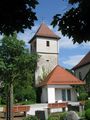
I also came very near to 2009-03-08 48 8 and took the track where I finally had given up that time... anyway, I hadn't even noted the old coordinates so there was no temptation to try and find out whether those would be accessible now. Instead, I did another small detour to visit an old royal hunting lodge. It didn't really look that royal, anyway. And finally passed Bebenhausen and went home.
Gallery
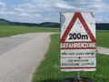
200m
DANGER ZONE
Please do not stop
Look out for approaching airplanes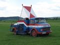
Whatever that vehicle is supposed to do...
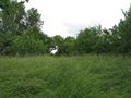
The hashpoint
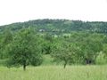
View from hash
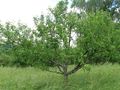
Hash tree
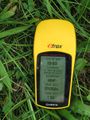
coordinates reached
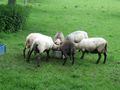
Feeding time
At Mönchberg (next village)

Disoriented spider wants to take a look on the map
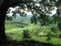
Just a view into the Ammer valley
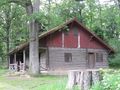
Royal Hunting Lodge, built 1888
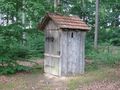
Royal Outhouse


