Difference between revisions of "2009-08-31 45 -122"
From Geohashing
imported>Jiml m (Minor update to report) |
imported>Jiml m (Add photos) |
||
| Line 22: | Line 22: | ||
I made it, and the hashpoint was accessible. Photos and more text to follow | I made it, and the hashpoint was accessible. Photos and more text to follow | ||
| − | |||
| − | |||
| − | |||
| − | |||
== Photos == | == Photos == | ||
| − | |||
| − | |||
| − | |||
| − | |||
| − | |||
<gallery perrow="3"> | <gallery perrow="3"> | ||
| − | + | Image:2009-08-31_45_-122-sign.jpg | There were a lot of these signs | |
| + | Image:2009-08-31_45_-122-Road.jpg | Roadway next to fence | ||
| + | Image:2009-08-31_45_-122-plane.jpg | One of a few planes that took off while I was walking around. | ||
| + | Image:2009-08-31_45_-122-Here.jpg | Where the GPS is | ||
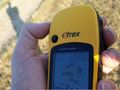
| + | Image:2009-08-31_45_-122-Zeros.jpg | Lots of a single digit on the GPS | ||
</gallery> | </gallery> | ||
| − | |||
| − | |||
| − | |||
| − | |||
| − | |||
| − | |||
| − | |||
| − | |||
| − | |||
[[Category:Coordinates reached]][[Category:Expeditions]][[Category:Expeditions with photos]] | [[Category:Coordinates reached]][[Category:Expeditions]][[Category:Expeditions with photos]] | ||
Revision as of 05:32, 2 September 2009
| Mon 31 Aug 2009 in 45,-122: 45.5465562, -122.9600685 geohashing.info google osm bing/os kml crox |
Contents
Location
In Hillsboro, Oregon, between a side street and the Hillsboro-Portland (to use the technical name) Airport. Close to the Intel end of the 25th Street.
Participants
Plans
How can I turn down a geohash this close to work?
Expedition
I made it, and the hashpoint was accessible. Photos and more text to follow
Photos
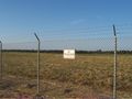
There were a lot of these signs
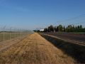
Roadway next to fence
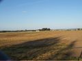
One of a few planes that took off while I was walking around.
Where the GPS is
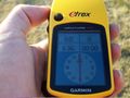
Lots of a single digit on the GPS


