Difference between revisions of "2009-08-31 45 -122"
imported>Jiml m (Add photos) |
imported>FippeBot m (Location) |
||
| (2 intermediate revisions by one other user not shown) | |||
| Line 6: | Line 6: | ||
== Location == | == Location == | ||
| − | In Hillsboro, Oregon, between a side street and the Hillsboro | + | In Hillsboro, Oregon, between a side street and the Portland-Hillsboro Aiport (to use the technical name.) |
| − | + | It is close to the Intel-Jones Farm end of the 25th Ave. | |
| Line 21: | Line 21: | ||
== Expedition == | == Expedition == | ||
| − | I | + | Well, I had a bad feeling about this hashpoint after looking at it on Google Maps and |
| + | thinking about it. The hashpoint was between a roadway and the (larger) local airport. | ||
| + | There's a fence all around the airport to keep people out, but security at airports | ||
| + | has gotten a lot more strict in the past few years. But I figured I would give it | ||
| + | at try, as I wasn't quite sure where the fence was in relation to the hashpoint. | ||
| + | So, I headed there after work, glancing at the GPS as it counted down from a couple | ||
| + | of miles to a few tenths. On the way, the airport fence disappeared behind some businesses | ||
| + | only to re-emerge. I then hit a section that I knew was just going to be roadway and fence. | ||
| + | Soon, I noticed a gate into the airport. But it also was a flat spot on the side of | ||
| + | the road to park. | ||
| + | |||
| + | So, I parked, out of the way of the gate, and walked the remaining 0.2 miles. On the way, | ||
| + | I kept expecting the GPS direction arrow to swing far to my right, sending me into chain | ||
| + | link and barbed wire. Still I walked on. | ||
| + | |||
| + | Finally, the distance closed to under 20 feet, and I looked around. | ||
| + | |||
| + | |||
| + | And I realized: The hashpoint was about 6 feet from the fence. | ||
| + | |||
| + | |||
| + | |||
| + | On my side of the fence! | ||
| + | |||
| + | |||
| + | |||
| + | The distance closed (surprisingly) to zero. Pictures were taken. Little | ||
| + | dances were done. And I thought: "So this is what urban geohashing is like." | ||
| + | |||
| + | Home and dinner of a "risotto" with lake trout called to me, and I answered. | ||
== Photos == | == Photos == | ||
| Line 34: | Line 63: | ||
</gallery> | </gallery> | ||
| + | == Achievement == | ||
| + | {{land geohash | latitude = 45 | longitude = -122 | date = 2009-08-31 | name = [[User:Jiml|Jim]] }} | ||
[[Category:Coordinates reached]][[Category:Expeditions]][[Category:Expeditions with photos]] | [[Category:Coordinates reached]][[Category:Expeditions]][[Category:Expeditions with photos]] | ||
| + | {{location|US|OR|WI}} | ||
Latest revision as of 05:31, 8 August 2019
| Mon 31 Aug 2009 in 45,-122: 45.5465562, -122.9600685 geohashing.info google osm bing/os kml crox |
Location
In Hillsboro, Oregon, between a side street and the Portland-Hillsboro Aiport (to use the technical name.) It is close to the Intel-Jones Farm end of the 25th Ave.
Participants
Plans
How can I turn down a geohash this close to work?
Expedition
Well, I had a bad feeling about this hashpoint after looking at it on Google Maps and thinking about it. The hashpoint was between a roadway and the (larger) local airport. There's a fence all around the airport to keep people out, but security at airports has gotten a lot more strict in the past few years. But I figured I would give it at try, as I wasn't quite sure where the fence was in relation to the hashpoint.
So, I headed there after work, glancing at the GPS as it counted down from a couple of miles to a few tenths. On the way, the airport fence disappeared behind some businesses only to re-emerge. I then hit a section that I knew was just going to be roadway and fence. Soon, I noticed a gate into the airport. But it also was a flat spot on the side of the road to park.
So, I parked, out of the way of the gate, and walked the remaining 0.2 miles. On the way, I kept expecting the GPS direction arrow to swing far to my right, sending me into chain link and barbed wire. Still I walked on.
Finally, the distance closed to under 20 feet, and I looked around.
And I realized: The hashpoint was about 6 feet from the fence.
On my side of the fence!
The distance closed (surprisingly) to zero. Pictures were taken. Little dances were done. And I thought: "So this is what urban geohashing is like."
Home and dinner of a "risotto" with lake trout called to me, and I answered.
Photos
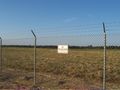
There were a lot of these signs
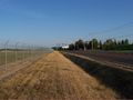
Roadway next to fence
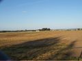
One of a few planes that took off while I was walking around.
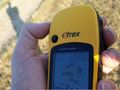
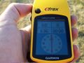
Where the GPS is
Lots of a single digit on the GPS


Achievement
Jim earned the Land geohash achievement
|