Difference between revisions of "2009-09-09 49 12"
imported>Tomcat (short report to be supplemented with more content and additional photos) |
imported>Dawidi (minor fixes, and more pictures) |
||
| Line 1: | Line 1: | ||
{{meetup graticule | {{meetup graticule | ||
| − | |||
| lat=49 | | lat=49 | ||
| lon=12 | | lon=12 | ||
| Line 7: | Line 6: | ||
| graticule_link=Regensburg, Germany}} | | graticule_link=Regensburg, Germany}} | ||
== Expedition == | == Expedition == | ||
| − | + | Today's hashpoint was on a field, already harvested and therefore accessible, 2km NNW of Wenzenbach. [[User:dawidi|dawidi]] and Tomcat went there by bike after work and arrived at the hashpoint at exactly 8:00pm. | |
| − | On their way to the hash they looked for a Geocache next to | + | On their way to the hash, they looked for a Geocache next to the cycleway (a converted railroad track) and found it despite not having the exact coordinates, but just remembering the spoiler picture. |
| − | As it was | + | As it was already dark and getting a bit cold at the hashpoint they hurried to take some photographs and left soon, heading back to Regensburg and to a late dinner before they split up. |
== Photos == | == Photos == | ||
| Line 17: | Line 16: | ||
Image:GH 2009-09-09 49 12 GPSr.jpg | coordinates reached | Image:GH 2009-09-09 49 12 GPSr.jpg | coordinates reached | ||
Image:GH 2009-09-09 49 12 dAWiDi, Tomcat.jpg | dawidi and Tomcat at the hashpoint | Image:GH 2009-09-09 49 12 dAWiDi, Tomcat.jpg | dawidi and Tomcat at the hashpoint | ||
| + | Image:2009-09-09 49 12 field north.jpg|View to the north - just a harvested field. | ||
| + | Image:2009-09-09 49 12 view west.jpg|View west/southwest. If there had been fewer trees, we might have seen some lights of Regensburg in the distance. | ||
</gallery> | </gallery> | ||
Revision as of 15:27, 26 September 2009
| Wed 9 Sep 2009 in Regensburg, Germany: 49.0945707, 12.1858268 geohashing.info google osm bing/os kml crox |
Expedition
Today's hashpoint was on a field, already harvested and therefore accessible, 2km NNW of Wenzenbach. dawidi and Tomcat went there by bike after work and arrived at the hashpoint at exactly 8:00pm.
On their way to the hash, they looked for a Geocache next to the cycleway (a converted railroad track) and found it despite not having the exact coordinates, but just remembering the spoiler picture.
As it was already dark and getting a bit cold at the hashpoint they hurried to take some photographs and left soon, heading back to Regensburg and to a late dinner before they split up.
Photos
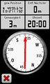
coordinates reached
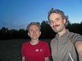
dawidi and Tomcat at the hashpoint
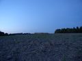
View to the north - just a harvested field.
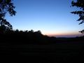
View west/southwest. If there had been fewer trees, we might have seen some lights of Regensburg in the distance.


