Difference between revisions of "2009-10-31 48 12"
imported>Dawidi (me too ;)) |
imported>FippeBot m (Location) |
||
| (3 intermediate revisions by 2 users not shown) | |||
| Line 18: | Line 18: | ||
</gallery> | </gallery> | ||
| − | == dawidi == | + | == Second expedition ([[User:dawidi|dawidi]]) == |
| − | ... was | + | I didn't have time in the afternoon, but since this hashpoint was relatively close to the next day's point, I decided to visit them both in a night expedition, getting to the second point at midnight and returning by train from Eggmühl. I had always wanted to try cycling a longer distance at night, and this seemed like a good opportunity. |
| + | |||
| + | As always, I left home much later than intended, at 22:00, and just barely made it to the ''first'' point (this one) before midnight. At 23:55, I parked my bike on the forest track near the hashpoint. I couldn't quite make out how Tomcat and Hans managed to get to the exact coordinates, since (at least according to my GPS) the hashpoint was in the middle of a thorny thicket, but I did get close enough to count it as reached as well (the GPS photo was taken on the opposite side of the thicket - I did get closer than that on the track). | ||
| + | |||
| + | I had planned to do some lightwriting too, but since I wanted to catch the train in Eggmühl at 1:07, I had to hurry, so [[2009-11-01 48 12|I continued right away]]. | ||
| + | |||
| + | <gallery> | ||
| + | Image:2009-10-31 48 12 oberndorf.jpg|Under a street light in Oberndorf, halfway to the hash. | ||
| + | Image:2009-10-31 48 12 gps.jpg|Not the closest I got... | ||
| + | Image:2009-10-31 48 12 next to hash.jpg|At the track near the hashpoint | ||
| + | Image:2009-10-31 48 12 dawidi.jpg|A tired hasher. | ||
| + | Image:2009-10-31 48 12 widi next to hash.jpg|Illuminated. | ||
| + | </gallery> | ||
| + | |||
| + | == Achievements == | ||
| + | |||
| + | {{gratuitous ribbon | ||
| + | | color = #ff8f00 | ||
| + | | icon = Halloween_geohash.gif | ||
| + | | latitude = 48 | ||
| + | | longitude = 12 | ||
| + | | date = 2009-10-31 | ||
| + | | name = Hans, Tomcat and dawidi | ||
| + | | achievement = Halloween geohash | ||
| + | | description = celebrating halloween at the | ||
| + | | image = GH_2009-10-31_48_12_lightwriting.jpg | ||
| + | }} | ||
[[Category:Expeditions]] | [[Category:Expeditions]] | ||
[[Category:Expeditions with photos]] | [[Category:Expeditions with photos]] | ||
[[Category:Coordinates reached]] | [[Category:Coordinates reached]] | ||
| + | {{location|DE|BY|KEH}} | ||
Latest revision as of 06:34, 8 August 2019
| Sat 31 Oct 2009 in Landshut, Germany: 48.8958688, 12.0324121 geohashing.info google osm bing/os kml crox |
Contents
first Halloween-Geohash in 48 12 (Hans and Tomcat)
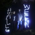
After dusk broke in on their GC-Tour to Bad Abbach, Hans and Tomcat decided to make a small detour to visit today´s 48 12-Hashpoint an do a little Halloween-Lighting there.
Hans´ and Tomcat´s Photos
Second expedition (dawidi)
I didn't have time in the afternoon, but since this hashpoint was relatively close to the next day's point, I decided to visit them both in a night expedition, getting to the second point at midnight and returning by train from Eggmühl. I had always wanted to try cycling a longer distance at night, and this seemed like a good opportunity.
As always, I left home much later than intended, at 22:00, and just barely made it to the first point (this one) before midnight. At 23:55, I parked my bike on the forest track near the hashpoint. I couldn't quite make out how Tomcat and Hans managed to get to the exact coordinates, since (at least according to my GPS) the hashpoint was in the middle of a thorny thicket, but I did get close enough to count it as reached as well (the GPS photo was taken on the opposite side of the thicket - I did get closer than that on the track).
I had planned to do some lightwriting too, but since I wanted to catch the train in Eggmühl at 1:07, I had to hurry, so I continued right away.
Achievements
Hans, Tomcat and dawidi earned the Halloween geohash
|


