Difference between revisions of "2009-11-06 39 -86"
imported>ErWenn (New page: {{subst:Expedition |lat = 39 |lon = -86 |date = 2009-11-06 }}) |
imported>FippeBot m (Location) |
||
| (6 intermediate revisions by 2 users not shown) | |||
| Line 1: | Line 1: | ||
| − | |||
<!-- If you did not specify these parameters in the template, please substitute appropriate things for IMAGE, LAT, LON, and DATE (YYYY-MM-DD format) --> | <!-- If you did not specify these parameters in the template, please substitute appropriate things for IMAGE, LAT, LON, and DATE (YYYY-MM-DD format) --> | ||
<!-- | <!-- | ||
| Line 13: | Line 12: | ||
__NOTOC__ | __NOTOC__ | ||
== Location == | == Location == | ||
| − | + | About a mile north of Lake Monroe near Moore Creek. | |
== Participants == | == Participants == | ||
| − | + | [[User:ErWenn|Erik]], Kira, and Duncan. | |
| − | |||
| − | |||
| − | |||
== Expedition == | == Expedition == | ||
| + | The hash looked accessible, about a hundred feet off of Moores Creek Road, so we went for it. If I (Erik) had looked at a map instead of just the satellite photos, I would have realized that it was practically sitting in Moore Creek. (Notice how the creek is just "Moore Creek", but the road is "Moore<strong>s</strong> Creek"? Ah, naming conventions.) Duncan was a little wary about the leaves covering the ground, but eventually he warmed up to it and became his usual straining-at-the-end-of-his-leash-if-you-pause-for-more-than-five-seconds self. The creek was so shallow, that I thought it might be a good candidate for the [[Walking on water geohash achievement]]. I'll post to the talk pages there to see if it counts as enough water. I mean it is a body of water that shows up on maps (if only as a thin blue line)... Within the margin of error of my GPS receiver, there were spots that were probably ankle-deep, parts that were completely dry, and parts that were about half a centimeter deep (which is where I'm standing in the picture below). | ||
| + | We also attempted a nearby (0.9 miles) [[Hash collision achievement|geocache]], but it got too dark, so we had to give up. | ||
| − | == | + | == Photos == |
| − | |||
| − | |||
| − | |||
| − | |||
| − | |||
| − | |||
<gallery perrow="4"> | <gallery perrow="4"> | ||
| + | Image:2009-09-06 39 -86 proof.jpg | Proof! | ||
| + | Image:2009-09-06 39 -86 Duncan.jpg | Duncan attempts the Walking on Water achievement | ||
| + | Image:2009-09-06 39 -86 Kira.jpg | Kira and Duncan near the hash | ||
| + | Image:2009-09-06 39 -86 Erik.jpg | Erik attempts the Walking on Water achievement | ||
| + | </gallery> | ||
| + | |||
| − | |||
| − | |||
| − | |||
| − | |||
| − | |||
| − | |||
[[Category:Expeditions]] | [[Category:Expeditions]] | ||
| − | |||
[[Category:Expeditions with photos]] | [[Category:Expeditions with photos]] | ||
| − | |||
| − | |||
| − | |||
| − | |||
| − | |||
[[Category:Coordinates reached]] | [[Category:Coordinates reached]] | ||
| − | + | [[Category:Meetup on 2009-11-06]] | |
| − | + | [[Category:Meetup in 39 -86]] | |
| − | + | [[Category:Expeditions with dogs]] | |
| − | + | {{location|US|IN|MR}} | |
| − | |||
| − | [[Category: | ||
| − | |||
| − | [[Category: | ||
| − | [[Category: | ||
| − | |||
Latest revision as of 06:41, 8 August 2019
| Fri 6 Nov 2009 in 39,-86: 39.1107714, -86.4648176 geohashing.info google osm bing/os kml crox |
Location
About a mile north of Lake Monroe near Moore Creek.
Participants
Erik, Kira, and Duncan.
Expedition
The hash looked accessible, about a hundred feet off of Moores Creek Road, so we went for it. If I (Erik) had looked at a map instead of just the satellite photos, I would have realized that it was practically sitting in Moore Creek. (Notice how the creek is just "Moore Creek", but the road is "Moores Creek"? Ah, naming conventions.) Duncan was a little wary about the leaves covering the ground, but eventually he warmed up to it and became his usual straining-at-the-end-of-his-leash-if-you-pause-for-more-than-five-seconds self. The creek was so shallow, that I thought it might be a good candidate for the Walking on water geohash achievement. I'll post to the talk pages there to see if it counts as enough water. I mean it is a body of water that shows up on maps (if only as a thin blue line)... Within the margin of error of my GPS receiver, there were spots that were probably ankle-deep, parts that were completely dry, and parts that were about half a centimeter deep (which is where I'm standing in the picture below).
We also attempted a nearby (0.9 miles) geocache, but it got too dark, so we had to give up.
Photos
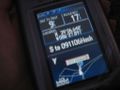
Proof!
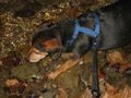
Duncan attempts the Walking on Water achievement

Kira and Duncan near the hash

Erik attempts the Walking on Water achievement


