Difference between revisions of "Israel"
imported>Yerushalmi (→Most recent hashes from the standard graticules) |
imported>Yerushalmi (→Past expeditions in Israel) |
||
| Line 21: | Line 21: | ||
* [[2008-07-28 31 35|July 28, 2008]]: Alternative location cheat in [[Jerusalem, Israel|Jerusalem]] by [[User:Lady Pennywhistle|Lady Pennywhistle]]. | * [[2008-07-28 31 35|July 28, 2008]]: Alternative location cheat in [[Jerusalem, Israel|Jerusalem]] by [[User:Lady Pennywhistle|Lady Pennywhistle]]. | ||
* [[2009-03-17 31 34|March 17, 2009]]: [[User:Yerushalmi|Yerushalmi]] and his wife successfully reached the [[Beersheba, Israel|Beersheba graticule's]] hash point in Kfar Truman. | * [[2009-03-17 31 34|March 17, 2009]]: [[User:Yerushalmi|Yerushalmi]] and his wife successfully reached the [[Beersheba, Israel|Beersheba graticule's]] hash point in Kfar Truman. | ||
| − | + | * [[2009-04-10 31 34|April 10, 2009]]: [[User:Yerushalmi|Yerushalmi]] and his wife reached the [[Beersheba, Israel|Beersheba graticule's]] hash point near Kfar Bin Nun. | |
| + | * [[2009-04-13 32 34|April 13, 2009]]: [[User:Yerushalmi|Yerushalmi]] and his wife didn't even try to reach the [[Tel-Aviv (Goosh Dan), Israel|Tel Aviv graticule's]] hashpoint, but somehow came close anyway. | ||
== Graticules and Participants == | == Graticules and Participants == | ||
Revision as of 14:10, 14 April 2009

Israel is a small country, divided between nine graticules from (29,34) to (33,35). The graticules that encompass its major population centers each have their own problems: some are almost entirely in the Mediterranean Sea, others include much of the disputed territories, and still others contain a truly staggering amount of desert. Some even contain all three. Almost all of them include some area in neighboring countries of varying degrees of unfriendliness.
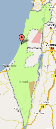
As a result, some Israelis may prefer to use an alternative algorithm, which defines a polygon including the entire state of Israel so that all Israelis share the same meeting point. An implementation of the algorithm can be found here; red zones define areas that are deemed too dangerous to access. (Geohashers are encouraged to edit the red zones to help other geohashers avoid IDF fire zones, hostile settlements, etc.) In order to calculate safe points that fall within the green zone, but outside of the red zones, the algorithm uses the previous day's exchange rates, as issued by the Bank of Israel.
Important:
- You cannot claim achievements for reaching the alternative algorithm's point. It is solely used for the purpose of arranging meetups.
- If you are planning an expedition, make sure you announce it well in advance so that other geohashers will know where you are going. It's not very helpful if one geohasher is attending a standard graticule point while another is attending the alternate graticule point, especially if both are reachable on a given day!
Contents
Most recent hashes from the standard graticules
- April 6: The Beersheba point is in what looks like an open lot off of Paris Street, Sderot.
- April 7: The Beersheba point is in the desert outside moshav Talmei Yosef. The Jerusalem point is in the Dead Sea, if anybody wants to grab a Lowest Geohash, Water Geohash, and Walk on Water Geohash all at once!
- April 8: No reachable points, unless you plan on wandering through the desert near Masada.
Most recent hashes from the alternative graticule
Past expeditions in Israel
- May 28, 2008: Haifa East graticule point was unsuccessfully reached by Ynor
- July 28, 2008: Alternative location cheat in Jerusalem by Lady Pennywhistle.
- March 17, 2009: Yerushalmi and his wife successfully reached the Beersheba graticule's hash point in Kfar Truman.
- April 10, 2009: Yerushalmi and his wife reached the Beersheba graticule's hash point near Kfar Bin Nun.
- April 13, 2009: Yerushalmi and his wife didn't even try to reach the Tel Aviv graticule's hashpoint, but somehow came close anyway.
Graticules and Participants
Those are the geohash graticules in Israel, plus current users:
- Jerusalem, Israel
- Lady Pennywhistle lives in French Hill, Jerusalem
- Yerushalmi and his wife
- Tel-Aviv (Goosh Dan), Israel
- Dor
- Vyath
- Improbable
- Eyal
- Bryan A (Moving to this graticule in July)
- Avish
- pseudoDust
- Haifa East, Israel
- Beersheba, Israel
Any other users: Don't just lurk! Add yourselves to the wiki pages, so we can know who's participating and try to arrange meetups!