Difference between revisions of "2010-01-02 45 -122"
imported>Jiml (Expand Template) |
imported>FippeBot m (Location) |
||
| (3 intermediate revisions by one other user not shown) | |||
| Line 1: | Line 1: | ||
| − | |||
| − | |||
| − | |||
| − | |||
| − | |||
| − | |||
| − | |||
{{meetup graticule | {{meetup graticule | ||
| lat=45 | | lat=45 | ||
| Line 15: | Line 8: | ||
__NOTOC__ | __NOTOC__ | ||
== Location == | == Location == | ||
| − | + | On the edge of a vinyard near Sherwood, Oregon. | |
== Participants == | == Participants == | ||
| + | * [[User:Jiml|Jim]] | ||
== Plans == | == Plans == | ||
| + | I printed out a Google map, and programmed the GPS. | ||
| + | == Expedition == | ||
| − | + | I set out to go by the hashpoint and then go run some errands. Google seemed to think I should go over | |
| + | the mountain, but I didn't think that was the best way. ("Yes, the speed limit is 55 mph, but I don't think we'll be doing that around all the hairpin turns...") I attempted to go the other way around to | ||
| + | get there, but found that I never saw the cross street as I arrived in downtown Sherwood. | ||
| + | So, I backtracked and followed Google's directions and found myself at the dead-end private road | ||
| + | that leads to the hashpoint. Either my GPS unit is getting unhappy or the overcast clouds were | ||
| + | interfering with the GPS signal, because my readings were all over the map. (I had this problem in Boston | ||
| + | when I was geocaching as well.) I finally got to | ||
| + | about 7 feet from the hashpoint and decided I had made it. I was just on the side of the road, so | ||
| + | I didn't need to go get permission to climb through the wires and go into the (slumbering) vinyard. | ||
| − | + | I waited around for anyone else to show up, but since two other Portland geohashers I had talked | |
| + | to had demurred, I figured I'd be alone. I headed back to home but stopped to look at another | ||
| + | rural Oregon graveyard. Maybe that should be a calendar theme? ("Graveyards of Washington County"?) | ||
| + | {{land geohash | latitude = 45 | longitude = -122 | date = 2010-01-02 | name = [[User:Jiml|Jim]] }} | ||
== Photos == | == Photos == | ||
| − | |||
<gallery perrow="4"> | <gallery perrow="4"> | ||
| − | Image: | + | |
| − | Image: | + | Image:2010-01-02_45_-122-entrance.jpg | The road I came on |
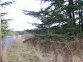
| + | Image:2010-01-02_45_-122-vineyard.jpg | A view of the hashpoint | ||
| + | Image:2010-01-02_45_-122-GPS.jpg | The GPS after wandering around the hashpoint | ||
| + | Image:2010-01-02_45_-122-more-vineyard.jpg.jpg | Another view of the vineyard | ||
| + | Image:2010-01-02_45_-122-neighbor.jpg | The area was pretty rural | ||
| + | Image:2010-01-02_45_-122-graveyard2.jpg | The latest graveyard I ran into | ||
</gallery> | </gallery> | ||
| − | |||
| − | |||
| − | |||
| − | |||
| − | |||
| − | |||
| − | |||
| − | |||
[[Category:Expeditions]] | [[Category:Expeditions]] | ||
| − | + | [[Category:Expeditions with photos]] | |
| − | [[Category:Expeditions with photos]] | ||
| − | |||
| − | |||
| − | |||
| − | |||
| − | |||
[[Category:Coordinates reached]] | [[Category:Coordinates reached]] | ||
| − | + | {{location|US|OR|WI}} | |
| − | |||
| − | |||
| − | |||
| − | |||
| − | |||
| − | |||
| − | |||
| − | |||
| − | |||
Latest revision as of 00:22, 9 August 2019
| Sat 2 Jan 2010 in 45,-122: 45.3444998, -122.9069854 geohashing.info google osm bing/os kml crox |
Location
On the edge of a vinyard near Sherwood, Oregon.
Participants
Plans
I printed out a Google map, and programmed the GPS.
Expedition
I set out to go by the hashpoint and then go run some errands. Google seemed to think I should go over the mountain, but I didn't think that was the best way. ("Yes, the speed limit is 55 mph, but I don't think we'll be doing that around all the hairpin turns...") I attempted to go the other way around to get there, but found that I never saw the cross street as I arrived in downtown Sherwood.
So, I backtracked and followed Google's directions and found myself at the dead-end private road that leads to the hashpoint. Either my GPS unit is getting unhappy or the overcast clouds were interfering with the GPS signal, because my readings were all over the map. (I had this problem in Boston when I was geocaching as well.) I finally got to about 7 feet from the hashpoint and decided I had made it. I was just on the side of the road, so I didn't need to go get permission to climb through the wires and go into the (slumbering) vinyard.
I waited around for anyone else to show up, but since two other Portland geohashers I had talked to had demurred, I figured I'd be alone. I headed back to home but stopped to look at another rural Oregon graveyard. Maybe that should be a calendar theme? ("Graveyards of Washington County"?)
Jim earned the Land geohash achievement
|
Photos
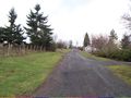
The road I came on
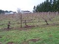
A view of the hashpoint
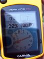
The GPS after wandering around the hashpoint
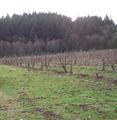
Another view of the vineyard
The area was pretty rural
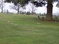
The latest graveyard I ran into


