Difference between revisions of "2010-01-13 40 -89"
From Geohashing
imported>Dvdllr |
imported>Dvdllr (→Plans) |
||
| Line 12: | Line 12: | ||
== Plans == | == Plans == | ||
| − | + | This adventure required very minor planning. Since it was right in the middle of an interstate highway, all I needed was to plan the route to pass overtop of it. Some minor modifications made sure the route didn't cross itself, and then: ready to go! | |
== Expedition == | == Expedition == | ||
Revision as of 04:50, 14 January 2010
| Wed 13 Jan 2010 in 40,-89: 40.3218086, -89.4540040 geohashing.info google osm bing/os kml crox |
Location
Interstate 155 northbound, near county road 2800 N
Participants
Dvdllr, Rachel and Marvin
Plans
This adventure required very minor planning. Since it was right in the middle of an interstate highway, all I needed was to plan the route to pass overtop of it. Some minor modifications made sure the route didn't cross itself, and then: ready to go!
Expedition
Will update later!
Photos

A familiar arrangement
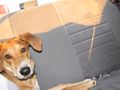
Marvin the pooch
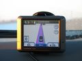
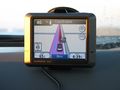
Almost there...
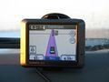
Almost there...
Bingo


Achievements
Dvdllr earned the Land geohash achievement
|

Dvdllr earned the Speed racer achievement
by passing through the (40, -89) geohash on 2010-01-13 at 65 mph.
Dvdllr earned the Tron achievement
|