Difference between revisions of "2010-01-21 48 7"
imported>Fivetonsofflax m (moved 2010-01-12 48 7 to 2010-01-21 48 7: Typo) |
imported>FippeBot m (Location) |
||
| (5 intermediate revisions by one other user not shown) | |||
| Line 16: | Line 16: | ||
I'll get out of uni at 10:45, will take the train from Heidelberg at 11:38, arrive in Wissembourg at 13:28. Will walk from there. | I'll get out of uni at 10:45, will take the train from Heidelberg at 11:38, arrive in Wissembourg at 13:28. Will walk from there. | ||
| + | |||
| + | |||
| + | == Expedition == | ||
| + | |||
| + | This was not an easy expedition. The OpenStreetMap coverage for this area is only mediocre, so GpsMid told me to just follow the country lane. Since it's a hassle to step away from the road every time a car approaches, I wanted to avoid that as far as possible, so I had to find the dirt tracks myself. They weren't comfortable to walk on either. Most of the snow from the winter had molten, so the paths were very muddy. I didn't see much of the beautiful Alsatian landscape either. It was foggy all the time and I usually couldn't see farther than 200 meters or so. | ||
| + | |||
| + | On my way, I spotted several remnants from past wars between France and Germany, such as memorials and old bunkers. The [http://en.wikipedia.org/wiki/Maginot_line Maginot Line] is very close to the hashpoint location. In fact, the fortification depicted on top of the wiki page was only 3 km away from the hashpoint. Since I wanted to get back to Wissembourg before it got dark, I didn't have any time to pay it a visit. | ||
| + | |||
| + | The hashpoint itself was on a muddy field. Since there were no plants to be seen and I only had to walk a short distance into the field, I suppose it was no trouble entering it. On my way back, I had to hurry because it started raining and the batteries of my cell phone were running low. I reached Wissembourg a few minutes after the train I had originally planned to take had departed, so at least I had some time to go to a supermarket and get something to eat. I needed that after the long walk. | ||
| + | |||
| + | On my way back to Heidelberg, I had to change to another train in Neustadt. While I was waiting for it to depart, there suddenly was a loud bang and blue sparks could be seen outside the window. A few minutes later, the lights went out and the conductor asked the passengers not to panic, get out and wait for the next train. All in all, I needed more than eight hours for this expedition. I think that's a new record for me :) | ||
| + | |||
| + | == Photos == | ||
| + | |||
| + | <gallery> | ||
| + | File:2010-01-21 48 7 01.JPG|Wissembourg station, [[2010-01-16 49 7|once again]] | ||
| + | File:2010-01-21 48 7 02.JPG|Leaving Wissembourg | ||
| + | File:2010-01-21 48 7 03.JPG|The last patches of snow | ||
| + | File:2010-01-21 48 7 04.JPG|Where will you lead me, muddy path of muddiness? | ||
| + | File:2010-01-21 48 7 05.JPG|Spooky | ||
| + | File:2010-01-21 48 7 06.JPG|German war memorial; Siege of Paris and Battle of Mont Valérien | ||
| + | File:2010-01-21 48 7 07.JPG| | ||
| + | File:2010-01-21 48 7 08.JPG|Old bunker, part of the Maginot Line | ||
| + | File:2010-01-21 48 7 09.JPG|Riedseltz, misty | ||
| + | File:2010-01-21 48 7 10.JPG|Approaching the hashpoint (outside the enclosure, fortunately) | ||
| + | File:2010-01-21 48 7 11.JPG|View from the hashpoint | ||
| + | File:2010-01-21 48 7 12.JPG|Happy hasher | ||
| + | File:2010-01-21 48 7 13.JPG| | ||
| + | File:2010-01-21 48 7 14.JPG|Muddy feet are muddy | ||
| + | File:2010-01-21 48 7 15.JPG|Riedseltz | ||
| + | File:2010-01-21 48 7 16.JPG|Dying snowman | ||
| + | File:2010-01-21 48 7 17.JPG|Another memorial at the place of a castle that was destroyed by the Germans in 1940 | ||
| + | File:2010-01-21 48 7 18.JPG|Le coq gaulois | ||
| + | </gallery> | ||
| + | |||
| + | == Tracklog with geotagged pictures == | ||
| + | |||
| + | http://www.everytrail.com/view_trip.php?trip_id=476169 | ||
| + | |||
| + | == Achievements == | ||
| + | |||
| + | {{Minesweeper geohash | ||
| + | | graticule = Mannheim, Germany | ||
| + | | ranknumber = 3 | ||
| + | | w = true | ||
| + | | e = true | ||
| + | | sw = true | ||
| + | | name = [[User:fivetonsofflax|fivetonsofflax]] | ||
| + | }} | ||
| + | |||
| + | [[Category:Coordinates reached]] | ||
| + | [[Category:Expeditions]] | ||
| + | {{location|FR|67}} | ||
Latest revision as of 00:34, 9 August 2019
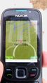
| Thu 21 Jan 2010 in 48,7: 48.9842592, 7.9407693 geohashing.info google osm bing/os kml crox |
Contents
Location
On a field near Riedseltz.
Participants
Plans
I'll get out of uni at 10:45, will take the train from Heidelberg at 11:38, arrive in Wissembourg at 13:28. Will walk from there.
Expedition
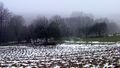
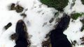
This was not an easy expedition. The OpenStreetMap coverage for this area is only mediocre, so GpsMid told me to just follow the country lane. Since it's a hassle to step away from the road every time a car approaches, I wanted to avoid that as far as possible, so I had to find the dirt tracks myself. They weren't comfortable to walk on either. Most of the snow from the winter had molten, so the paths were very muddy. I didn't see much of the beautiful Alsatian landscape either. It was foggy all the time and I usually couldn't see farther than 200 meters or so.
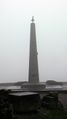
On my way, I spotted several remnants from past wars between France and Germany, such as memorials and old bunkers. The Maginot Line is very close to the hashpoint location. In fact, the fortification depicted on top of the wiki page was only 3 km away from the hashpoint. Since I wanted to get back to Wissembourg before it got dark, I didn't have any time to pay it a visit.
The hashpoint itself was on a muddy field. Since there were no plants to be seen and I only had to walk a short distance into the field, I suppose it was no trouble entering it. On my way back, I had to hurry because it started raining and the batteries of my cell phone were running low. I reached Wissembourg a few minutes after the train I had originally planned to take had departed, so at least I had some time to go to a supermarket and get something to eat. I needed that after the long walk.
On my way back to Heidelberg, I had to change to another train in Neustadt. While I was waiting for it to depart, there suddenly was a loud bang and blue sparks could be seen outside the window. A few minutes later, the lights went out and the conductor asked the passengers not to panic, get out and wait for the next train. All in all, I needed more than eight hours for this expedition. I think that's a new record for me :)
Photos
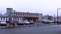
Wissembourg station, once again
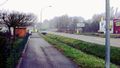
Leaving Wissembourg
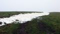
The last patches of snow
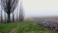
Where will you lead me, muddy path of muddiness?
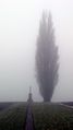
Spooky
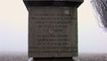
German war memorial; Siege of Paris and Battle of Mont Valérien

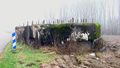
Old bunker, part of the Maginot Line
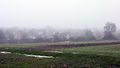
Riedseltz, misty
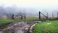
Approaching the hashpoint (outside the enclosure, fortunately)
View from the hashpoint

Happy hasher
Muddy feet are muddy
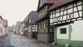
Riedseltz
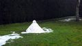
Dying snowman
Another memorial at the place of a castle that was destroyed by the Germans in 1940

Le coq gaulois


Tracklog with geotagged pictures
http://www.everytrail.com/view_trip.php?trip_id=476169
Achievements
fivetonsofflax achieved level 3 of the Minesweeper Geohash achievement
|