Difference between revisions of "2010-01-22 48 12"
imported>Dawidi (writeup + photos) |
imported>FippeBot m (Location) |
||
| Line 22: | Line 22: | ||
[[Category:Expeditions with photos]] | [[Category:Expeditions with photos]] | ||
[[Category:Coordinates reached]] | [[Category:Coordinates reached]] | ||
| + | {{location|DE|BY|R}} | ||
Latest revision as of 00:34, 9 August 2019
| Fri 22 Jan 2010 in Landshut, Germany: 48.9603168, 12.1108911 geohashing.info google osm bing/os kml crox |
In a snowy field north of Neudorf, about 10km south of Regensburg.
Tomcat, Hans and dawidi
We started off shortly after 18:00, going by car to Oberisling. There were a couple of new geocaches spread around in the area which we wanted to go find, so we took a few walks over icy field tracks. We actually found each one quite quickly and had nice views of Regensburg's lights on the horizon.
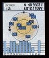
The geohash itself was next to a track a few kilometers further south and easy to reach. dawidi took a 360° long-exposure panorama there. The different light colors seen on the cloud layer are pretty close to what it really looked like. Once again, it was pretty cold so we didn't stay longer than necessary and drove back to Regensburg (with just one more geocache along the way) where we ended the expedition with two sizable, tasty pizzas near dawidi's place.


