Difference between revisions of "2010-04-19 40 -89"
imported>Dvdllr (Created page with '{{subst:Expedition |lat = 40 |lon = -89 |date = 2010-04-19 }}') |
imported>FippeBot m (Location) |
||
| (5 intermediate revisions by one other user not shown) | |||
| Line 1: | Line 1: | ||
| − | + | __NOTOC__ | |
| − | |||
| − | |||
| − | |||
| − | |||
| − | |||
| − | |||
{{meetup graticule | {{meetup graticule | ||
| lat=40 | | lat=40 | ||
| Line 11: | Line 5: | ||
| date=2010-04-19 | | date=2010-04-19 | ||
}} | }} | ||
| − | |||
| − | |||
| − | |||
== Location == | == Location == | ||
| − | + | North Knoxville Avenue, northbound, just past Orchard Place in Peoria, Illinois | |
== Participants == | == Participants == | ||
| − | + | * [[User:Dvdllr|Dvdllr]] | |
== Plans == | == Plans == | ||
| − | + | I needed to go to Peoria Monday evening, and by happenstance, my destination was a whopping 600 feet from the day's geohash location. Before going to my ultimate rendezvous, I decided to leave a little early to do a little geohashing. Since it was on the road, I didn't require a whole lot of preparation besides the camera, GPS, and the coordinates. | |
== Expedition == | == Expedition == | ||
| − | + | Immediately prior to reaching the geohash, I had been at Lowe's in East Peoria, which you can see if you look at the tracklog. (Talking of which, when I open up the tracklog, I see a straight line from where I turned off the GPS in Peoria back to where I started in East Peoria, thus looping my route. Disregard that!) Since it was just me in the car, I wasn't about to take pictures or anything while driving, so I just took video with my camera to show me driving through the location. I noticed while I was doing this that the GPS indicated that the speed limit was 45, but I had seen a sign indicating that it was actually 35. I'm guessing that the GPS was wrong, so I believe I was actually going the speed limit! (with regard to the Speed Racer geohash). I turned off Knoxville a couple of blocks later, and after driving through the labyrinthine sideroads of Peoria, I stopped on Orchard Place near where it intersects with Knoxville. I walked to the sidewalk that goes along the road to match my latitude with the geohash spot, though I wasn't about to venture out into the thoroughfare with the traffic and such. And with that, my expedition came to a close. | |
== Tracklog == | == Tracklog == | ||
| − | + | [http://www.mapmyride.com/route/us/il/peoria/805127177458140439 Link] | |
| − | == Photos == | + | == Photos == |
| − | |||
| − | |||
| − | |||
<gallery perrow="4"> | <gallery perrow="4"> | ||
| + | Image:2010-04-19 40 -89 1.jpg | From my parting spot, Knoxville Ave that I had just driven through | ||
| + | Image:2010-04-19 40 -89 2.jpg | Record of time and date | ||
| + | Image:2010-04-19 40 -89 3.jpg | GPS view from the adjacent sidewalk | ||
| + | Image:2010-04-19 40 -89 4.jpg | Right there! | ||
</gallery> | </gallery> | ||
| + | == Video == | ||
| + | [http://www.youtube.com/watch?v=noeIDqvK2zk Link] | ||
| + | |||
| + | In case you're curious, I was listening to ''The Dave Ramsey Show''. | ||
| − | + | == Achievements == | |
| − | + | {{#vardefine:ribbonwidth|800px}} | |
| − | [[ | + | {{land geohash |
| + | |||
| + | | latitude = 40 | ||
| + | | longitude = -89 | ||
| + | | date = 2010-04-19 | ||
| + | | name = [[User:Dvdllr|Dvdllr]] | ||
| + | }} | ||
| + | {{Speed racer | ||
| − | + | | latitude = 40 | |
| − | + | | longitude = -89 | |
| − | [[ | + | | date = 2010-04-19 |
| − | + | | name = [[User:Dvdllr|Dvdllr]] | |
| + | | speed = 35 mph | ||
| + | }} | ||
| + | {{A Tale of Two Hashes challenge | ||
| + | | latitude = 40 | ||
| + | | longitude = -89 | ||
| + | | date = 2010-04-19 | ||
| + | | name = [[User:Dvdllr|Dvdllr]] | ||
| + | | place = [http://en.wikipedia.org/wiki/List_of_places_named_Peoria Peoria] | ||
| + | }} | ||
| − | |||
[[Category:Expeditions]] | [[Category:Expeditions]] | ||
| − | |||
[[Category:Expeditions with photos]] | [[Category:Expeditions with photos]] | ||
[[Category:Expeditions with videos]] | [[Category:Expeditions with videos]] | ||
| − | |||
| − | |||
| − | |||
| − | |||
[[Category:Coordinates reached]] | [[Category:Coordinates reached]] | ||
| − | + | {{location|US|IL|PI}} | |
| − | |||
| − | |||
| − | |||
| − | |||
| − | |||
| − | |||
| − | |||
| − | |||
| − | |||
Latest revision as of 01:40, 9 August 2019
| Mon 19 Apr 2010 in 40,-89: 40.7294722, -89.5935139 geohashing.info google osm bing/os kml crox |
Location
North Knoxville Avenue, northbound, just past Orchard Place in Peoria, Illinois
Participants
Plans
I needed to go to Peoria Monday evening, and by happenstance, my destination was a whopping 600 feet from the day's geohash location. Before going to my ultimate rendezvous, I decided to leave a little early to do a little geohashing. Since it was on the road, I didn't require a whole lot of preparation besides the camera, GPS, and the coordinates.
Expedition
Immediately prior to reaching the geohash, I had been at Lowe's in East Peoria, which you can see if you look at the tracklog. (Talking of which, when I open up the tracklog, I see a straight line from where I turned off the GPS in Peoria back to where I started in East Peoria, thus looping my route. Disregard that!) Since it was just me in the car, I wasn't about to take pictures or anything while driving, so I just took video with my camera to show me driving through the location. I noticed while I was doing this that the GPS indicated that the speed limit was 45, but I had seen a sign indicating that it was actually 35. I'm guessing that the GPS was wrong, so I believe I was actually going the speed limit! (with regard to the Speed Racer geohash). I turned off Knoxville a couple of blocks later, and after driving through the labyrinthine sideroads of Peoria, I stopped on Orchard Place near where it intersects with Knoxville. I walked to the sidewalk that goes along the road to match my latitude with the geohash spot, though I wasn't about to venture out into the thoroughfare with the traffic and such. And with that, my expedition came to a close.
Tracklog
Photos
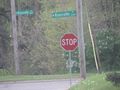
From my parting spot, Knoxville Ave that I had just driven through
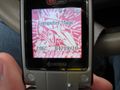
Record of time and date
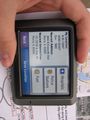
GPS view from the adjacent sidewalk

Right there!


Video
In case you're curious, I was listening to The Dave Ramsey Show.
Achievements
Dvdllr earned the Land geohash achievement
|
Dvdllr earned the Speed racer achievement
|
Dvdllr issued a challenge for the Tale of Two Hashes achievement
|