Difference between revisions of "2010-05-05 44 4"
From Geohashing
imported>Relet (→Expedition) |
imported>Lyx m (→Photos) |
||
| Line 45: | Line 45: | ||
File:2010-05-05-44-4-P1060018.JPG | Approach road | File:2010-05-05-44-4-P1060018.JPG | Approach road | ||
File:2010-05-05-44-4-P1060019.JPG | A dry riverbed we would get to know better | File:2010-05-05-44-4-P1060019.JPG | A dry riverbed we would get to know better | ||
| − | File:2010-05-05-44-4- | + | File:2010-05-05-44-4-P1060021.JPG | There were footpaths... still. |
File:2010-05-05-44-4-P1060022.JPG | And stairs! | File:2010-05-05-44-4-P1060022.JPG | And stairs! | ||
File:2010-05-05-44-4-P1060026.JPG | More paths. | File:2010-05-05-44-4-P1060026.JPG | More paths. | ||
File:2010-05-05-44-4-P1060028.JPG | Then, the river. We followed this riverbed for about 1.5km. | File:2010-05-05-44-4-P1060028.JPG | Then, the river. We followed this riverbed for about 1.5km. | ||
| − | File:2010-05-05-44-4- | + | File:2010-05-05-44-4-P1060030.JPG | With a few exceptions, where the river was too cluttered. |
File:2010-05-05-44-4-P1060031.JPG | 250m to go, no "road" visible nowhere. | File:2010-05-05-44-4-P1060031.JPG | 250m to go, no "road" visible nowhere. | ||
File:2010-05-05-44-4-P1060032.JPG | Back down, 150m to go, it got dark, and we despaired. | File:2010-05-05-44-4-P1060032.JPG | Back down, 150m to go, it got dark, and we despaired. | ||
Revision as of 23:07, 12 May 2010
| Wed 5 May 2010 in 44,4: 44.1295687, 4.0390298 geohashing.info google osm bing/os kml crox |
Location
As in a text message from Danatar:
Wed 5.5.: 44 4 is 3km W from Ales (cathedral!) between the villages St-jean-du-pin and Auzas in the forest next to the road.
Participants
Plans
Plans? We did not even have a map!
Expedition
- We followed the signage to Alès, which is a decently sized town.
- From there on, we followed compass directions to the hash.
- Our first approaches ended at private driveways about 3.1km from the hash.
- The final approach is the road of the common wood - cf. the google map view in the tracklog section
- From there, it was just 1.2km, and there were paths through the forest
- ...which ended at the river.
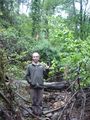
- ...so we followed the river.
- It meandered, as rivers like to do, so we took a few shortcuts through the brambles.
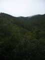
- Southern French undergrowth is pretty dense, as there is not much overgrowth to steal the sun.
- We approached the hash with every step, but we could not see the road Danatar mentioned, and it got dark quickly.
- We aborted the mission about 150m from the hash, when we would have had to leave the riverbed (again) to climb a steep cliff through more brambles.
Tracklog
Photos
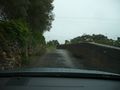
Narrow roads are narrow.
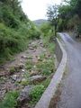
Approach road
A dry riverbed we would get to know better
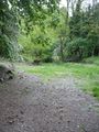
There were footpaths... still.
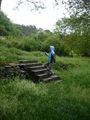
And stairs!
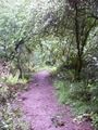
More paths.
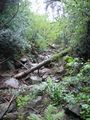
Then, the river. We followed this riverbed for about 1.5km.
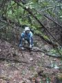
With a few exceptions, where the river was too cluttered.
250m to go, no "road" visible nowhere.
Back down, 150m to go, it got dark, and we despaired.
Did I mention it was drizzling raining all the time?

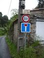
Danatar's message. Almost all you need to get me geohashing.


