Difference between revisions of "2010-05-21 52 13"
imported>Davidc (ribbon) |
imported>Davidc (+photos) |
||
| Line 27: | Line 27: | ||
<!-- if your GPS device keeps a log, you may post a link here --> | <!-- if your GPS device keeps a log, you may post a link here --> | ||
| − | == Photos == | + | == Photos == |
| − | + | ||
| − | + | I forgot to bring my camera, so excuse the poor quality and complete lack of horizontal alignment in these photos: | |
| − | + | ||
<gallery perrow="5"> | <gallery perrow="5"> | ||
| − | </gallery> | + | File:2010-05-21_52_13_IMG_0256.JPG|Horsies by Baruth station. |
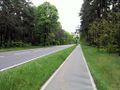
| + | File:2010-05-21_52_13_IMG_0260.JPG|Tree-lined avenue from station to the Baruth park. | ||
| + | File:2010-05-21_52_13_IMG_0262.JPG|A very cool but dilapidated building on stilts next to the rather marshy park. | ||
| + | File:2010-05-21_52_13_IMG_0264.JPG|Not long for this world. | ||
| + | File:2010-05-21_52_13_IMG_0265.JPG|Baruth park castle. | ||
| + | File:2010-05-21_52_13_IMG_0267.JPG|A travel bug and a gigantic oak holding geocache GC27F0Q. | ||
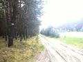
| + | File:2010-05-21_52_13_IMG_0270.JPG|Walking down the road toward Klasdorf. | ||
| + | File:2010-05-21_52_13_IMG_0272.JPG|Turn-off into what turned out to be a tract of land for a pipeline. | ||
| + | File:2010-05-21_52_13_IMG_0273.JPG|Pipeline pumping or monitoring station? | ||
| + | File:2010-05-21_52_13_IMG_0275.JPG|Mystery Box mark 2 - no box, just a lifeguard's chair! | ||
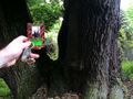
| + | File:2010-05-21_52_13_IMG_0276.JPG|Geodesic survey marker on a tree. | ||
| + | File:2010-05-21_52_13_IMG_0279.JPG|Geodesic survey stone. | ||
| + | File:2010-05-21_52_13_IMG_0280.JPG|Marker and stone together. | ||
| + | File:2010-05-21_52_13_IMG_0281.PNG|GPS coords of the marker. | ||
| + | File:2010-05-21_52_13_IMG_0283.JPG|Where in Berlin they number every single tree, out here in Brandenburg they only number each section of forest :-) | ||
| + | File:2010-05-21_52_13_IMG_0284.JPG|The pipeline tract opens up into a larger field, the hashpoint is beyond the far tree line, but... an electric fence! | ||
| + | File:2010-05-21_52_13_IMG_0286.JPG|Fortunately the fence ends abruptly and shows it was there for no reason at all. | ||
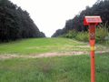
| + | File:2010-05-21_52_13_IMG_0287.JPG|Looking down the hashfield. The hashpoint is beyond the mystery box. | ||
| + | File:2010-05-21_52_13_IMG_0288.JPG|And turning the corner to see the hashpoint in the dead centre of this photo. | ||
| + | File:2010-05-21_52_13_IMG_0290.PNG|iPhone map proof. | ||
| + | File:2010-05-21_52_13_IMG_0292.PNG|iPhone GPS proof. | ||
| + | File:2010-05-21_52_13_IMG_0294.JPG|That's a cake. With two candles. Happy birthday, geohashing! | ||
| + | File:2010-05-21_52_13_IMG_0299.JPG|A tractor crosses the top of the hash field. | ||
| + | File:2010-05-21_52_13_IMG_0301.JPG|No poster, left a card. The tree sap glistens in the beating sun. | ||
| + | File:2010-05-21_52_13_IMG_0302.JPG|After a flat journey, heading downward back into civilisation. | ||
| + | File:2010-05-21_52_13_IMG_0303.JPG|Baruth has a few of these strange underground cellars dotted around in public places - not connected to any private property. | ||
| + | File:2010-05-21_52_13_IMG_0306.JPG|Roundabout joining the two major roads running through Baruth.</gallery> | ||
== Achievements == | == Achievements == | ||
{{#vardefine:ribbonwidth|800px}} | {{#vardefine:ribbonwidth|800px}} | ||
| − | {{Geohashing Day | latitude=52 | longitude=13 | year=2010 | coorddate=2010-05-21 | name=[[User:davidc|davidc]] | image= | + | {{Geohashing Day | latitude=52 | longitude=13 | year=2010 | coorddate=2010-05-21 | name=[[User:davidc|davidc]] | image=2010-05-21_52_13_IMG_0294.JPG}} |
[[Category:Expeditions]] | [[Category:Expeditions]] | ||
[[Category:Expeditions with photos]] | [[Category:Expeditions with photos]] | ||
[[Category:Coordinates reached]] | [[Category:Coordinates reached]] | ||
Revision as of 19:57, 21 May 2010
| Fri 21 May 2010 in 52,13: 52.0229115, 13.4999128 geohashing.info google osm bing/os kml crox |
Location
At the edge of a field near Baruth (Mark). It's Geohashing Day, let's make an attempt!
Participants
Plans
- It's a 1 hour train ride from Berlin to either Baruth(Mark) or Klasdorf Glashütte, either way there's then a 3-4km walk through the forest.
- Trains from Hbf (from Bernau and Gesundbrunnen, via Potsdamer Platz and Sudkreuz) run at 09:26, 11:26, 13:26, 14:26, 15:26, 16:26, ...
- Anyone else interested? --davidc 13:53, 20 May 2010 (UTC)
Expedition
- departing Hbf now. What a lovely day for geohashing day! --davidc 11:24, 21 May 2010 (UTC)
- davidc was there at 16:45. Story and photos when I've recovered.
Tracklog
Photos
I forgot to bring my camera, so excuse the poor quality and complete lack of horizontal alignment in these photos:
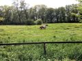
Horsies by Baruth station.
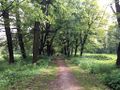
Tree-lined avenue from station to the Baruth park.
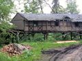
A very cool but dilapidated building on stilts next to the rather marshy park.
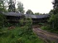
Not long for this world.
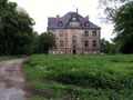
Baruth park castle.
A travel bug and a gigantic oak holding geocache GC27F0Q.
Walking down the road toward Klasdorf.
Turn-off into what turned out to be a tract of land for a pipeline.
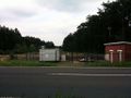
Pipeline pumping or monitoring station?
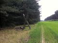
Mystery Box mark 2 - no box, just a lifeguard's chair!
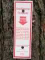
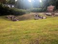
Geodesic survey marker on a tree.
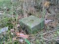
Geodesic survey stone.
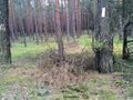
Marker and stone together.
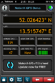
GPS coords of the marker.
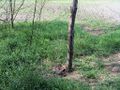
Where in Berlin they number every single tree, out here in Brandenburg they only number each section of forest :-)
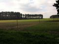
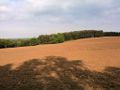
The pipeline tract opens up into a larger field, the hashpoint is beyond the far tree line, but... an electric fence!
Fortunately the fence ends abruptly and shows it was there for no reason at all.
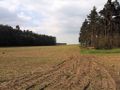
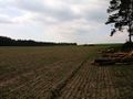
Looking down the hashfield. The hashpoint is beyond the mystery box.
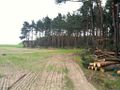
And turning the corner to see the hashpoint in the dead centre of this photo.
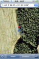
iPhone map proof.
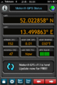
iPhone GPS proof.

That's a cake. With two candles. Happy birthday, geohashing!
A tractor crosses the top of the hash field.
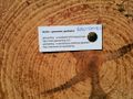
No poster, left a card. The tree sap glistens in the beating sun.
After a flat journey, heading downward back into civilisation.
Baruth has a few of these strange underground cellars dotted around in public places - not connected to any private property.
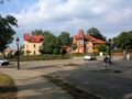
Roundabout joining the two major roads running through Baruth.


Achievements
davidc earned the 2010 Geohashing Day achievement
|