Difference between revisions of "2010-05-30 45 -122"
imported>Michael5000 m (→Achievements) |
imported>Jiml m (Adjust result codes - looks correctly catagorized) |
||
| Line 1: | Line 1: | ||
| − | |||
| − | |||
| − | |||
| − | |||
| − | |||
| − | |||
| − | |||
{{meetup graticule | {{meetup graticule | ||
| lat=45 | | lat=45 | ||
| Line 12: | Line 5: | ||
}} | }} | ||
| − | + | ||
__NOTOC__ | __NOTOC__ | ||
== Location == | == Location == | ||
| Line 43: | Line 36: | ||
Image:2010-05-30 45 -122 Bike.JPG | About 180 feet from... | Image:2010-05-30 45 -122 Bike.JPG | About 180 feet from... | ||
Image:2010-05-30 45 -122 Bear at Hashpoint.JPG | ...the Hashpoint! | Image:2010-05-30 45 -122 Bear at Hashpoint.JPG | ...the Hashpoint! | ||
| − | |||
| − | |||
</gallery> | </gallery> | ||
| − | |||
| − | |||
[[Category:Expeditions]] | [[Category:Expeditions]] | ||
[[Category:Expeditions with photos]] | [[Category:Expeditions with photos]] | ||
[[Category:Coordinates reached]] | [[Category:Coordinates reached]] | ||
Revision as of 03:11, 11 June 2010
| Sun 30 May 2010 in 45,-122: 45.7345936, -122.3636490 geohashing.info google osm bing/os kml crox |
Location
Forested foothills northeast of Vancouver.
Participants
Plans
This is the kind of hashpoint I have been hoping for since taking up geohashing. The aerial image suggested but did not guarantee accessibility, and the location would require exploration, a little foresight, and a modicum of physical effort. I made a careful sketch of the hashpoint area and noted the road route, packed a few supplies, and left on the expedition at noon on the dot.
Expedition
Increasingly narrow rural roads took me into the area of the hashpoint, but as I had anticipated the last road I would need to go on was gated. No problem: timber companies don't restrict access, just motorized access, so I began the second stage of the triathlon, hoisting my bike over the gate.
In a way, the bicycle was overkill, as I only had to pedal .38 miles to the point where the road was closest to the point. It was VERY close to the point, actually: the third leg of the triathlon, on foot, was less than 200 feet through three or four year old clearcut scrub. I used the GPS gadget, which finally came in useful -- it zeroed me right in on the exact spot in the clearing where the hashpoint sat.
This was my favorite hashpoint to date. One that required a slightly longer ride, a slightly longer hike, a slightly greater complexity of strategizing the final approach -- that would all add to the fun. But this one was pretty darn fun -- especially since I got back to the truck before it started to rain.
I left a flag in the event that any other wanderers happen across the site.
Photos

Me at the Hashpoint
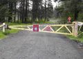
Google Maps doesn't mention this sort of thing...
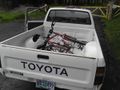
...but I'm from around here.
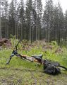
About 180 feet from...
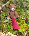
...the Hashpoint!


