Difference between revisions of "2010-07-05 45 -122"
imported>Jiml (Draft 2 of the report) |
imported>FippeBot m (Location) |
||
| (One intermediate revision by one other user not shown) | |||
| Line 12: | Line 12: | ||
== Location == | == Location == | ||
| − | + | A home near Garden Home, Oregon | |
== Participants == | == Participants == | ||
| Line 29: | Line 29: | ||
I never found the correct turn off the Capital Highway, but I followed my GPS, and finally got there. | I never found the correct turn off the Capital Highway, but I followed my GPS, and finally got there. | ||
| − | My GPS was suddenly having trouble | + | My GPS was suddenly having trouble staying locked on the signal. I was 60 feet away and it would point in |
| − | one direction, and then completely | + | one direction, and then completely spin around. It was in a urban area, so there wasn't a lot |
of overhead trees to explain this. I finally was going to ask permission to enter a backyard, but | of overhead trees to explain this. I finally was going to ask permission to enter a backyard, but | ||
| − | it hit 21 feet upon entering the driveway, so I | + | it hit 21 feet upon entering the driveway, so I decided to take a picture and declare it a success. |
== Photos == | == Photos == | ||
| − | + | <gallery perrow="5"> | |
| + | Image:2010-07-05_45_-122-near2.jpg | There were walking paths in the area | ||
| + | Image:2010-07-05_45_-122-near1.jpg | Area near the hashpoint | ||
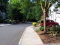
| − | + | Image:2010-07-05_45_-122-near3.jpg | Another view of the neighborhood | |
| − | Image: | + | Image:2010-07-05_45_-122-near4.jpg | Another Honda Element near a hashpoint! |
| − | -- | + | Image:2010-07-05_45_-122-gps.jpg | Yes - the GPS made it |
| − | + | Image:2010-07-05_45_-122-grin.jpg | As did I | |
</gallery> | </gallery> | ||
== Achievements == | == Achievements == | ||
{{#vardefine:ribbonwidth|800px}} | {{#vardefine:ribbonwidth|800px}} | ||
| − | |||
| − | + | {{land_geohash | |
| + | | latitude = 45 | ||
| + | | longitude = -122 | ||
| + | | date = 2010-07-05 | ||
| + | | name = [[User:Jiml|Jim]] | ||
| + | }} | ||
| + | |||
[[Category:Expeditions]] | [[Category:Expeditions]] | ||
| − | |||
[[Category:Expeditions with photos]] | [[Category:Expeditions with photos]] | ||
| − | |||
| − | |||
[[Category:Coordinates reached]] | [[Category:Coordinates reached]] | ||
| + | {{location|US|OR|MU}} | ||
Latest revision as of 02:39, 9 August 2019
| Mon 5 Jul 2010 in 45,-122: 45.4697853, -122.7430819 geohashing.info google osm bing/os kml crox |
Location
A home near Garden Home, Oregon
Participants
Plans
I thought there were no feasible (for me) hashpoints this weekend, but apparently, I forgot to look at Monday. I'm already in Portland to donate blood, so I'm going to go swing by and try for this one.
Expedition
I went by, but I didn't quite make it by four, despite what Google Maps told me.
I never found the correct turn off the Capital Highway, but I followed my GPS, and finally got there.
My GPS was suddenly having trouble staying locked on the signal. I was 60 feet away and it would point in one direction, and then completely spin around. It was in a urban area, so there wasn't a lot of overhead trees to explain this. I finally was going to ask permission to enter a backyard, but it hit 21 feet upon entering the driveway, so I decided to take a picture and declare it a success.
Photos
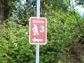
There were walking paths in the area
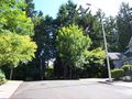
Area near the hashpoint
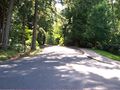
Another view of the neighborhood
Another Honda Element near a hashpoint!
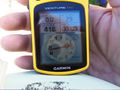
Yes - the GPS made it

As did I


Achievements
Jim earned the Land geohash achievement
|