Difference between revisions of "2010-07-10 45 -122"
imported>Jiml m (Report tweaking) |
imported>Jiml m (Tweak report) |
||
| Line 33: | Line 33: | ||
It was nice and clear, so I got to see Mt. Hood on my way out. | It was nice and clear, so I got to see Mt. Hood on my way out. | ||
| − | So, | + | So, I first headed to the Farmer's market to get stuff for the coming week. |
After finding berries and beans, he was talking to the gelato folks and they | After finding berries and beans, he was talking to the gelato folks and they | ||
mentioned that they were going to have sailing lessons in a month or so. I asked | mentioned that they were going to have sailing lessons in a month or so. I asked | ||
| Line 49: | Line 49: | ||
was astonished at how much the hashpoint was north rather than | was astonished at how much the hashpoint was north rather than | ||
east. I went into Portland and headed up towards the Oregon-Washington | east. I went into Portland and headed up towards the Oregon-Washington | ||
| − | border on Hwy I-5. I | + | border on Hwy I-5. I exited right before crossing. The streets |
weren't quite as clear as I had hoped, but eventually I managed to | weren't quite as clear as I had hoped, but eventually I managed to | ||
find the road that would get me close to the shore. However, halfway | find the road that would get me close to the shore. However, halfway | ||
| Line 55: | Line 55: | ||
moving train. | moving train. | ||
| − | Prior to getting to that point, I had ended up | + | Prior to getting to that point, I had ended up near a private marina that I couldn't |
| − | access | + | access either, so clearly the shoreline on Hayden Island was inaccessible. I took |
a few pictures and went back, trying to get close to the shore from the Portland side, but | a few pictures and went back, trying to get close to the shore from the Portland side, but | ||
that didn't prove successful either. | that didn't prove successful either. | ||
| Line 81: | Line 81: | ||
<!-- Add any achievement ribbons you earned below, or remove this section --> | <!-- Add any achievement ribbons you earned below, or remove this section --> | ||
| + | * No Trespassing | ||
[[Category:Expeditions]] | [[Category:Expeditions]] | ||
Revision as of 20:53, 8 August 2010

| Sat 10 Jul 2010 in 45,-122: 45.6311590, -122.7338689 geohashing.info google osm bing/os kml crox |
Location
In a side channel of the Columbia River near Hayden Island.
Yes: IN the Columbia River.
Participants
Plans
Jim is headed to the Farmer's Market, and then thinks he'll try and see what the area looks like. He doubts he'll have access from the Marine Drive side, due to the rail yard, but is going to see if it looks better from the Hayden Island side. If nothing else, he gets to look at this off-ramp of Hwy I-5!
Sounds like an adventure.
Expedition
I finally finished up the stuff I was working on at home and headed out. It was a little warm, but it was supposed to be much cooler than yesterday, so that was nice. It was nice and clear, so I got to see Mt. Hood on my way out.
So, I first headed to the Farmer's market to get stuff for the coming week. After finding berries and beans, he was talking to the gelato folks and they mentioned that they were going to have sailing lessons in a month or so. I asked about what sort of craft, and they said it was a smaller sailboat on the Columbia. My ears perked up, and then they said that the dock was located on Hayden Island!
Clearly the universe wanted me to be try for the hashpoint and was going to provide lots of reminders! I let them know where I was planning on heading and they were amused. They wanted to know how I was going to get out into the channel, and I said I didn't think I'd get any closer than the shore, but it would be an adventure.
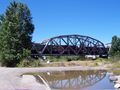
After finishing up visiting with folks and getting things, I headed east. I happened to check the GPS before I got too far out and was astonished at how much the hashpoint was north rather than east. I went into Portland and headed up towards the Oregon-Washington border on Hwy I-5. I exited right before crossing. The streets weren't quite as clear as I had hoped, but eventually I managed to find the road that would get me close to the shore. However, halfway down the road, a fence showed up, and a couple of train tracks, one with a moving train.
Prior to getting to that point, I had ended up near a private marina that I couldn't access either, so clearly the shoreline on Hayden Island was inaccessible. I took a few pictures and went back, trying to get close to the shore from the Portland side, but that didn't prove successful either.
So, I went hope, doing a little more grocery shopping on the way.
Photos
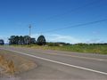
Part of the route to the hashpoint
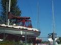
A boat near the hashpoint
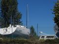
Another boat near the hashpoint
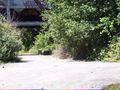
The pathway towards the hashpoint
Another water hazard
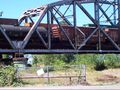
Train crossing the path towards the hashpoint


Achievements
- No Trespassing