Difference between revisions of "2010-07-17 45 -122"
From Geohashing
imported>Jiml (Partial report) |
imported>Michael5000 (Photo) |
||
| Line 56: | Line 56: | ||
<!-- if your GPS device keeps a log, you may post a link here --> | <!-- if your GPS device keeps a log, you may post a link here --> | ||
| − | + | ||
== Photos == | == Photos == | ||
| − | |||
| − | |||
| − | |||
<gallery perrow="5"> | <gallery perrow="5"> | ||
| + | Image:2010-07-17 45 -122 Geohash.jpg | Michael5000 & Mrs.5000 en route | ||
| + | |||
| + | |||
</gallery> | </gallery> | ||
| − | + | ||
== Achievements == | == Achievements == | ||
{{#vardefine:ribbonwidth|800px}} | {{#vardefine:ribbonwidth|800px}} | ||
Revision as of 02:59, 18 July 2010
| Sat 17 Jul 2010 in 45,-122: 45.5687441, -122.5352076 geohashing.info google osm bing/os kml crox |
Location
Near I-205 and Marine Drive Blvd in Portland
Participants
- Michael5000 and Mrs.5000
Plans
This location looks like it is on the street side of a fence adjacent to Marine Blvd, so it should be pretty easy to access.
Expedition
The 5000's
- Michael & Mrs.5000 rode a 21.1 mile bicycle loop that included the lovely airport/Columbia river bike trail and the less lovely northern few miles of the I-205 bike trail on their way to their first ever non-motorized geohash expedition. At 21.1 miles, it was the longest ride of the year so far for both 5000s.
Michael5000 & Mrs.5000 earned the Bicycle geohash achievement
|
Note: The site is a little overgrown with tall grasses and requires some very minor bushwhacking.
Jim
Jim made it as well, but it was somewhat of a challenge due to bridge construction. He gave up on driving very close to the hashpoint and walked through the traffic.
He also got a Police Geohash out of it, indirectly, and saw what must have been an ice cream truck escaped from over an ocean.
More details after dinner.
Photos
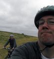
Michael5000 & Mrs.5000 en route
