Difference between revisions of "2010-07-17 45 -122"
imported>Jiml (Add Photos) |
imported>FippeBot m (Location) |
||
| (6 intermediate revisions by 2 users not shown) | |||
| Line 10: | Line 10: | ||
__NOTOC__ | __NOTOC__ | ||
== Location == | == Location == | ||
| − | Marine Drive | + | Marine Drive near the I-205 bridge in Portland |
== Participants == | == Participants == | ||
| Line 19: | Line 19: | ||
== Plans == | == Plans == | ||
| − | This location looks like it is on the street side of a fence adjacent to Marine | + | This location looks like it is on the street side of a fence adjacent to Marine Drive, so it should |
be pretty easy to access. | be pretty easy to access. | ||
| Line 25: | Line 25: | ||
== Expedition == | == Expedition == | ||
| − | === | + | === Expedition One === |
*Michael & Mrs.5000 rode a 21.1 mile bicycle loop that included the lovely airport/Columbia river bike trail and the less lovely northern few miles of the I-205 bike trail on their way to their first ever non-motorized geohash expedition. At 21.1 miles, it was the longest ride of the year so far for both 5000s. | *Michael & Mrs.5000 rode a 21.1 mile bicycle loop that included the lovely airport/Columbia river bike trail and the less lovely northern few miles of the I-205 bike trail on their way to their first ever non-motorized geohash expedition. At 21.1 miles, it was the longest ride of the year so far for both 5000s. | ||
| − | |||
| − | |||
| − | |||
| − | |||
| − | |||
| − | |||
| − | |||
Note: The site is a little overgrown with tall grasses and requires some very minor bushwhacking. | Note: The site is a little overgrown with tall grasses and requires some very minor bushwhacking. | ||
| − | === | + | === Expedition Two === |
| − | |||
| − | |||
| − | + | I started out for the hashpoint after leaving the Farmer's Market where I got lots of veggies | |
| − | + | and some promises for items next week that wouldn't have been happy with | |
| − | |||
| − | |||
| − | |||
| − | |||
| − | |||
| − | and some promises | ||
traveling to the Columbia River and back before they got into the fridge/freezer. | traveling to the Columbia River and back before they got into the fridge/freezer. | ||
On the way, I discovered that my "smart" phone was being pretty dumb, and didn't seem to | On the way, I discovered that my "smart" phone was being pretty dumb, and didn't seem to | ||
| − | be able to | + | be able to talk to the Internet. As a result, I needed to make |
| − | a stop on the way to the hashpoint to set up an appointment in person. | + | a stop on the way to the hashpoint to set up an appointment in person, since I didn't |
| + | know the whole phone number. | ||
| − | In Portland, there are two main bridges over the Columbia River (and to Washington State): | + | In Portland, there are two main bridges over the Columbia River (and thus to Washington State): |
| − | Each of them has an Interstate Highway running over them, I-5 and I-205. I | + | Each of them has an Interstate Highway running over them, I-5 and I-205. (I-205 is "Glenn Jackson", I |
| − | attempted to take I-5 up towards the Columbia, but when the traffic ground to a complete halt, | + | was surprised to learn.) |
| − | I bailed out and | + | I attempted to take I-5 up towards the Columbia, but when the traffic ground to a complete halt, |
| − | and the hashpoint | + | I bailed out and took side streets. I eventually got close to I-205 |
| − | was there | + | and the hashpoint. I went around a loop 3 times looking for a road that Google said |
| − | loop because the traffic was very heavy for some reason. | + | was there, but didn't seem to be. I had to keep dodging around at the end of the |
| + | loop because the traffic was very heavy for some reason I didn't understand at that | ||
| + | point. | ||
I finally gave up and decided to dive into the traffic to get close to the Hashpoint, | I finally gave up and decided to dive into the traffic to get close to the Hashpoint, | ||
| − | especially since I didn't see a way through. After sitting in traffic for 15 minutes | + | especially since I didn't see a way through from |
| − | and barely moving, I realized the hashpoint was a half mile away, and I could park and | + | the side I was on. After sitting in traffic for 15 minutes |
| + | and barely moving, I realized the since | ||
| + | the hashpoint was a half mile away, and I could just park and | ||
walk faster. So, I parked near the support center for the local school district and | walk faster. So, I parked near the support center for the local school district and | ||
hoofed it out into the traffic. | hoofed it out into the traffic. | ||
As I walked around I found two things: First, there was a big flashing sign that | As I walked around I found two things: First, there was a big flashing sign that | ||
| − | said there was Bridge work on the I-205 bridge, which is why traffic was completely | + | said there was "Bridge work on the I-205 bridge", which is why traffic was completely |
unmoving over all of the North edge of Portland. The second item was that the | unmoving over all of the North edge of Portland. The second item was that the | ||
second road I was heading for didn't really exist either. It was a bike/walking trail, | second road I was heading for didn't really exist either. It was a bike/walking trail, | ||
| − | so it was a good thing I was walking. I walked up to Marine | + | so it was a good thing I was walking. I walked up to Marine Drive, and walked along |
it towards the hashpoint. As soon as I came up onto the road, I saw a very pretty view | it towards the hashpoint. As soon as I came up onto the road, I saw a very pretty view | ||
| − | of Mount Hood and the Columbia. Since I didn't have to watch the road, I was able to | + | of Mount Hood and the Columbia River. Since I didn't have to watch the road, I was able to |
| − | enjoy it and take some pictures. When I got to where the hashpoint was, I had to | + | enjoy it and take some pictures. When I got to where the hashpoint was, I |
| − | cross the road, which took | + | actually had to |
| + | cross the road, which took bit of time, since traffic had to clear. | ||
| − | + | Finally on the other side, I went down down the embankment (which the 5000's had forgotten) | |
| − | + | and wandered amid the "tall grass" doing the GPS dance. After I was done dancing, I noticed | |
a gate in the fence that was completely unlocked. I looked into the fenced area and | a gate in the fence that was completely unlocked. I looked into the fenced area and | ||
realized that there were a lot of different companies sharing that warehouse space, so | realized that there were a lot of different companies sharing that warehouse space, so | ||
| − | + | they probably regarded the area as "public" space. As I walked out through the parking | |
| − | I found the whole area open, so they weren't | + | lot, |
| − | through. If I had | + | I found the whole area open, so they weren't fussy about people passing |
| − | the hashpoint without having to walk all the way around | + | through. If I had searched more broadly in the first case, I might have found that gate to |
| − | + | the hashpoint without having to walk all the way around, but there weren't really any | |
| − | + | good places to stop on Marine Drive, so it is | |
probably just as well I didn't | probably just as well I didn't | ||
| − | make it to there. | + | make it to there. And I would have missed out those really pretty sights of |
| + | the Columbia and Mount Hood. | ||
I headed back towards home, heading as directly away from the traffic jam | I headed back towards home, heading as directly away from the traffic jam | ||
that was the I-205 bridge as possible. This construction doesn't bode | that was the I-205 bridge as possible. This construction doesn't bode | ||
| − | well for my | + | well for my expedition tomorrow, though. (Later investigation |
| + | reveals that 2 lanes of I-205 are closed for construction, and that ODOT | ||
| + | expects the I-5 bridge will be raised often for river traffic.) | ||
On my way home, I stopped at a market to pick up several different | On my way home, I stopped at a market to pick up several different | ||
| Line 110: | Line 104: | ||
By now we had a couple of other cars stopped by now, and when I looked | By now we had a couple of other cars stopped by now, and when I looked | ||
| − | around, I realized that a police car had stopped and the | + | around, I realized that a police car had stopped and the officer had |
just walked up behind us. He asked the teen if it was okay if a | just walked up behind us. He asked the teen if it was okay if a | ||
paramedic checked him out, but I think the kid pretty much wanted | paramedic checked him out, but I think the kid pretty much wanted | ||
| − | to get out of there. | + | to get out of there. Shortly after, ''another'' police car |
| − | I knew, most of us cleared out | + | showed up - apparently it had been thought to be a bigger deal |
| + | than it was. But, since I'd already let the officer know what | ||
| + | I knew, most of us cleared out. | ||
I headed home, but before | I headed home, but before | ||
| Line 120: | Line 116: | ||
right hand drive! I assume it must have escaped over an ocean to here, | right hand drive! I assume it must have escaped over an ocean to here, | ||
from the UK, or Down Under, or maybe Japan, but I doubt the latter. | from the UK, or Down Under, or maybe Japan, but I doubt the latter. | ||
| + | I was driving, so no picture. | ||
| − | |||
| − | |||
| − | |||
| − | |||
== Photos == | == Photos == | ||
| − | |||
| − | |||
<gallery perrow="5"> | <gallery perrow="5"> | ||
Image:2010-07-17 45 -122 Geohash.jpg | Michael5000 & Mrs.5000 en route | Image:2010-07-17 45 -122 Geohash.jpg | Michael5000 & Mrs.5000 en route | ||
| − | Image:2010-07-17_45_-122-area1.jpg | The | + | Image:2010-07-17_45_-122-area1.jpg | The warehouse adjacent to the hashpoint |
Image:2010-07-17_45_-122-area2.jpg | The area around the hashpoint | Image:2010-07-17_45_-122-area2.jpg | The area around the hashpoint | ||
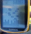
Image:2010-07-17_45_-122-gps1.jpg | Proof of distance | Image:2010-07-17_45_-122-gps1.jpg | Proof of distance | ||
| Line 149: | Line 140: | ||
== Achievements == | == Achievements == | ||
{{#vardefine:ribbonwidth|800px}} | {{#vardefine:ribbonwidth|800px}} | ||
| − | |||
| − | - | + | {{Bicycle geohash |
| − | + | | latitude = 45 | |
| + | | longitude = -122 | ||
| + | | date = 2010-07-17 | ||
| + | | name = Michael5000 & Mrs.5000 | ||
| + | | distance = 21.1 miles | ||
| + | }} | ||
| + | |||
| + | {{land geohash | ||
| + | | latitude = 45 | ||
| + | | longitude = -122 | ||
| + | | date = 2010-07-17 | ||
| + | | name = Michael5000 & Mrs.5000 & [[User:Jiml|Jim]] | ||
| + | }} | ||
| + | |||
| + | |||
| + | {{police geohash | ||
| + | | latitude = 45 | ||
| + | | longitude = -122 | ||
| + | | date = 2010-07-17 | ||
| + | | name = [[User:Jiml|Jim]] | ||
| + | | encounter = meeting multiple officers | ||
| + | }} | ||
| Line 159: | Line 170: | ||
[[Category:Coordinates reached]] | [[Category:Coordinates reached]] | ||
[[Category:Expeditions with photos]] | [[Category:Expeditions with photos]] | ||
| + | {{location|US|OR|MU}} | ||
Latest revision as of 02:50, 9 August 2019

| Sat 17 Jul 2010 in 45,-122: 45.5687441, -122.5352076 geohashing.info google osm bing/os kml crox |
Location
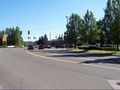
Marine Drive near the I-205 bridge in Portland
Participants
- Michael5000 and Mrs.5000
Plans
This location looks like it is on the street side of a fence adjacent to Marine Drive, so it should be pretty easy to access.
Expedition
Expedition One
- Michael & Mrs.5000 rode a 21.1 mile bicycle loop that included the lovely airport/Columbia river bike trail and the less lovely northern few miles of the I-205 bike trail on their way to their first ever non-motorized geohash expedition. At 21.1 miles, it was the longest ride of the year so far for both 5000s.
Note: The site is a little overgrown with tall grasses and requires some very minor bushwhacking.
Expedition Two
I started out for the hashpoint after leaving the Farmer's Market where I got lots of veggies and some promises for items next week that wouldn't have been happy with traveling to the Columbia River and back before they got into the fridge/freezer.
On the way, I discovered that my "smart" phone was being pretty dumb, and didn't seem to be able to talk to the Internet. As a result, I needed to make a stop on the way to the hashpoint to set up an appointment in person, since I didn't know the whole phone number.
In Portland, there are two main bridges over the Columbia River (and thus to Washington State): Each of them has an Interstate Highway running over them, I-5 and I-205. (I-205 is "Glenn Jackson", I was surprised to learn.) I attempted to take I-5 up towards the Columbia, but when the traffic ground to a complete halt, I bailed out and took side streets. I eventually got close to I-205 and the hashpoint. I went around a loop 3 times looking for a road that Google said was there, but didn't seem to be. I had to keep dodging around at the end of the loop because the traffic was very heavy for some reason I didn't understand at that point.
I finally gave up and decided to dive into the traffic to get close to the Hashpoint, especially since I didn't see a way through from the side I was on. After sitting in traffic for 15 minutes and barely moving, I realized the since the hashpoint was a half mile away, and I could just park and walk faster. So, I parked near the support center for the local school district and hoofed it out into the traffic.
As I walked around I found two things: First, there was a big flashing sign that said there was "Bridge work on the I-205 bridge", which is why traffic was completely unmoving over all of the North edge of Portland. The second item was that the second road I was heading for didn't really exist either. It was a bike/walking trail, so it was a good thing I was walking. I walked up to Marine Drive, and walked along it towards the hashpoint. As soon as I came up onto the road, I saw a very pretty view of Mount Hood and the Columbia River. Since I didn't have to watch the road, I was able to enjoy it and take some pictures. When I got to where the hashpoint was, I actually had to cross the road, which took bit of time, since traffic had to clear.
Finally on the other side, I went down down the embankment (which the 5000's had forgotten) and wandered amid the "tall grass" doing the GPS dance. After I was done dancing, I noticed a gate in the fence that was completely unlocked. I looked into the fenced area and realized that there were a lot of different companies sharing that warehouse space, so they probably regarded the area as "public" space. As I walked out through the parking lot, I found the whole area open, so they weren't fussy about people passing through. If I had searched more broadly in the first case, I might have found that gate to the hashpoint without having to walk all the way around, but there weren't really any good places to stop on Marine Drive, so it is probably just as well I didn't make it to there. And I would have missed out those really pretty sights of the Columbia and Mount Hood.
I headed back towards home, heading as directly away from the traffic jam that was the I-205 bridge as possible. This construction doesn't bode well for my expedition tomorrow, though. (Later investigation reveals that 2 lanes of I-205 are closed for construction, and that ODOT expects the I-5 bridge will be raised often for river traffic.)
On my way home, I stopped at a market to pick up several different frozen fish, including whole sardines that we're going to have to figure out how to cook. I usually take a back road out of this market and I went out that way since it has less traffic. After a block or so, I noticed some kids riding bikes a couple of blocks ahead. Suddenly, one of the kids hit a curb wrong and went flying onto the sidewalk. By the time I drove the block up to him, he still was flat out, not moving, so I was pretty worried as I stopped my car and got out to see how he was. He was a little scraped up, but didn't seem to have any internal injuries. Well, other than a major bruise on the ego.
By now we had a couple of other cars stopped by now, and when I looked around, I realized that a police car had stopped and the officer had just walked up behind us. He asked the teen if it was okay if a paramedic checked him out, but I think the kid pretty much wanted to get out of there. Shortly after, another police car showed up - apparently it had been thought to be a bigger deal than it was. But, since I'd already let the officer know what I knew, most of us cleared out.
I headed home, but before I reached my next stop, I encountered an Ice Cream truck, but with right hand drive! I assume it must have escaped over an ocean to here, from the UK, or Down Under, or maybe Japan, but I doubt the latter. I was driving, so no picture.
Photos
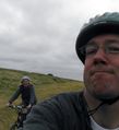
Michael5000 & Mrs.5000 en route
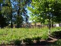
The warehouse adjacent to the hashpoint
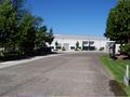
The area around the hashpoint
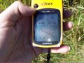
Proof of distance
Proof of location

Look - a hashpoint!
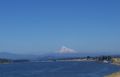
Our photogenic mountain
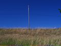
The slope up to Marine Drive
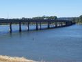
The traffic stuck on I-205 Bridge
Traffic stuck on a side street


Achievements
Michael5000 & Mrs.5000 earned the Bicycle geohash achievement
|
Michael5000 & Mrs.5000 & Jim earned the Land geohash achievement
|
Jim earned the Police Geohash Achievement
|