Difference between revisions of "2010-07-25 45 -122"
From Geohashing
imported>Michael5000 m (→Photos) |
imported>Michael5000 m |
||
| Line 1: | Line 1: | ||
| − | |||
| − | [[ | + | [[File:2010-07-25 45 -122 Landscape.JPG|The area around the hashpoint.|thumb|left]] |
| − | |||
| − | |||
| − | |||
| − | |||
| − | |||
{{meetup graticule | {{meetup graticule | ||
| lat=45 | | lat=45 | ||
| Line 66: | Line 60: | ||
[[Category:Expedition planning]] | [[Category:Expedition planning]] | ||
| − | |||
[[Category:Expeditions]] | [[Category:Expeditions]] | ||
| − | |||
[[Category:Expeditions with photos]] | [[Category:Expeditions with photos]] | ||
| − | |||
| − | |||
| − | |||
| − | |||
[[Category:Coordinates reached]] | [[Category:Coordinates reached]] | ||
| − | |||
| − | |||
| − | |||
| − | |||
| − | |||
| − | |||
| − | |||
| − | |||
| − | |||
| − | |||
Revision as of 17:46, 25 July 2010

| Sun 25 Jul 2010 in 45,-122: 45.5182129, -122.6414956 geohashing.info google osm bing/os kml crox |
Location
Lone Fir Cemetery in Portland
Participants
- Jim is strongly thinking about it
Plans
Jim's thinking about it, and trying to figure out how to make it interesting....
APR can't make it.
Expedition
Michael5000 woke up and checked the hashpoint. "Holy cat!" he exclaimed to Mrs.5000. "We're going geohashing!" And they walked down the street to the hashpoint in nearby Lone Fir Cemetery.
Michael5000 and Mrs.5000 earned the Walk geohash Achievement
|
Photos
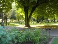
The area around the hashpoint.

Michael5000
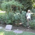
Mrs.5000, looking ghostly
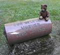
A hashcot, oblivious of cemetery etiquette. He meant no disrespect.
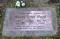
The nearest posthumous geohasher.


