Difference between revisions of "2010-08-17 45 -122"
imported>Jiml (Fill in first pass) |
imported>FippeBot m (Location) |
||
| (One intermediate revision by one other user not shown) | |||
| Line 64: | Line 64: | ||
== Photos == | == Photos == | ||
| − | |||
| − | |||
| − | |||
| − | |||
<gallery perrow="5"> | <gallery perrow="5"> | ||
| + | Image:2010-08-17 45 -122-route.jpg | View along the route | ||
| + | Image:2010-08-17 45 -122-hashview.jpg | View of a very dark hashpoint | ||
</gallery> | </gallery> | ||
| + | |||
| + | |||
== Achievements == | == Achievements == | ||
| Line 86: | Line 86: | ||
[[Category:Not reached - Mother Nature]] | [[Category:Not reached - Mother Nature]] | ||
| + | {{location|US|OR|MU}} | ||
Latest revision as of 03:21, 9 August 2019
| Tue 17 Aug 2010 in 45,-122: 45.5622128, -122.4502247 geohashing.info google osm bing/os kml crox |
Location
On McGuire Island SE of Goverment Island in the Columbia River
Participants
Plans
I had long given up on even trying for this hash when in the middle of the day I found that I had to go into Portland for an errand. So, I printed out a Google Maps page, and headed out.
Expedition
How did it turn out?
Let's see. A hashpoint on an island in the middle of the Columbia by someone without a boat. How do you think this was going to turn out?
So, the first thing I did was to call the Oregon Parks department to find out info. The islands didn't appear to be part of the nearby Government Island Recreation area, but I figured the department might know about them.
They thought it were called McGuire Island and accessing them was fine. (Assuming you have a way to get there.... :-) )
So, with my Google maps sheet in hand, I headed to Portland, taking a break to program the GPS. But first I needed to head to the "Hillsboro Tuesday Marketplace" for blueberries. As I walked to the market, I started to program the GPS. I got to the last digit of the coordinates when the screen faded.
Oops - dead batteries. I guess I'll program it when I get back to the car.
A half hour later, I dig the spare pair of batteries out of the camera box. The GPS turns on, but shows very low batteries. Great. That's two sets of dead batteries. Finally, I pull the batteries from the camera which seem to be fully charged and bring the GPS to life.
I switch batteries to the Camera for a picture or so when I'm on the way, then return them to the GPS.
I head into Portland, handle my errand, and continue on (in the gloom) to the Columbia. It's dark by the time I get there. I drive by the hashpoint at a distance of about 0.33 miles or so, take some pictures that mostly prove hopeless, and head homeward.
Photos
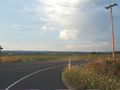
View along the route

View of a very dark hashpoint


Achievements
- MNB? Not really
- Kingdom for a boat? Wasn't unexpected...