Difference between revisions of "2010-08-21 44 -87"
imported>Bassoon (Created page with '{{subst:Expedition |lat = 44 |lon = 87 |date = 2010-08-21 }}') |
imported>Bassoon |
||
| Line 1: | Line 1: | ||
| − | |||
| − | |||
| − | |||
| − | |||
| − | |||
| − | |||
| − | |||
| − | |||
| − | |||
| − | |||
{{meetup graticule | {{meetup graticule | ||
| lat=44 | | lat=44 | ||
| Line 15: | Line 5: | ||
}} | }} | ||
| − | |||
| − | |||
== Location == | == Location == | ||
| − | + | In a church near St. Nazianz, Wisconsin. | |
== Participants == | == Participants == | ||
| − | + | * [[User:Bassoon|Bassoon]] | |
| + | * [[User:Dedehawk|Dedehawk]] | ||
| + | * [[User:PainJain21|PainJain]] | ||
== Plans == | == Plans == | ||
| − | + | Seeing as we had no idea what that odd building was, show up, hope the grounds were public, and take some photos. | |
== Expedition == | == Expedition == | ||
| − | + | Oh, lord. Literally. | |
| − | + | We started out from PainJain's house at around 3 PM. We followed I-43 for about an hour and a half, stopping in Saukville for some Taco Bell action. The lady wasn't very polite, but we didn't have to deal with her too long before we were back on the way. At some point, Bassoon, who is a cemetery aficionado, spotted a tiny cemetery set off of I-43 a bit. He made a mental note to stop on the way back. | |
| − | + | ||
| + | We eventually took exit 144 and made our way to St. Nazianz (or as we'd fondly dubbed it, "St. Nasty Ass"). Eventually, we rolled up to the hash and found it looking suspiciously like a church. | ||
| + | |||
| + | Oh no. Oh god no. | ||
| + | |||
| + | Everyone started freaking out. We had no idea what the building actually was. From the overhead view Google Maps had, it looked like a stadium or some sort of track. But it wasn't. It was a church. A freaking church, man! Not only that. A church with a service happening inside! | ||
| + | |||
| + | Seeing as the hash was inside the building, we tried to figure out where exactly the hash fell. With a little investigation, we realized the hash fell inside the room where the service was occurring. No way. NO WAY. | ||
| + | |||
| + | We decided to come back a little later after getting food in Manitowoc. If we could get the priest's permission to enter the hall and take a photo, we'd qualify for ambassador, too! | ||
| + | |||
| + | So we left and got Culver's in Manitowoc. When we came back, the service was over and a few people remained standing by the door. After waiting a few minutes to let the random passersby disperse, we tried the doors. Locked. Darn. After the passersby drove off, we walked around the back of the church, by the windows to the hall. It was the closest we could get, but it would have to do. Besides, a sign for the church cemetery declared it to be open until dusk. So we were in the green for our hashing photos on church property! | ||
| + | |||
| + | We took the requisite photos and then made our way back home. We checked for possible squishy vendors within 5 kilometers of the church, but alas, rural Wisconsin did not deliver. On the way back, we stopped at the little cemetery at the side of the road. Quite an interesting place. | ||
| + | |||
| + | Overall, it was a really good trip to take down another virgin graticule, which was awkwardly situated on a holy hash simultaneously. Taking a cherry at a church? Dirty. | ||
== Photos == | == Photos == | ||
| Line 37: | Line 42: | ||
--> | --> | ||
<gallery perrow="5"> | <gallery perrow="5"> | ||
| + | Image:2010-08-21 44 -87 thecar.png | The Car in the parking lot during the service. | ||
| + | Image:2010-08-21_44_-87_thesign.png | The Sign, saying when the service began. | ||
| + | Image:2010-08-21 44 -87 thetime.png | The Time when we arrived. The service is in session! | ||
| + | Image:2010-08-21_44_-87_victoire.png | Victoire! We have arrived! | ||
| + | Image:2010-08-21_44_-87_groupshot.png| Our groupshot, with an inexplicably warm, heavenly glow. | ||
| + | Image:2010-08-21_44_-87_thechurch.png | The Church, with a halo of light, possibly with a heavenly choir and flying cherubim. | ||
</gallery> | </gallery> | ||
== Achievements == | == Achievements == | ||
{{#vardefine:ribbonwidth|800px}} | {{#vardefine:ribbonwidth|800px}} | ||
| − | + | {{land geohash | |
| − | + | | latitude = 44 | |
| − | + | | longitude = -87 | |
| − | + | | date = 2010-08-21 | |
| − | + | | name = Bassoon, Dedehawk, and PainJain | |
| − | + | | image = 2010-08-21_44_-87_victoire.png | |
| − | + | }} | |
| − | + | {{Virgin graticule | |
| − | + | | latitude = 44 | |
| − | + | | longitude = -87 | |
| − | + | | date = 2010-08-21 | |
| + | | name = Bassoon, Dedehawk, and PainJain | ||
| + | | image = 2010-08-21_44_-87_groupshot.png | ||
| + | }} | ||
| + | {{holy hash | ||
| + | | latitude = 44 | ||
| + | | longitude = -87 | ||
| + | | date = 2010-08-21 | ||
| + | | name = Bassoon, Dedehawk, and PainJain | ||
| + | | description = in the worship hall of St. Thomas the Apostle Catholic Church | ||
| + | | image = 2010-08-21_44_-87_thechurch.png | ||
| + | }} | ||
| + | {{consecutive geohash | ||
| + | | count = 2 | ||
| + | | latitude = 42 | ||
| + | | longitude = -88 | ||
| + | | date = 2010-08-20 | ||
| + | | name = Bassoon and Dedehawk | ||
| + | }} | ||
| + | {{Minesweeper geohash | ||
| + | | graticule = Fond du Lac, Wisconsin | ||
| + | | ranknumber = 5 | ||
| + | | n = true if graticule to the north has been hashed (optional) | ||
| + | | ne = true if graticule to the northeast has been hashed (optional) | ||
| + | | s = true if graticule to the south has been hashed (optional) | ||
| + | | w = true if graticule to the west has been hashed (optional) | ||
| + | | nw = true if graticule to the northwest has been hashed (optional) | ||
| + | | name = Bassoon and Dedehawk | ||
| + | }} | ||
| + | {{Minesweeper geohash | ||
| + | | graticule = Fond du Lac, Wisconsin | ||
| + | | ranknumber = 1 | ||
| + | | ne = true if graticule to the northeast has been hashed (optional) | ||
| + | | name = PainJain | ||
| + | }} | ||
| − | |||
[[Category:Expeditions]] | [[Category:Expeditions]] | ||
| − | |||
[[Category:Expeditions with photos]] | [[Category:Expeditions with photos]] | ||
| − | + | ||
| − | |||
| − | |||
| − | |||
| − | |||
[[Category:Coordinates reached]] | [[Category:Coordinates reached]] | ||
| − | |||
| − | |||
| − | |||
| − | |||
| − | |||
| − | |||
| − | |||
| − | |||
| − | |||
| − | |||
Revision as of 06:34, 22 August 2010
| Sat 21 Aug 2010 in 44,87: 44.0014348, 87.7931139 geohashing.info google osm bing/os kml crox |
Location
In a church near St. Nazianz, Wisconsin.
Participants
Plans
Seeing as we had no idea what that odd building was, show up, hope the grounds were public, and take some photos.
Expedition
Oh, lord. Literally.
We started out from PainJain's house at around 3 PM. We followed I-43 for about an hour and a half, stopping in Saukville for some Taco Bell action. The lady wasn't very polite, but we didn't have to deal with her too long before we were back on the way. At some point, Bassoon, who is a cemetery aficionado, spotted a tiny cemetery set off of I-43 a bit. He made a mental note to stop on the way back.
We eventually took exit 144 and made our way to St. Nazianz (or as we'd fondly dubbed it, "St. Nasty Ass"). Eventually, we rolled up to the hash and found it looking suspiciously like a church.
Oh no. Oh god no.
Everyone started freaking out. We had no idea what the building actually was. From the overhead view Google Maps had, it looked like a stadium or some sort of track. But it wasn't. It was a church. A freaking church, man! Not only that. A church with a service happening inside!
Seeing as the hash was inside the building, we tried to figure out where exactly the hash fell. With a little investigation, we realized the hash fell inside the room where the service was occurring. No way. NO WAY.
We decided to come back a little later after getting food in Manitowoc. If we could get the priest's permission to enter the hall and take a photo, we'd qualify for ambassador, too!
So we left and got Culver's in Manitowoc. When we came back, the service was over and a few people remained standing by the door. After waiting a few minutes to let the random passersby disperse, we tried the doors. Locked. Darn. After the passersby drove off, we walked around the back of the church, by the windows to the hall. It was the closest we could get, but it would have to do. Besides, a sign for the church cemetery declared it to be open until dusk. So we were in the green for our hashing photos on church property!
We took the requisite photos and then made our way back home. We checked for possible squishy vendors within 5 kilometers of the church, but alas, rural Wisconsin did not deliver. On the way back, we stopped at the little cemetery at the side of the road. Quite an interesting place.
Overall, it was a really good trip to take down another virgin graticule, which was awkwardly situated on a holy hash simultaneously. Taking a cherry at a church? Dirty.
Photos
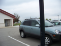
The Car in the parking lot during the service.
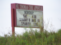
The Sign, saying when the service began.
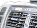
The Time when we arrived. The service is in session!
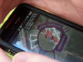
Victoire! We have arrived!
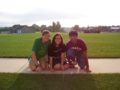
Our groupshot, with an inexplicably warm, heavenly glow.
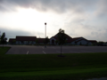
The Church, with a halo of light, possibly with a heavenly choir and flying cherubim.


Achievements
Bassoon, Dedehawk, and PainJain earned the Land geohash achievement
|
Bassoon, Dedehawk, and PainJain earned the Holy hash achievement
|
Bassoon and Dedehawk earned the Consecutive geohash achievement
|
Bassoon and Dedehawk achieved level 5 of the Minesweeper Geohash achievement
|
PainJain achieved level 1 of the Minesweeper Geohash achievement
|