Difference between revisions of "2010-08-16 54 13"
imported>Dawidi (just dumping the pictures and facts, will sort things out later) |
imported>Dawidi (→dawidi: picture sorting and captioning) |
||
| Line 7: | Line 7: | ||
== [[User:dawidi|dawidi]] == | == [[User:dawidi|dawidi]] == | ||
| − | had quite an eventful day getting to this geohash, and will tell more about it later | + | had quite an eventful day getting to this geohash, and will tell more about it later. |
<gallery> | <gallery> | ||
| − | File:2010-08-16 54 13 | + | File:2010-08-16 54 13 huegelgraeber.jpg|A field of burial mounds near Patzig. |
| − | File:2010-08-16 54 13 | + | File:2010-08-16 54 13 tower with internet.jpg|Griebke's lookout tower near Neuenkirchen. The internet was there :) |
| − | + | File:2010-08-16 54 13 holperweg.jpg|A bumpy avenue-ish field track that failed to get me to the coordinates. | |
| − | File:2010-08-16 54 13 | + | File:2010-08-16 54 13 strandwegweg.jpg|A grassy beach path that also failed. |
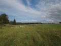
| − | + | File:2010-08-16 54 13 wet field.jpg|A field full of puddles that proved the only way to get there. | |
| − | File:2010-08-16 54 13 | + | File:2010-08-16 54 13 gps.jpg|Coordinates reached! |
| − | + | File:2010-08-16 54 13 grabenbeimhash.jpg|I was glad the hash was on ''this'' side. | |
| − | File:2010-08-16 54 13 | + | File:2010-08-16 54 13 hashwetter.jpg|Weather. |
| − | |||
| − | File:2010-08-16 54 13 | ||
| − | File:2010-08-16 54 13 | ||
| − | |||
| − | File:2010-08-16 54 13 | ||
| − | |||
</gallery> | </gallery> | ||
[[File:2010-08-16 54 13 hashpano without dawidi.jpg|thumb|640px|none|Panorama at the hashpoint]] | [[File:2010-08-16 54 13 hashpano without dawidi.jpg|thumb|640px|none|Panorama at the hashpoint]] | ||
| + | <gallery> | ||
| + | File:2010-08-16 54 13 harvested.jpg|Yup, that field has been harvested. | ||
| + | File:2010-08-16 54 13 harvesters.jpg|The picture I should not have taken. | ||
| + | File:2010-08-16 54 13 blackcarconvoy.jpg|Spooky black Mercedes convoy. | ||
| + | File:2010-08-16 54 13 cycleway.jpg|A wonderfully self-contradicting cycleway sign. | ||
| + | File:2010-08-16 54 13 brueckenpano1.jpg|The new Strelasund bridge after sunset. | ||
| + | File:2010-08-16 54 13 speicherstadt stralsund.jpg|Stralsund is a "storage town". | ||
| + | </gallery> | ||
[[Category:Expeditions]] | [[Category:Expeditions]] | ||
[[Category:Expeditions with photos]] | [[Category:Expeditions with photos]] | ||
[[Category:Coordinates reached]] | [[Category:Coordinates reached]] | ||
Revision as of 08:54, 31 August 2010
| Mon 16 Aug 2010 in 54,13: 54.5707954, 13.3459473 geohashing.info google osm bing/os kml crox |
In a harvested field northeast of Vieregge, in the not-very-touristy inner northern part of the island of Rügen.
dawidi
had quite an eventful day getting to this geohash, and will tell more about it later.
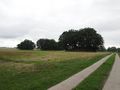
A field of burial mounds near Patzig.
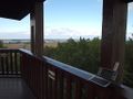
Griebke's lookout tower near Neuenkirchen. The internet was there :)
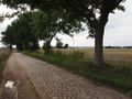
A bumpy avenue-ish field track that failed to get me to the coordinates.
A grassy beach path that also failed.
A field full of puddles that proved the only way to get there.
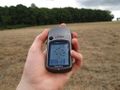
Coordinates reached!
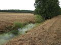
I was glad the hash was on this side.
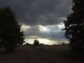
Weather.


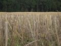
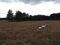
Yup, that field has been harvested.
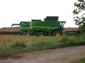
The picture I should not have taken.
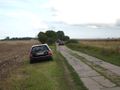
Spooky black Mercedes convoy.
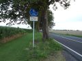
A wonderfully self-contradicting cycleway sign.
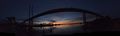
The new Strelasund bridge after sunset.
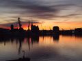
Stralsund is a "storage town".


