Difference between revisions of "2010-09-19 45 -122"
(restoring live message hidden inside a broken comment.) |
imported>Jiml (Finally adding report) |
||
| Line 21: | Line 21: | ||
== Participants == | == Participants == | ||
* [[User:Jiml|Jim]] | * [[User:Jiml|Jim]] | ||
| + | * [[User:Elegant Forkbomb|Elegant Forkbomb]] | ||
== Plans == | == Plans == | ||
| Line 27: | Line 28: | ||
| − | |||
== Expedition == | == Expedition == | ||
| − | |||
| − | + | === Elegant Forkbomb === | |
| + | |||
| + | *Walked the 2.16km to the hashpoint from my house. Took some pictures from the visitor's entrance side. -- Elegant Forkbomb, 00:06, 20 September 2010 | ||
| + | |||
| + | === Jim === | ||
| + | |||
| + | Well, I started out by heading for some brunch at a near by Dim Sum place. After that, I started | ||
| + | trying to program the GPS. However, I discovered that the batteries were pretty much dead. | ||
| + | |||
| + | Not a problem. I had put two spare, non-rechargeable batteries into my bag just a few days earlier | ||
| + | so I'd have some spares. I started replacing batteries, trying all the combinations. Still no luck. | ||
| + | |||
| + | Great: four dead batteries. However, there was a nearby store on the other side of the Nike campus | ||
| + | that I could get some new ones. A little driving later and I've got a working GPS and I'm | ||
| + | able to program it. | ||
| + | |||
| + | Now, I need to make my way to the hashpoint. I knew that part of the campus was used for fields for | ||
| + | various kids teams, and I was hoping maybe that part would be open, while the rest was closed, and | ||
| + | that the person on the phone was talking about the non-field part. | ||
| + | |||
| + | I found a public road to park along, and walked along past a child care center. Next to the | ||
| + | center was a pathway. I followed it, carefully inspecting all the signs for indications | ||
| + | that access wasn't allowed. The only sign was one saying that this was a wetland area, but I | ||
| + | was on a paved walkway, so that was just informational. | ||
| + | |||
| + | The walkway lead to a parking area and a bunch of kids waiting around, or loading gear into cars. | ||
| + | I continued towards the hashpoint, looking hard for that much-afeared signpost. But none | ||
| + | were to be found. I got to the field, and walked along another path, and found | ||
| + | the hashpoint under a tree. | ||
| + | |||
| + | I took a picture and headed home. | ||
| + | |||
| − | |||
| − | |||
| − | |||
| − | |||
== Photos == | == Photos == | ||
| − | |||
| − | |||
| − | |||
<gallery perrow="5"> | <gallery perrow="5"> | ||
| Line 54: | Line 77: | ||
</gallery> | </gallery> | ||
| − | + | ||
| + | |||
== Achievements == | == Achievements == | ||
{{#vardefine:ribbonwidth|800px}} | {{#vardefine:ribbonwidth|800px}} | ||
| − | |||
| + | * Land geohash | ||
| − | |||
| − | |||
| − | |||
| − | |||
| − | |||
[[Category:Expeditions]] | [[Category:Expeditions]] | ||
| − | + | ||
[[Category:Expeditions with photos]] | [[Category:Expeditions with photos]] | ||
| − | + | ||
| − | |||
| − | |||
| − | |||
| − | |||
[[Category:Coordinates reached]] | [[Category:Coordinates reached]] | ||
| − | |||
| − | |||
| − | |||
| − | |||
| − | |||
| − | |||
| − | |||
| − | |||
| − | |||
| − | |||
Revision as of 08:22, 3 October 2010
| Sun 19 Sep 2010 in 45,-122: 45.5101048, -122.8295401 geohashing.info google osm bing/os kml crox |
Location
Amid some trees near a huge field on the Nike Campus
Participants
Plans
Access may be a problem. I called Nike, and they said no access without an employee, so we may be stuck.
Expedition
Elegant Forkbomb
- Walked the 2.16km to the hashpoint from my house. Took some pictures from the visitor's entrance side. -- Elegant Forkbomb, 00:06, 20 September 2010
Jim
Well, I started out by heading for some brunch at a near by Dim Sum place. After that, I started trying to program the GPS. However, I discovered that the batteries were pretty much dead.
Not a problem. I had put two spare, non-rechargeable batteries into my bag just a few days earlier so I'd have some spares. I started replacing batteries, trying all the combinations. Still no luck.
Great: four dead batteries. However, there was a nearby store on the other side of the Nike campus that I could get some new ones. A little driving later and I've got a working GPS and I'm able to program it.
Now, I need to make my way to the hashpoint. I knew that part of the campus was used for fields for various kids teams, and I was hoping maybe that part would be open, while the rest was closed, and that the person on the phone was talking about the non-field part.
I found a public road to park along, and walked along past a child care center. Next to the center was a pathway. I followed it, carefully inspecting all the signs for indications that access wasn't allowed. The only sign was one saying that this was a wetland area, but I was on a paved walkway, so that was just informational.
The walkway lead to a parking area and a bunch of kids waiting around, or loading gear into cars. I continued towards the hashpoint, looking hard for that much-afeared signpost. But none were to be found. I got to the field, and walked along another path, and found the hashpoint under a tree.
I took a picture and headed home.
Photos
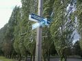
Endearingly geeky street names @45.4966,-122.8220
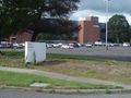
Industrial Parks of Beaverton @45.4966,-122.8220
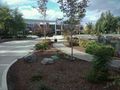
Formerly Massive Test Equipment Manufacturers of Beaverton @45.4996,-122.8230
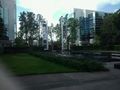
Hashpoint is on the far side of that building and across a pond @45.5053,-122.8050


Achievements
- Land geohash