Difference between revisions of "2010-11-07 52 1"
From Geohashing
imported>Sourcerer m |
imported>Sourcerer |
||
| Line 31: | Line 31: | ||
Image:2010-11-07-05-Google-Earth-Track.JPG|Google Earth Track | Image:2010-11-07-05-Google-Earth-Track.JPG|Google Earth Track | ||
</gallery> | </gallery> | ||
| + | |||
| + | == Other geohashing expeditions on the same day == | ||
| + | |||
| + | {{expedition summaries|2010-11-07}} | ||
[[Category:Expeditions with photos]] | [[Category:Expeditions with photos]] | ||
Revision as of 13:31, 22 November 2010
Contents
Location
Close to Sutton Corn Mill and the Weavers' Way long distance path, between the Norfolk Broads villages of Stalham and Hickling.
| Sun 7 Nov 2010 in Norwich: 52.7609772, 1.5510646 geohashing.info google osm bing/os kml crox |
Participants
Expedition
Sourcerer (Neil) extended a shopping trip to include this hashpoint. The hashpoint lay about 110 metres off the Weavers' Way long distance path. It could be reached by going round three sides of a newly planted field of what might have been wheat. The walk, including a diversion to look at the mill, was only 1.1 km long. It was a sunny November day and the temperature was about 8 Celsius.
Tracklog
The track is logged here at Wikiloc.
Photo Gallery
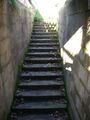
Unexpected Steps
Unexpected Steps
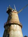
Sutton Corn Mill
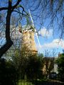
Sutton Corn Mill
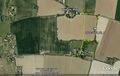
Google Earth Track


Other geohashing expeditions on the same day
Expeditions and Plans
| 2010-11-07 | ||
|---|---|---|
| Miami, Florida | Rhonda, Million zillion | In the middle of the road, in the Everglades. |
| Chur, Switzerland | Crox, Elisa | Parpan (Churwalden), Grisons, Switzerland |
| Norwich, United Kingdom | Sourcerer | Close to Sutton Corn Mill and the Weavers' Way long distance path, between ... |
| Sheffield, United Kingdom | myka, possibly Fergus | middleton park, south of leeds |
| Uppsala, Sweden | Vswe | Dalby outside Uppsala |
| Globalhash | Someone went | In the Hungary, Pecs graticule. *Google maps says it's in the middle of th... |