Difference between revisions of "2010-12-23 41 -90"
imported>Dvdllr m (Created page with '{{subst:Expedition |lat = 41 |lon = -90 |date = 2010-12-23 }}') |
imported>FippeBot m (Location) |
||
| (6 intermediate revisions by one other user not shown) | |||
| Line 1: | Line 1: | ||
| − | + | __NOTOC__ | |
| − | |||
| − | |||
| − | |||
| − | |||
| − | |||
| − | |||
| − | |||
| − | |||
| − | |||
{{meetup graticule | {{meetup graticule | ||
| lat=41 | | lat=41 | ||
| Line 14: | Line 5: | ||
| date=2010-12-23 | | date=2010-12-23 | ||
}} | }} | ||
| − | |||
| − | |||
| − | |||
== Location == | == Location == | ||
| − | + | The verge between two roads in Bettendorf, Iowa | |
== Participants == | == Participants == | ||
| − | + | * [[User:Dvdllr|Dvdllr]] | |
| + | * Near-at-hand: Rachel and Marvin | ||
== Plans == | == Plans == | ||
| − | + | The first leg of my family's Christmastime travels was from [[40,-89]] to [[42,-91]], and in advance of this drive, I checked the geohash locations for the five graticules we'd intersect. Happenstance was that in the Quad Cities grat, specifically the Bettendorf portion, the hashpoint was just off of Interstate 74, which made for an easy grab. I simply planned to take this minor detour while passing through. | |
== Expedition == | == Expedition == | ||
| − | + | The expedition went off without a hitch. The two roads that the hashpoint lay between were a kind of busy road, not conducive to stopping alongside, and a residential road, ''very'' conducive to stopping alongside. Our GPS guided me to the residential road, and I parked where I thought I was orthagonal to the hashpoint. I ended up being a little too far down the road from where I needed to be, but it was still fine. The verge was a bit of a slope, and given the snowy conditions, slippery. I managed not to wipe out, so that was positive. I was pleased to find that I could get my GPS to line up its coordinates with the destination relatively accurately, so when I was standing in the right spot, I did a little snow art to mark the location. I wrote "xkcd" in the snow (with my hand), and attempted to make a tiny snowman. It ended up being two snowballs stacked atop each other, with eye and nose holes poked into the top one. I was rather limited in my equipment to make something better, since there weren't any rocks or sticks to avail me. | |
| − | == | + | Like the last time I claimed the Frozen Geohash award, I didn't have a thermometer with me. But like last time, I can see from [http://www.wunderground.com/history/airport/KDVN/2010/12/23/DailyHistory.html?req_city=Bettendorf&req_state=IA&req_statename=Iowa here] that the high for the day was -2.8°C, so it was most decidedly below freezing while I was there. |
| − | |||
== Photos == | == Photos == | ||
| − | |||
| − | |||
| − | |||
<gallery perrow="5"> | <gallery perrow="5"> | ||
| + | Image:2010-12-23 41 -90 1.JPG | Looking for where to be | ||
| + | Image:2010-12-23 41 -90 2.JPG | Coming back down for the camera | ||
| + | Image:2010-12-23 41 -90 3.JPG | Got it | ||
| + | Image:2010-12-23 41 -90 4.JPG | Geohashing partners | ||
| + | Image:2010-12-23 41 -90 5.JPG | Geohasher | ||
| + | Image:2010-12-23 41 -90 6.JPG | xkcd | ||
| + | Image:2010-12-23 41 -90 7.JPG | Miniature snowman | ||
| + | Image:2010-12-23 41 -90 8.JPG | Impaled with a flag | ||
| + | Image:2010-12-23 41 -90 9.JPG | Canine geohasher | ||
</gallery> | </gallery> | ||
== Achievements == | == Achievements == | ||
{{#vardefine:ribbonwidth|800px}} | {{#vardefine:ribbonwidth|800px}} | ||
| − | + | {{land geohash | |
| + | | latitude = 41 | ||
| + | | longitude = -90 | ||
| + | | date = 2010-12-23 | ||
| + | | name = [[User:Dvdllr|Dvdllr]] | ||
| + | }} | ||
| + | {{snowman geohash | ||
| − | + | | latitude = 41 | |
| − | + | | longitude = -90 | |
| − | [[ | + | | date = 2010-12-23 |
| + | | name = [[User:Dvdllr|Dvdllr]] | ||
| + | }} | ||
| + | {{Frozen Geohash | ||
| − | + | | latitude = 41 | |
| − | + | | longitude = -90 | |
| − | [[ | + | | date = 2010-12-23 |
| − | -- | + | | name = [[User:Dvdllr|Dvdllr]] |
| + | }} | ||
| + | {{xkcd-100-Honorable-Mention | ||
| + | | latitude = 41 | ||
| + | | longitude = -90 | ||
| + | | date = 2010-12-23 | ||
| + | | distance = 106 miles | ||
| + | | name = [[User:Dvdllr|Dvdllr]] | ||
| + | }} | ||
| + | {{A Tale of Two Hashes challenge | ||
| + | | latitude = 41 | ||
| + | | longitude = -90 | ||
| + | | date = 2010-12-23 | ||
| + | | name = [[User:Dvdllr|Dvdllr]] | ||
| + | | place = [http://en.wikipedia.org/wiki/Bettendorf Bettendorf] | ||
| + | }} | ||
| − | |||
[[Category:Expeditions]] | [[Category:Expeditions]] | ||
| − | |||
[[Category:Expeditions with photos]] | [[Category:Expeditions with photos]] | ||
| − | |||
| − | |||
| − | |||
| − | |||
| − | |||
[[Category:Coordinates reached]] | [[Category:Coordinates reached]] | ||
| − | + | [[Category:Expeditions with dogs]] | |
| − | + | {{location|US|IA|SC}} | |
| − | |||
| − | [[Category: | ||
| − | |||
| − | |||
| − | |||
| − | |||
| − | |||
| − | |||
Latest revision as of 05:01, 9 August 2019
| Thu 23 Dec 2010 in 41,-90: 41.5311194, -90.5170151 geohashing.info google osm bing/os kml crox |
Location
The verge between two roads in Bettendorf, Iowa
Participants
- Dvdllr
- Near-at-hand: Rachel and Marvin
Plans
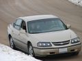
The first leg of my family's Christmastime travels was from 40,-89 to 42,-91, and in advance of this drive, I checked the geohash locations for the five graticules we'd intersect. Happenstance was that in the Quad Cities grat, specifically the Bettendorf portion, the hashpoint was just off of Interstate 74, which made for an easy grab. I simply planned to take this minor detour while passing through.
Expedition
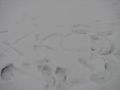
The expedition went off without a hitch. The two roads that the hashpoint lay between were a kind of busy road, not conducive to stopping alongside, and a residential road, very conducive to stopping alongside. Our GPS guided me to the residential road, and I parked where I thought I was orthagonal to the hashpoint. I ended up being a little too far down the road from where I needed to be, but it was still fine. The verge was a bit of a slope, and given the snowy conditions, slippery. I managed not to wipe out, so that was positive. I was pleased to find that I could get my GPS to line up its coordinates with the destination relatively accurately, so when I was standing in the right spot, I did a little snow art to mark the location. I wrote "xkcd" in the snow (with my hand), and attempted to make a tiny snowman. It ended up being two snowballs stacked atop each other, with eye and nose holes poked into the top one. I was rather limited in my equipment to make something better, since there weren't any rocks or sticks to avail me.
Like the last time I claimed the Frozen Geohash award, I didn't have a thermometer with me. But like last time, I can see from here that the high for the day was -2.8°C, so it was most decidedly below freezing while I was there.
Photos
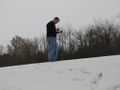
Looking for where to be
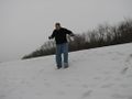
Coming back down for the camera
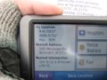
Got it
Geohashing partners

Geohasher
xkcd
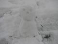
Miniature snowman
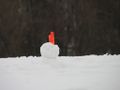
Impaled with a flag
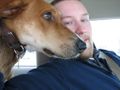
Canine geohasher


Achievements
Dvdllr earned the Land geohash achievement
|
Dvdllr earned the Snowman Geohash Achievement
|
Dvdllr earned the Frozen Geohash Achievement
|
Dvdllr earned the XKCD-100 Honorable Mention Achievement
|
Dvdllr issued a challenge for the Tale of Two Hashes achievement
|