Difference between revisions of "2011-03-20 52 0"
imported>Sourcerer (Created page with "== Location == In a Thetford Forest field about a mile west of the Elveden Center Parcs holiday centre west of Thetford, Norfolk, UK. {{meetup graticule | lat=52 | lon=...") |
imported>Sourcerer |
||
| Line 1: | Line 1: | ||
== Location == | == Location == | ||
| − | In a | + | Multihash 4 of 5. In a field about a mile west of the Elveden Center Parcs holiday centre west of Thetford, Norfolk, UK. |
{{meetup graticule | {{meetup graticule | ||
| Line 16: | Line 16: | ||
== Expedition == | == Expedition == | ||
| − | + | In deep twilight, Neil reached hashpoint four of a five point multihash. The walk to the hashpoint was through a small part of Thetford Forest. The moon had not yet risen so it became quite dark. The path skirted the boundary of the Center Parcs holiday centre. The site was fenced to prison camp standards. Inside it looked nice though, with chalets lit up for the evening. | |
| − | + | After the holiday village, there was a stile giving access to a large field. In the field, there were quite a lot of bullocks (young male cows). They seemed quite nervous but kept clear of Neil's path. The hashpoint was near the further boundary of the field so the bullocks had to be negotiated twice. This was probably not dangerous. The only recent fatalities involving cows were all because mothers were protecting their young. Is there an award for getting youself killed whilst geohahsing? If you were silly enough, a Darwin award would be good. | |
== Photo Gallery == | == Photo Gallery == | ||
<gallery perrow="3"> | <gallery perrow="3"> | ||
| − | Image:2011-03- | + | Image:2011-03-20_52_0_Sourcerer_1.jpg|Google Earth Vieew of the Walk |
| − | |||
</gallery> | </gallery> | ||
| Line 32: | Line 31: | ||
== Achievements == | == Achievements == | ||
| + | |||
| + | {{gratuitous ribbon | ||
| + | | color = orange | ||
| + | | icon = Ate_at_myponga.png | ||
| + | | latitude = 52 | ||
| + | | longitude = 1 | ||
| + | | date = 2011-03-20 | ||
| + | | achievement = Stealth Geohash | ||
| + | | description = arriving unobserved under cover of darkness. | ||
| + | | name = Sourcerer | ||
| + | }} | ||
[[Category:Expeditions with photos]] | [[Category:Expeditions with photos]] | ||
| − | |||
[[Category:Coordinates reached]] | [[Category:Coordinates reached]] | ||
[[Category:Meetup on 2011-03-20]] | [[Category:Meetup on 2011-03-20]] | ||
[[Category:Meetup in 52 0]] | [[Category:Meetup in 52 0]] | ||
Revision as of 22:42, 21 March 2011
Contents
Location
Multihash 4 of 5. In a field about a mile west of the Elveden Center Parcs holiday centre west of Thetford, Norfolk, UK.
| Sun 20 Mar 2011 in Cambridge: 52.3877725, 0.6268758 geohashing.info google osm bing/os kml crox |
Participants
Expedition
In deep twilight, Neil reached hashpoint four of a five point multihash. The walk to the hashpoint was through a small part of Thetford Forest. The moon had not yet risen so it became quite dark. The path skirted the boundary of the Center Parcs holiday centre. The site was fenced to prison camp standards. Inside it looked nice though, with chalets lit up for the evening.
After the holiday village, there was a stile giving access to a large field. In the field, there were quite a lot of bullocks (young male cows). They seemed quite nervous but kept clear of Neil's path. The hashpoint was near the further boundary of the field so the bullocks had to be negotiated twice. This was probably not dangerous. The only recent fatalities involving cows were all because mothers were protecting their young. Is there an award for getting youself killed whilst geohahsing? If you were silly enough, a Darwin award would be good.
Photo Gallery
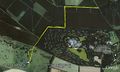
Google Earth Vieew of the Walk

Other Geohashing Expeditions and Plans on This Day
Expeditions and Plans
| 2011-03-20 | ||
|---|---|---|
| Varna, Bulgaria | Kisolre | In a ex corn field near Voivodino village. |
| Mannheim, Germany | ilpadre, fivetonsofflax, Euterkuh, Mampfred, LadyBB | In a field south of Eppelheim. |
| Schweinfurt, Germany | Reinhard | On a field at the foot of the "Großen Gleichberg" (big equal mountain). |
| Halle (Saale), Germany | Rincewind, Yakamoz | For a change, the hashpoint was on a field near Querfurt. |
| Northampton, United Kingdom | Sourcerer | Multihash 3 of 5. In a field at Twywell Hills and Dales, about 4.5 miles ea... |
| Birmingham, United Kingdom | Sourcerer | Multihash 2 of 5. In a field about five miles west of Coventry, UK. 2011-03-20 53 -1 ::2011-03-20 52 -1 ::... |
| Cambridge, United Kingdom | Sourcerer | Multihash 4 of 5. In a field about a mile west of the Elveden Center Parcs ... |
| Norwich, United Kingdom | Sourcerer | Multihash 5 of 5. In a field north west of Frostenden, two miles west of Wr... |
| Sheffield, United Kingdom | Sourcerer | Multihash 1 of 5. In a field north of the A57 at Hollow Meadows about seven... |
| Vantaa, Finland | small oaks | The coordinates were in a private yard roughly 50 m off the spot I managed ... |
Achievements
Sourcerer earned the Stealth Geohash
|