Difference between revisions of "2011-04-23 51 11"
imported>TheOneRing |
imported>TheOneRing (→TheOneRing) |
||
| Line 26: | Line 26: | ||
Image:20110423Surrounding1.jpg|The view eastwards... | Image:20110423Surrounding1.jpg|The view eastwards... | ||
Image:20110423Surrounding2.jpg|...and westwards with a village in the background | Image:20110423Surrounding2.jpg|...and westwards with a village in the background | ||
| − | Image:20110423DragAlongs.jpg|My parents wondering what I'm doing | + | Image:20110423DragAlongs.jpg|My parents wondering what I'm doing (and why they are doing it, too ;-) |
</gallery> | </gallery> | ||
Revision as of 18:56, 26 April 2011
| Sat 23 Apr 2011 in 51,11: 51.2925429, 11.7866347 geohashing.info google osm bing/os kml crox |
Contents
Location
The geohash is on a field near the village of St. Micheln.
Who Went
TheOneRing - by car.
The parents of TheOneRing.
The Expedition
TheOneRing
While I spent the Easter holidays at my parents' the geohash of today was not far away. So my parents and I took the car and drove as close as possible to the geohash. From there we had just approx. 600m to walk.
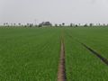
The geohash itself was again on a field (like last time) and - again - the plants were small so I dont't know what was cultivated there.
Shaking their heads about my hobby we waited till past 4 o'clock, but no one showed up, and we drove back home by passing the Geiseltalsee, an artificial lake which replaces a former opencast pit.
Photos
TheOneRing
There must be the geohash...anywhere
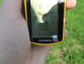
There! The proof

Stupid Grin while looking into the Sun
The view eastwards...
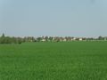
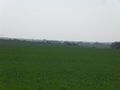
...and westwards with a village in the background
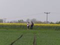
My parents wondering what I'm doing (and why they are doing it, too ;-)


Achievements
TheOneRing earned the Land geohash achievement
|
TheOneRing earned the xkcd Nullaturion achievement
|
TheOneRing earned the Drag-along achievement
|