Difference between revisions of "2011-04-23 51 11"
imported>TheOneRing (→TheOneRing) |
imported>TheOneRing (→TheOneRing) |
||
| Line 23: | Line 23: | ||
Image:20110423Geohash1.jpg|There must be the geohash...anywhere | Image:20110423Geohash1.jpg|There must be the geohash...anywhere | ||
Image:20110423GPS.jpg|There! The proof | Image:20110423GPS.jpg|There! The proof | ||
| − | Image:20110423Me.jpg|Stupid Grin while looking into the Sun | + | Image:20110423Me.jpg|Stupid Grin while looking into the Sun (out car in the background) |
Image:20110423Surrounding1.jpg|The view eastwards... | Image:20110423Surrounding1.jpg|The view eastwards... | ||
Image:20110423Surrounding2.jpg|...and westwards with a village in the background | Image:20110423Surrounding2.jpg|...and westwards with a village in the background | ||
Revision as of 17:28, 30 April 2011
| Sat 23 Apr 2011 in 51,11: 51.2925429, 11.7866347 geohashing.info google osm bing/os kml crox |
Contents
Location
The geohash is on a field near the village of St. Micheln.
Who Went
TheOneRing - by car.
The parents of TheOneRing.
The Expedition
TheOneRing
While I spent the Easter holidays at my parents' the geohash of today was not far away. So my parents and I took the car and drove as close as possible to the geohash. From there we had just approx. 600m to walk.
The geohash itself was again on a field (like last time) and - again - the plants were small so I dont't know what was cultivated there.
My parents shook their heads about my hobby. We waited till past 4 o'clock, but no one showed up, and we drove back home by passing the Geiseltalsee, an artificial lake which replaces a former opencast pit.
Photos
TheOneRing
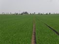
There must be the geohash...anywhere
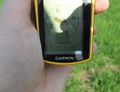
There! The proof

Stupid Grin while looking into the Sun (out car in the background)
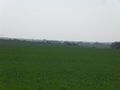
The view eastwards...
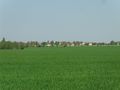
...and westwards with a village in the background
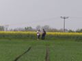
My parents wondering what I'm doing (and why they are doing it, too ;-)


Achievements
TheOneRing earned the Land geohash achievement
|
TheOneRing earned the xkcd Nullaturion achievement
|
TheOneRing earned the Drag-along achievement
|