Difference between revisions of "2011-05-07 45 -122"
From Geohashing
imported>Michael5000 m |
imported>Michael5000 |
||
| Line 1: | Line 1: | ||
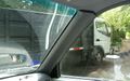
| − | [[File:2011-05-07 Truck.JPG|right|400px]] | + | [[File:2011-05-07 Truck.JPG|thumb|right|400px|There is a landscaper's truck sits aslant the hashpoint.]] |
{{meetup graticule | {{meetup graticule | ||
| Line 32: | Line 32: | ||
--> | --> | ||
<gallery perrow="5"> | <gallery perrow="5"> | ||
| + | File:2011-05-07 Truck.JPG|Truck atop hashpoint. | ||
</gallery> | </gallery> | ||
| Line 39: | Line 40: | ||
| − | |||
| − | |||
| − | |||
| − | |||
| − | |||
| − | |||
| − | |||
| − | |||
| − | |||
| − | |||
[[Category:Expeditions]] | [[Category:Expeditions]] | ||
| − | |||
[[Category:Expeditions with photos]] | [[Category:Expeditions with photos]] | ||
| − | |||
| − | |||
| − | |||
| − | |||
| − | |||
[[Category:Coordinates reached]] | [[Category:Coordinates reached]] | ||
| − | |||
| − | |||
| − | |||
| − | |||
| − | |||
| − | |||
| − | |||
| − | |||
| − | |||
| − | |||
Revision as of 21:22, 7 May 2011

| Sat 7 May 2011 in 45,-122: 45.4425543, -122.6903141 geohashing.info google osm bing/os kml crox |
Location
A suburban street off of Scholls Ferry Road.
Participants
Plans
Expedition
On the way back from a running event in Forest Grove, I let the GPS guide me around the maze of suburban streets west of Lewis and Clark College. The hashpoint was at the end of a dead end street, just where it split into private driveways. There was a landscaper's truck parked on top of it; I suppose I could have crawled underneath it if I were persnickity, but I take a practical view of these matters and declared victory instead.
Tracklog
Photos
Truck atop hashpoint.