Difference between revisions of "2011-06-13 47 8"
imported>TheOneRing |
imported>TheOneRing (→Achievements) |
||
| Line 39: | Line 39: | ||
== Achievements == | == Achievements == | ||
| + | {{land geohash | latitude = 47 | longitude = 8 | date = 2011-06-13 | name = TheOneRing }} | ||
| + | {{Public transport geohash | latitude = 47 | longitude = 8 | date = 2011-06-13 | name = TheOneRing}} | ||
| + | {{Border geohash achievement | latitude = 47 | longitude = 8 | date = 2011-06-13 | country1= Switzerland | country2= Germany | name = TheOneRing }} | ||
| + | {{Reverse regional | latitude = 47 | longitude = 8 | name = ThOneRing | count = 2 | graticule = Zürich, Switzerland | level = country }} | ||
| − | [[Category: | + | [[Category:Expeditions]] |
| + | [[Category:Expeditions with photos]] | ||
| + | [[Category:Coordinates reached]] | ||
Revision as of 17:23, 13 June 2011
| Mon 13 Jun 2011 in 47,8: 47.7056104, 8.6781947 geohashing.info google osm bing/os kml crox |
Contents
Location
Büsingen am Hochrhein is a German exclave, a German village but completely surrounded by Switzerland.
Participants
- Ekorren tries to get there, ETA about 9:15-9:30
- TheOneRing - by public transport
Expedition
TheOneRing
I decided at quite short notice, but I didn't want to miss the opportunity to visit this point. Unfortunately I didn't check this site before, otherwise I could have coordinated with Ekorren.
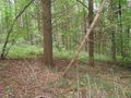
I left Berne around 11 o'clock and arrived at Herblingen near the geohash at 1 o'clock. Then there were only 1.5 km to walk, which was good, because the weather didn't look very promising. After a while I reached the Swiss-German border, which didn't look like a border at all. There was only a sign which marked the border line.
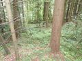
The geohash itself was quite easy to reach, it was in a forest but near the trail. I took the usual photographs and walked then back to the train station. Sometimes it rained a little bit, sometimes the Sun was shining. Confusing, I didn't know what to wear: a jacket or even take my pullover off.
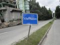
There was a little bit of time while changing trains, so I walk through Schaffhausen and then got back to Berne. All in all it was very nice.
Gallery
TheOneRing
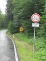
Swiss-German border, nothing but a sign
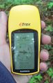
Proof that I reached the right coordinates...
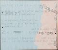
...on the right date
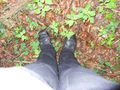
My boots marks the geohash
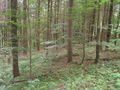
View SE,...
... NW,...
... and NE from the geohash
Back to Switzerland
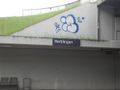
The train station of Herblingen (unfortunately with a graffito)
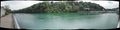
Panoramic view of the river Rhine in Schaffhausen


Achievements
TheOneRing earned the Land geohash achievement
|
TheOneRing earned the Public transport geohash achievement
|
TheOneRing earned the Border geohash achievement
|
ThOneRing earned the Reverse regional achievement
|