Difference between revisions of "2011-07-19 48 12"
imported>Dawidi (mini-writeup and photos) |
imported>FippeBot m (Location) |
||
| Line 23: | Line 23: | ||
[[Category:Expeditions with photos]] | [[Category:Expeditions with photos]] | ||
[[Category:Coordinates reached]] | [[Category:Coordinates reached]] | ||
| + | {{location|DE|BY|R|city=true}} | ||
Latest revision as of 00:10, 13 August 2019
| Tue 19 Jul 2011 in Landshut, Germany: 48.9844916, 12.0788194 geohashing.info google osm bing/os kml crox |
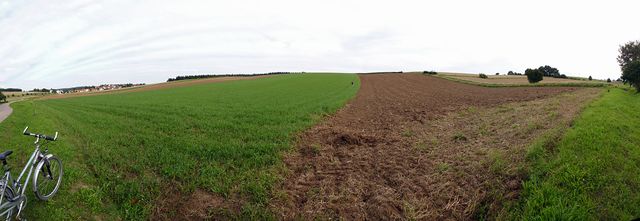
In a meadow near Grass, just south of Regensburg
Tomcat and dawidi
... decided to go there, during a phone call just minutes after hash o'clock the previous day, and the plans for the rest of the evening grew easily around that seed.
They met near Regensburg's central station after work, found an easy mystery geocache in town, bought some bread, quickly (and rather uneventfully) visited and documented the hashpoint, found another, somewhat more difficult mystery cache near a (previously unknown) little pond, and then cycled on to Tomcat's place to turn the bread into dinner.
The exact coordinates looked like the edge between two fields on satellite imagery, but one of them turned out to be a meadow - very fitting for a hashpoint to fall into the grass near Grass.


