Difference between revisions of "2011-08-16 52 1"
From Geohashing
imported>Sourcerer ([live picture] Arrived. [http://www.openstreetmap.org/?lat=52.56362557411194&lon=1.2262040376663208&zoom=16&layers=B000FTF @52.5636,1.2262]) |
imported>Jiml m (Adjust result codes) |
||
| Line 1: | Line 1: | ||
| − | |||
<!-- If you did not specify these parameters in the template, please substitute appropriate values for IMAGE, LAT, LON, and DATE (YYYY-MM-DD format) | <!-- If you did not specify these parameters in the template, please substitute appropriate values for IMAGE, LAT, LON, and DATE (YYYY-MM-DD format) | ||
| Line 52: | Line 51: | ||
[[Category:New report]] | [[Category:New report]] | ||
| − | + | [[Category:Expeditions]] | |
| − | |||
| − | [[Category: | ||
| − | |||
| − | |||
| − | |||
| − | |||
[[Category:Expeditions with photos]] | [[Category:Expeditions with photos]] | ||
| − | |||
| − | |||
| − | |||
| − | |||
| − | |||
[[Category:Coordinates reached]] | [[Category:Coordinates reached]] | ||
| − | |||
| − | |||
| − | |||
| − | |||
| − | |||
| − | |||
| − | |||
| − | |||
| − | |||
| − | |||
Revision as of 15:21, 16 August 2011
| Tue 16 Aug 2011 in 52,1: 52.5636154, 1.2262501 geohashing.info google osm bing/os kml crox |
Location
Participants
Plans
Expedition
- Arrived. -- Sourcerer @52.5636,1.2262 11:08, 16 August 2011 (GMT+01:00)
Tracklog
Photos
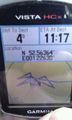
Arrived. @52.5636,1.2262
