Difference between revisions of "2011-09-03 45 -122"
imported>Kydlt (Created page with "My plan is going to the Skamania Elementry School ballfield's deep center field. I'm running out of time, so I'll fix up the page later. If I don't go there on the way to my gr...") |
imported>FippeBot m (Location) |
||
| (6 intermediate revisions by 2 users not shown) | |||
| Line 1: | Line 1: | ||
| − | My plan is going to the Skamania Elementry School ballfield's deep center field. | + | <!-- If you did not specify these parameters in the template, please substitute appropriate values for IMAGE, LAT, LON, and DATE (YYYY-MM-DD format) |
| + | |||
| + | [[Image:{{{image|IMAGE}}}|thumb|left]] | ||
| + | |||
| + | Remove this section if you don't want an image at the top (left) of your report. You should remove the "Image:" or "File:" | ||
| + | tag from your image file name, and replace the all upper-case word IMAGE in the above line. | ||
| + | |||
| + | And DON'T FORGET to add your expedition and the best photo you took to the gallery on the Main Page! We'd love to read your report, but that means we first have to discover it! | ||
| + | --> | ||
| + | {{meetup graticule | ||
| + | | lat=45 | ||
| + | | lon=-122 | ||
| + | | date=2011-09-03 | ||
| + | }} | ||
| + | |||
| + | |||
| + | __NOTOC__ | ||
| + | == Location == | ||
| + | Near Skamania Elementry School | ||
| + | |||
| + | == Participants == | ||
| + | * [[User:kydlt|kydlt]] | ||
| + | |||
| + | == Plans == | ||
| + | My plan is going to the Skamania Elementry School ballfield's deep center field. I'm running out of time, so I'll fix up the page later. If I don't go there on the way to my granddaughter's b'day I will on the way home. kydlt | ||
| + | |||
| + | |||
| + | == Expeditions == | ||
| + | |||
| + | === Expedition: morning=== | ||
| + | |||
| + | I rushed by on the drive in to P's dance recital before her b'day party. The school is right on my way if I go in WA 14. But the gates were locked. | ||
| + | |||
| + | How can they lock up a school ball diamond on a sunny Saturday ?!? But here is where I messed up. | ||
| + | |||
| + | I went to the back corner, by deep center field, to get as close as I could and maybe find a break in the fence. | ||
| + | |||
| + | I left a marker and took photos. But with the glare, and my rushed state of mind, couldn't see the GPS display clearly. I just went to where Google map made it look like I should go. | ||
| + | |||
| + | Then now, processing photos, it seems Google lied (No surprise really) and maybe I made it, or could have. | ||
| + | |||
| + | So check the track log. AAARGH, I didn't turn it on. | ||
| + | NEVER RUSH | ||
| + | ! | ||
| + | Maybe I can go by on the way home. If it isn't dark. | ||
| + | |||
| + | kydkt | ||
| + | |||
| + | === Expedition: evening === | ||
| + | |||
| + | OK, I did better on the way home, HOWEVER the fence was still in the way. | ||
| + | |||
| + | I feel that if I waited for poorer satellite geometry I would have been there. I.e., the hash was just outside of my GDOP. | ||
| + | |||
| + | But I felt so much better going back and correcting my glaring morning mistake. | ||
| + | |||
| + | == Photos == | ||
| + | |||
| + | <gallery perrow="5"> | ||
| + | |||
| + | File:2011-09-03 45 -122 school.jpg|The school was where it should be. | ||
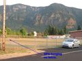
| + | File:2011-09-03 45 -122 locked.jpg | But the yard was locked up. | ||
| + | File:2011-09-03 45 -122 denighed.jpg | So I left my flag close to where I guessed the hash was. | ||
| + | File:2011-09-03 45 -122 rushed.jpg | But when I got inside and could see, the GPS showes it back at the street corner. My track log would prove that I was there. But alas, I wasn't tracking. A poorly done trip. | ||
| + | File:2011-09-03 45 -122 30 ft.jpg|Just the other side of the fence, just out of my GDOP circle. | ||
| + | File:2011-09-03 45 -122 left field foul line.jpg|Not deep center as I thought, but the end of the left foul line. And I'm playing with drawing on photos. | ||
| + | File:2011-09-03 45 -122 track capture.JPG|The track file displayed on Topo8, overlayed on DOQQ. | ||
| + | </gallery> | ||
| + | |||
| + | == Achievements == | ||
| + | |||
| + | *Land Geohash | ||
| + | |||
| + | [[Category:Expeditions]] | ||
| + | [[Category:Expeditions with photos]] | ||
| + | |||
| + | [[Category:Coordinates reached]] | ||
| + | {{location|US|WA|SM}} | ||
Latest revision as of 00:44, 13 August 2019
| Sat 3 Sep 2011 in 45,-122: 45.6181910, -122.0483631 geohashing.info google osm bing/os kml crox |
Location
Near Skamania Elementry School
Participants
Plans
My plan is going to the Skamania Elementry School ballfield's deep center field. I'm running out of time, so I'll fix up the page later. If I don't go there on the way to my granddaughter's b'day I will on the way home. kydlt
Expeditions
Expedition: morning
I rushed by on the drive in to P's dance recital before her b'day party. The school is right on my way if I go in WA 14. But the gates were locked.
How can they lock up a school ball diamond on a sunny Saturday ?!? But here is where I messed up.
I went to the back corner, by deep center field, to get as close as I could and maybe find a break in the fence.
I left a marker and took photos. But with the glare, and my rushed state of mind, couldn't see the GPS display clearly. I just went to where Google map made it look like I should go.
Then now, processing photos, it seems Google lied (No surprise really) and maybe I made it, or could have.
So check the track log. AAARGH, I didn't turn it on. NEVER RUSH ! Maybe I can go by on the way home. If it isn't dark.
kydkt
Expedition: evening
OK, I did better on the way home, HOWEVER the fence was still in the way.
I feel that if I waited for poorer satellite geometry I would have been there. I.e., the hash was just outside of my GDOP.
But I felt so much better going back and correcting my glaring morning mistake.
Photos

The school was where it should be.
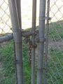
But the yard was locked up.
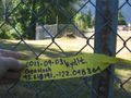
So I left my flag close to where I guessed the hash was.
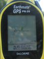
But when I got inside and could see, the GPS showes it back at the street corner. My track log would prove that I was there. But alas, I wasn't tracking. A poorly done trip.
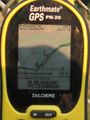
Just the other side of the fence, just out of my GDOP circle.
Not deep center as I thought, but the end of the left foul line. And I'm playing with drawing on photos.
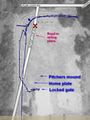
The track file displayed on Topo8, overlayed on DOQQ.


Achievements
- Land Geohash