Difference between revisions of "2011-09-19 44 -117"
imported>Michael5000 m (→Achievements) |
imported>Michael5000 m (→Photos) |
||
| Line 40: | Line 40: | ||
File:2011-09-19 44 -117 signs.JPG|"Heavy Truck Traffic" and "Speed 20 MPH" really makes a guy pay attention to a subtle "No Trespassing." | File:2011-09-19 44 -117 signs.JPG|"Heavy Truck Traffic" and "Speed 20 MPH" really makes a guy pay attention to a subtle "No Trespassing." | ||
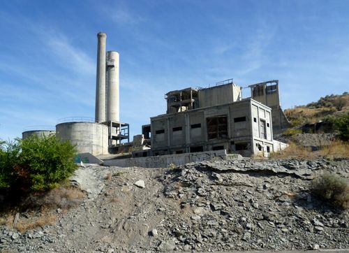
File:2011-09-19 44 -117 more ruins.JPG|So, I took pictures of the industrial ruins instead. | File:2011-09-19 44 -117 more ruins.JPG|So, I took pictures of the industrial ruins instead. | ||
| + | File:2011-09-19 44 -117 main.JPG|Pretty good ruins for this part of the world. | ||
</gallery> | </gallery> | ||
Revision as of 17:15, 26 September 2011
| Mon 19 Sep 2011 in 44,-117: 44.4223289, -117.2688817 geohashing.info google osm bing/os kml crox |
Location
In the hills east of the industrial ruins at Lime.
Participants
Expedition
Prologue to 2011-09-19
This day was intended to be the sixth and final day of a fall vacation. I woke up in Baker City, Oregon, and checked to see if there were any potentially accessible hashpoints in the usually difficult Eastern Oregon terrain. And it was weird: almost ALL of them were accessible. Out of 13 I checked, ten looked like they had reasonable to excellent chances of accessibility. The chance of reaping such a harvest was eye-catching enough that I got buy-in from Mrs.5000 to extend my trip for an extra day, thus letting me try for six Expeditions on 2011-09-19 (I would succeed in four and be thwarted twice) and setting me up to try for the Endurance Geohashing achievement on 2011-09-20 (I would succeed).
The Expedition
I backtracked from Baker City to the defunct industrial site of Lime, Oregon; the hashpoint was located a short hike off of an access road leading up from near a freeway exit. But when I arrived at the base of the access road, I found the area choked with industrial equipment and windmill components, with discouraging signs posted.
Spotting two workmen, I rolled down my window and asked "is this a public road?" The guy who came over to talk to me turned out to be an apologetic, good-natured Dane, not melancholy but perhaps too much in the sun to judge from his burnt face and arms. Probably feeling a little shy about exerting authority quite so far off his own patch, he explained that "the owner" really wanted to keep traffic off the (narrow, gravel) road while the trucks carrying the large windmill components were wending their way back and forth. Even by geohashing standards, this seemed like a reasonable request. Expedition Twarted.
I asked the technician how he was liking Oregon, and pointed out through wavy hand gestures that the topography was probably a little more extreme than he was used to. He agreed emphatically, and seemed dazzled by my ability to just know that he was from Denmark until I pointed out that his work t-shirt said something along the lines of "dansk aero-energie."
The ruins of an old cement factory at Lime are one of the most notable landmarks on I-84 in Eastern Oregon, so since I was there I spent a few minutes taking pictures of them before taking a long, lonely one-lane gravel road (The Malheur Line Road, I think it was called) towards Highway 26 and five more hashpoints.
Photos
Achievements
- This was the first attempt (by anyone) at a hashpoint in the Baker City, Oregon graticule.
- Seventh Expedition of the Endurance Geohashing series.
Michael5000 earned the No trespassing consolation prize
|
Michael5000 earned the Multihash Achievement
|
- Six attempts and four successes in one long day.


