Difference between revisions of "2011-10-09 45 -122"
imported>Michael5000 (→Photos) |
imported>Michael5000 (→Achievements) |
||
| Line 71: | Line 71: | ||
[[Category:Expedition planning]] | [[Category:Expedition planning]] | ||
| − | |||
| − | |||
[[Category:Expeditions]] | [[Category:Expeditions]] | ||
| − | |||
[[Category:Expeditions with photos]] | [[Category:Expeditions with photos]] | ||
| − | |||
| − | |||
| − | |||
| − | |||
| − | |||
[[Category:Coordinates reached]] | [[Category:Coordinates reached]] | ||
| − | |||
<!-- or if you failed :( | <!-- or if you failed :( | ||
Revision as of 20:09, 9 October 2011
| Sun 9 Oct 2011 in 45,-122: 45.4032732, -122.6177873 geohashing.info google osm bing/os kml crox |
Location
A roadway near 99E between Milwaukie and Gladstone.
Participants
- Michael5000
- Mrs.5000
- Niece #2
Plans
Looks accessible, and I'll be in Portland at the bloodbank on Sunday, so I'll be somewhat nearby.... Kydlt might make it in the evening, I won't be in Portland until later.
Expedition
5000
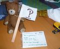
We picked up Niece #2 at approximately 0945 hours and proceeded southward via McLaughlin Blvd and Highway 99E to a residential area between Milwaukie and Gladstone. The hashpoint was within an arm's length of the sidewalk, on a landscaped slope at the periphery of an apartment or assisted living complex. We were all essentially there; the Bear (being our trusty hashscot, of course) was able to be thoroughly there, if you follow me.
We planted a flag and left a postcard for other geohashers or random passers-by, and then proceeded to the Goodwill Bins so that N#2 could buy a cheap cheap couch.
Expedition Success!
Tracklog
Photos
The Bear is TOTALLY ready for this one.
- 2011-10-09 45 -112 fence.jpg
Just the other side of the fence.
- 2011-10-09 45 -112 hashpoint.jpg
Planting the flag.
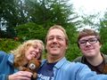
Expedition 5000 Team Photo
- 2011-10-09 45 -112 bins.jpg
The afterparty: Bargain shopping.


Achievements