Difference between revisions of "2011-10-02 55 13"
From Geohashing
imported>Llavids |
imported>FippeBot m (Location) |
||
| (One intermediate revision by one other user not shown) | |||
| Line 20: | Line 20: | ||
== Photos == | == Photos == | ||
<gallery perrow="3"> | <gallery perrow="3"> | ||
| − | Image:2011-10-02-55-13-01-Proof. | + | Image:2011-10-02-55-13-01-Proof.jpg|Blurry proof |
| − | Image:2011-10-02-55-13-02-View south. | + | Image:2011-10-02-55-13-02-View south.jpg|View south |
| − | Image:2011-10-02-55-13-03-Trace-and-target. | + | Image:2011-10-02-55-13-03-Trace-and-target.jpg|Trace going south, when going north we passed the coordinates |
</gallery> | </gallery> | ||
| Line 43: | Line 43: | ||
[[Category:Meetup on 2011-10-02]] | [[Category:Meetup on 2011-10-02]] | ||
[[Category:Sweden]] | [[Category:Sweden]] | ||
| + | {{location|SE|M}} | ||
Latest revision as of 01:06, 13 August 2019
| Sun 2 Oct 2011 in 55,13: 55.8560839, 13.6337055 geohashing.info google osm bing/os kml crox |
Location
On the road E22 near Hörby, Skåne, Sweden.
Participants
Llavids with family
Plans
We were going to Sölvesborg (more north on the E22) and passes the coordinates driving there.
Expedition
Forgot to document the drive going north, but upon returning we tried to get a photo with the mobiles and a trace from the GPS. All other cameras are currently broken so the mobiles must be used, giving bad pictures until a new camera is bought. Got a blurry picture from the GPS and a trace from the combined with the target coordinates showing we were only 8 meters off going south, thus passing over it going north.
Photos
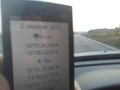
Blurry proof
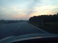
View south

Trace going south, when going north we passed the coordinates


Achievements
Llavids earned the Land geohash achievement
|
Llavids earned the Speed racer achievement
|