Difference between revisions of "2011-11-13 45 -122"
imported>Michael5000 m (→Michael5000) |
imported>FippeBot m (Location) |
||
| (13 intermediate revisions by 4 users not shown) | |||
| Line 1: | Line 1: | ||
| − | |||
| − | |||
| − | |||
| − | |||
| − | |||
| − | |||
| − | |||
| − | |||
| − | |||
{{meetup graticule | {{meetup graticule | ||
| lat=45 | | lat=45 | ||
| Line 16: | Line 7: | ||
__NOTOC__ | __NOTOC__ | ||
== Location == | == Location == | ||
| − | Near a | + | |
| + | Near a fence between driveways on SE 74th Avenue, near Powell Boulevard. | ||
== Participants == | == Participants == | ||
| Line 33: | Line 25: | ||
=== kydlt === | === kydlt === | ||
| − | Oh boy, a walk to hash. I am in-town watching the grandchildren and this is right in their SE hood | + | Oh boy, a walk-to hash. I am in-town watching the grandchildren and this is right in their SE hood. |
== Expedition == | == Expedition == | ||
| Line 45: | Line 37: | ||
===Kydlt=== | ===Kydlt=== | ||
| − | Kydlt and the grandchildren biked over. K. crashed once in the excitement. Spoke with the neighbor, the hashpoint seems to be right at the | + | Kydlt and the grandchildren biked over. K. crashed once in the excitement. Spoke with the neighbor, & he said that the folks that owned the house wouldn't mind if I took a photo right there, as the hashpoint seems to be right at the fence-line. At Thing1's insistence we also did a geocache on the way home. Everyone had fun. |
| + | |||
| + | === Jim === | ||
| + | |||
| + | Jim headed to the hashpoint and got there pretty easily, as there was an easy route there. | ||
| + | I asked at one house, but they said the fence didn't belong to them, that I should ask around | ||
| + | the corner. | ||
| + | |||
| + | The folks around the corner were happy to let me take a picture, so I wandered up to the fence | ||
| + | and did so. | ||
| − | + | On the way back to the car I noticed the markings on the sidewalk and took a picture. | |
| − | |||
== Photos == | == Photos == | ||
| Line 55: | Line 55: | ||
--> | --> | ||
<gallery perrow="5"> | <gallery perrow="5"> | ||
| + | Image:2011-11-13 45 -122 inside margin of error.jpg|Standing near the fence. | ||
| + | image:2100-11-13 45 -122 thing 1 & thing 2.jpg|My helpers, Thing1 & Thing2. | ||
| + | image:2011-11-13 45 -122 note.jpg|When the residents get home what will they think ? | ||
</gallery> | </gallery> | ||
| + | |||
| + | * Jim has some in the Camera | ||
== Achievements == | == Achievements == | ||
{{#vardefine:ribbonwidth|800px}} | {{#vardefine:ribbonwidth|800px}} | ||
| − | + | ||
| + | {{Land geohash | ||
| + | | latitude = 45 | ||
| + | | longitude = -122 | ||
| + | | date = 2011-11-13 | ||
| + | | name = [[User:Michael5000|Michael5000]] and Jim and [[User:kydlt|kydlt]] | ||
| + | }} | ||
| + | |||
| + | {{Ambassador geohash | ||
| + | | latitude = 45 | ||
| + | | longitude = -122 | ||
| + | | date = 2011-11-13 | ||
| + | | name = [[User:Jiml|Jim]] | ||
| + | }} | ||
| + | |||
| + | |||
{{A Tale of Two Hashes challenge | {{A Tale of Two Hashes challenge | ||
| Line 69: | Line 89: | ||
}} | }} | ||
| + | {{drag-along | ||
| + | | latitude = 45 | ||
| + | | longitude = -122 | ||
| + | | date = 2011-11-13 | ||
| + | | partner = Kelson & Portia | ||
| + | | name = [[User:kydlt|kydlt]] | ||
| − | + | }} | |
| − | + | {{Bicycle geohash | |
| − | + | | latitude = 45 | |
| − | + | | longitude = -122 | |
| − | + | | date = 2011-11-13 | |
| − | + | | name = Kydlt, Thing1 (6yr old) & Thing2 (4), all on bikes. | |
| − | + | | distance = not all that far | |
| + | }} | ||
[[Category:Expeditions]] | [[Category:Expeditions]] | ||
| − | |||
[[Category:Expeditions with photos]] | [[Category:Expeditions with photos]] | ||
| − | |||
| − | |||
| − | |||
| − | |||
[[Category:Coordinates reached]] | [[Category:Coordinates reached]] | ||
| − | + | {{location|US|OR|MU}} | |
| − | |||
| − | |||
| − | |||
| − | |||
| − | |||
| − | |||
| − | |||
| − | |||
Latest revision as of 01:31, 13 August 2019
| Sun 13 Nov 2011 in 45,-122: 45.4990202, -122.5873619 geohashing.info google osm bing/os kml crox |
Location
Near a fence between driveways on SE 74th Avenue, near Powell Boulevard.
Participants
Plans
Jim
This one looks promising. Google's a little unclear if it is just over the fence line, or near to a paved area. In any event, it appears easily accessible, assuming there are not permission problems.
- How about 2PM?? Jiml 14:15, 13 November 2011 (EST)
kydlt
Oh boy, a walk-to hash. I am in-town watching the grandchildren and this is right in their SE hood.
Expedition
Michael5000
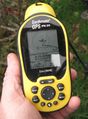
I woke up at dawn and ran to the hashpoint. It was still pretty much twilight on Sunday morning, no one around except dog-walkers, so I just stone cold ran quietly up the driveway, waved my GPS arm over the fence to sweep the hashpoint, and continued on through the quiet streets.
This was I believe only my second geohash completed completely on foot, and the first completed entirely by running. Distance covered: 5.89 miles.
Kydlt
Kydlt and the grandchildren biked over. K. crashed once in the excitement. Spoke with the neighbor, & he said that the folks that owned the house wouldn't mind if I took a photo right there, as the hashpoint seems to be right at the fence-line. At Thing1's insistence we also did a geocache on the way home. Everyone had fun.
Jim
Jim headed to the hashpoint and got there pretty easily, as there was an easy route there. I asked at one house, but they said the fence didn't belong to them, that I should ask around the corner.
The folks around the corner were happy to let me take a picture, so I wandered up to the fence and did so.
On the way back to the car I noticed the markings on the sidewalk and took a picture.
Photos
Standing near the fence.
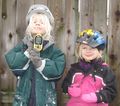
My helpers, Thing1 & Thing2.

When the residents get home what will they think ?


- Jim has some in the Camera
Achievements
Michael5000 and Jim and kydlt earned the Land geohash achievement
|
Jim earned the Ambassador achievement
|

kydlt earned the Drag-along achievement
|
Kydlt, Thing1 (6yr old) & Thing2 (4), all on bikes. earned the Bicycle geohash achievement
|