Difference between revisions of "2011-12-19 42 -88"
imported>RocketMac (→Tracklog) |
imported>RocketMac (→Achievements) |
||
| Line 53: | Line 53: | ||
{{#vardefine:ribbonwidth|800px}} | {{#vardefine:ribbonwidth|800px}} | ||
<!-- Add any achievement ribbons you earned below, or remove this section --> | <!-- Add any achievement ribbons you earned below, or remove this section --> | ||
| + | {{land geohash | ||
| + | | latitude = 42 | ||
| + | | longitude = -88 | ||
| + | | date = 2011-12-19 | ||
| + | | name = RocketMac | ||
| + | | image = | ||
| + | }} | ||
| + | {{Easy_geohash | ||
| + | | latitude = 42 | ||
| + | | longitude = -88 | ||
| + | | date = 2011-12-19 | ||
| + | | name = RocketMac | ||
| + | | image = | ||
| + | }} | ||
| + | <!-- | ||
| + | {{Blinded by Science | ||
| + | | latitude = 42 | ||
| + | | longitude = -88 | ||
| + | | date = 2011-12-19 | ||
| + | | reason = because the coordinate calculators were offline | ||
| + | | name = RocketMac | ||
| + | | image = | ||
| + | }} | ||
| + | --> | ||
| + | {{gratuitous ribbon | ||
| + | | color = #0000ff | ||
| + | | icon = ShowYourWork.png | ||
| + | | latitude = 42 | ||
| + | | longitude = -88 | ||
| + | | date = 2011-12-19 | ||
| + | | achievement = Teacher's Pet Award | ||
| + | | description = showing his work to calculate the | ||
| + | | name = RocketMac | ||
| + | | image = | ||
| + | }} | ||
<!-- =============== USEFUL CATEGORIES FOLLOW ================ | <!-- =============== USEFUL CATEGORIES FOLLOW ================ | ||
Delete the next line ONLY if you have chosen the appropriate categories below. If you are unsure, don't worry. People will read your report and help you with the classification. --> | Delete the next line ONLY if you have chosen the appropriate categories below. If you are unsure, don't worry. People will read your report and help you with the classification. --> | ||
| − | |||
<!-- Potential categories. Please include all the ones appropriate to your expedition --> | <!-- Potential categories. Please include all the ones appropriate to your expedition --> | ||
| Line 64: | Line 98: | ||
--> | --> | ||
| + | [[Category:Expeditions]] | ||
| + | [[Category:Expeditions with photos]] | ||
<!-- An actual expedition: | <!-- An actual expedition: | ||
| − | |||
-- and one or more of -- | -- and one or more of -- | ||
| − | |||
[[Category:Expeditions with videos]] | [[Category:Expeditions with videos]] | ||
[[Category:Expedition without GPS]] | [[Category:Expedition without GPS]] | ||
--> | --> | ||
| + | [[Category:Coordinates reached]] | ||
<!-- if you reached your coords: | <!-- if you reached your coords: | ||
| − | |||
--> | --> | ||
Revision as of 04:13, 20 December 2011
| Mon 19 Dec 2011 in 42,-88: 42.9655473, -88.1117935 geohashing.info google osm bing/os kml crox |
Location
The middle of Delphine Dr. in New Berlin, WI
Participants
Plans
When I checked my iPhone app this morning, the data seemed to come up slow but valid. When I checked peeron and one or two of the other calculators, there was no valid data for the day. I've been playing with these numbers manually recently, so what the heck! I grabbed the opening value from Yahoo! and played with my worksheet program to get the values. Since it's close to Christmas, I decided to check the list twice.
I spent some time during lunch on Google Maps to find a route from work to home that would pass through the coordinates without having to stop or cross my own GPS trail.
If this works out, I'll finally earn the Tron achievement for sure! ...and then I read that I have to return to the same spot! *sigh*
RocketMac 15:18, 19 December 2011 (EST)
Expedition
Tracklog
My log is available in GPX and KMZ formats
Photos

Stupid Grin
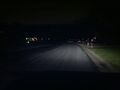
The hashpoint in the headlights

Showing my work
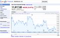
Numbers don't lie


Achievements
RocketMac earned the Land geohash achievement
|
RocketMac has visited an Easy Geohash
|
RocketMac earned the Teacher's Pet Award
|