Difference between revisions of "2012-01-09 -36 174"
imported>Greenslime m (Created page with "{{subst:Expedition |lat = -36 |lon = 174 |date = 2012-01-09 }}") |
imported>FippeBot m (Location) |
||
| (5 intermediate revisions by 3 users not shown) | |||
| Line 1: | Line 1: | ||
| − | |||
| − | |||
| − | |||
| − | |||
| − | |||
| − | |||
| − | |||
| − | |||
| − | |||
| − | |||
{{meetup graticule | {{meetup graticule | ||
| lat=-36 | | lat=-36 | ||
| Line 15: | Line 5: | ||
}} | }} | ||
| − | + | ||
__NOTOC__ | __NOTOC__ | ||
== Location == | == Location == | ||
| − | + | In the shrubbery of a driveway, Northcote, Auckland, New Zealand | |
== Participants == | == Participants == | ||
| − | + | * [[User:Greenslime|Greenslime]] | |
== Plans == | == Plans == | ||
| − | + | Drive there on way to elsewhere and try and be stealthy while meandering down someone's driveway. | |
| + | |||
| + | I have sussed a cache only 50 m away in a neighbouring park. I doubt I will be able to see either from each other, but I'll have a look. | ||
== Expedition == | == Expedition == | ||
| − | + | Very simple. I found the cache first behind some flax bushes at the entrance of a small strip of bush. The strip of bush was actually disguising a computer peripheral burial ground amongst waste of other types. Not clean. | |
| − | + | I then wandered down some randoms driveway, straight to the location identified in the satellite imagery, and nonchalantly stood and took photos of hash location, GPS and cache location. While the cache was only 50 m away - 2 fences, a backyard, and some large shrubs stood between the two locations. Good enough for an honourable mention. | |
| − | + | ||
| + | A link to cache information can be found [http://www.geocaching.com/seek/cache_details.aspx?wp=GC2GVQG here] | ||
== Photos == | == Photos == | ||
| − | |||
| − | |||
| − | |||
<gallery perrow="5"> | <gallery perrow="5"> | ||
| + | File:2012-01-09 -36 174 Hash Cache Location.JPG|Hash in blue, cache in green - only 50 m apart! | ||
| + | File:2012-01-09 -36 174 Hash Location.jpg|The location of the Hash Point. | ||
| + | File:2012-01-09 -36 174 GPS.jpg|Garmin. | ||
| + | File:2012-01-09 -36 174 Cache.JPG|The cache. | ||
| + | File:2012-01-09 -36 174 Cache from Hash.jpg|Cache location from the hash. | ||
</gallery> | </gallery> | ||
== Achievements == | == Achievements == | ||
{{#vardefine:ribbonwidth|800px}} | {{#vardefine:ribbonwidth|800px}} | ||
| − | |||
| − | + | * Land Geohash | |
| − | + | ||
| − | [[ | + | {{Hash collision |
| + | | latitude = -36 | ||
| + | | longitude = 174 | ||
| + | | date = 2012-01-09 | ||
| + | | name = [[User:Greenslime|Greenslime]] | ||
| + | | link = http://www.geocaching.com/seek/cache_details.aspx?wp=GC2GVQG | ||
| + | | id = GC2GVQG | ||
| + | | distance = 0.05 km | ||
| + | | honor = jolly good! | ||
| + | | image = 2012-01-09 -36 174 Cache.JPG | ||
| + | }} | ||
| + | |||
| + | |||
| + | {{Last man standing | ||
| + | | latitude = -36 | ||
| + | | longitude = 174 | ||
| + | | date = 2012-01-09 | ||
| + | | gender = chick | ||
| + | | name = [[User:Greenslime|Greenslime]] | ||
| + | | image = 2012-01-09 -36 174 Cache.JPG | ||
| + | }} | ||
| − | |||
| − | |||
| − | |||
| − | |||
| − | |||
[[Category:Expeditions]] | [[Category:Expeditions]] | ||
| − | + | [[Category:Expeditions with photos]] | |
| − | [[Category:Expeditions with photos]] | ||
| − | |||
| − | |||
| − | |||
| − | |||
| − | |||
[[Category:Coordinates reached]] | [[Category:Coordinates reached]] | ||
| − | + | {{location|NZ|AUK}} | |
| − | |||
| − | |||
| − | |||
| − | |||
| − | |||
| − | |||
| − | |||
| − | |||
| − | |||
Latest revision as of 02:00, 13 August 2019
| Mon 9 Jan 2012 in -36,174: -36.8050564, 174.7439033 geohashing.info google osm bing/os kml crox |
Location
In the shrubbery of a driveway, Northcote, Auckland, New Zealand
Participants
Plans
Drive there on way to elsewhere and try and be stealthy while meandering down someone's driveway.
I have sussed a cache only 50 m away in a neighbouring park. I doubt I will be able to see either from each other, but I'll have a look.
Expedition
Very simple. I found the cache first behind some flax bushes at the entrance of a small strip of bush. The strip of bush was actually disguising a computer peripheral burial ground amongst waste of other types. Not clean.
I then wandered down some randoms driveway, straight to the location identified in the satellite imagery, and nonchalantly stood and took photos of hash location, GPS and cache location. While the cache was only 50 m away - 2 fences, a backyard, and some large shrubs stood between the two locations. Good enough for an honourable mention.
A link to cache information can be found here
Photos
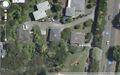
Hash in blue, cache in green - only 50 m apart!
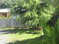
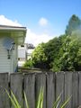
The location of the Hash Point.
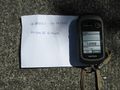
Garmin.
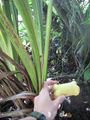
The cache.
Cache location from the hash.


Achievements
- Land Geohash
Greenslime earned the Hash collision honorable mention
|
Greenslime earned the Last chick standing achievement
|