Difference between revisions of "2012-01-10 45 -122"
imported>Kydlt (→Expedition) |
imported>Kydlt (→Photos) |
||
| Line 35: | Line 35: | ||
Image:2010-##-## ## ## Alpha.jpg | Witty Comment | Image:2010-##-## ## ## Alpha.jpg | Witty Comment | ||
--> | --> | ||
| + | <gallery perrow="6"> | ||
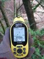
| + | Image:2012-01-10-45 -122 01 mid river.jpg|I had terrible satellite geometry. I was definitely still on the road, but the GPS said that I was in the river. | ||
| + | Image:2012-01-10-45 -122 12 track all over.jpg|As this track capture shows. For a long time it wouldn't even acquire. Only 1 sat was more than 30 degrees above the horizon. | ||
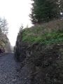
| + | Image:2012-01-10-45 -122 02 below cliffs.jpg|So first I went to the field below the cliffs. I thought the hash would be down here. | ||
| + | Image:2012-01-10-45 -122 03 but way up the hill.jpg|But when I was below the tracks & below the cliff, the GPS was showing me up the hill, above the road. | ||
| + | Image:2012-01-10-45 -122 04 the cliff.jpg|I got to the base of the cliff, the GPS was showing the hash more north, above the cliff. | ||
| + | Image:2012-01-10-45 -122 05 better numbers.jpg|The numbers were better, the GPS was claiming better accuracy, but..... | ||
| + | Image:2012-01-10-45 -122 06 Multnomah Falls across the river.jpg|Oh well. I had this view. I believe that to be Multnomah Falls, but I can't see the footpath bridge. | ||
| + | Image:2012-01-10-45 -122 08 Back up to RR tracks.jpg|So I climbed back up to the RR tracks. | ||
| + | Image:2012-01-10-45 -122 09 but still below road.jpg|But still below the road. | ||
| + | Image:2012-01-10-45 -122 10 then up this hill.jpg|And went up here to arrive to the top of the cliff. | ||
| + | Image:2012-01-10-45 -122 11 looking down from top.jpg|Now that I was here, the GPS said that I should be back down below. | ||
| + | Image:2012-01-10-45 -122 13 but still not right.jpg|So here is a close up of my track, layed over a USGS topo, using DeLorme Topo USA. The hash was, best that I could tell, on the cliff. But the cliff is between the tracks and the river. | ||
| + | </gallery> | ||
== Achievements == | == Achievements == | ||
Revision as of 03:40, 11 January 2012
| Tue 10 Jan 2012 in 45,-122: 45.5915681, -122.1394323 geohashing.info google osm bing/os kml crox |
Location
By the river.
Participants
Plans
kydlt
I might have to go to this one. I'm heading to Portland anyway.
Expedition
I just got back home (17:44) from an interesting hash trip. I will write it up later.
Photos
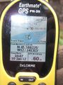
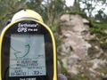
I had terrible satellite geometry. I was definitely still on the road, but the GPS said that I was in the river.
- 2012-01-10-45 -122 12 track all over.jpg
As this track capture shows. For a long time it wouldn't even acquire. Only 1 sat was more than 30 degrees above the horizon.
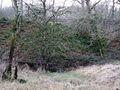
So first I went to the field below the cliffs. I thought the hash would be down here.
But when I was below the tracks & below the cliff, the GPS was showing me up the hill, above the road.
I got to the base of the cliff, the GPS was showing the hash more north, above the cliff.
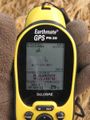
The numbers were better, the GPS was claiming better accuracy, but.....
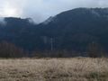
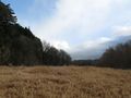
Oh well. I had this view. I believe that to be Multnomah Falls, but I can't see the footpath bridge.
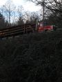
So I climbed back up to the RR tracks.
But still below the road.
And went up here to arrive to the top of the cliff.
Now that I was here, the GPS said that I should be back down below.
- 2012-01-10-45 -122 13 but still not right.jpg
So here is a close up of my track, layed over a USGS topo, using DeLorme Topo USA. The hash was, best that I could tell, on the cliff. But the cliff is between the tracks and the river.


