Difference between revisions of "2012-01-31 60 18"
imported>Cjk ([live picture] Nice place in the summer I guess) |
imported>FippeBot m (Location) |
||
| (17 intermediate revisions by 2 users not shown) | |||
| Line 1: | Line 1: | ||
| + | [[Image:{{{image|2012-01-31_60_18_14-53-52-237.jpg}}}|thumb|left]] | ||
| − | |||
| − | |||
| − | |||
| − | |||
| − | |||
| − | |||
| − | |||
| − | |||
| − | |||
{{meetup graticule | {{meetup graticule | ||
| lat=60 | | lat=60 | ||
| Line 19: | Line 11: | ||
== Location == | == Location == | ||
<!-- where you've surveyed the hash to be --> | <!-- where you've surveyed the hash to be --> | ||
| + | In the middle of the frozen lake Vällen. | ||
== Participants == | == Participants == | ||
<!-- who attended --> | <!-- who attended --> | ||
| + | [[User:Cjk|Carl-Johan]] | ||
== Plans == | == Plans == | ||
<!-- what were the original plans --> | <!-- what were the original plans --> | ||
| + | I was hoping that this lake would be frozen so I could get my first water geohash. | ||
== Expedition == | == Expedition == | ||
<!-- how it all turned out. your narrative goes here. --> | <!-- how it all turned out. your narrative goes here. --> | ||
| + | Being on the frozen lake this weekend near the geohash in Sala gave me an idea to try to get a water geohash without using a boat. I was looking for one and today there was a very promising point NE of me. So I jump in the car and take roads I've been on before towards Östhammar. The roads going to the hash were pretty empty and I found the right small road going into a Nature reserve and towards a swim shore, so it looked promising. Followed that road all the way to the end and a small cottage. Could see some snow scooter tracks going past. | ||
| + | The actual lake was frozen and covered with snow and the ice seemed very thick and solid. No sounds, no cracking or so. So I walked onto it. I saw lots of animal tracks, some hares and maybe a fox. And then someone had skied over the lake, a good sign. And as I came around a peninsula I could see some 4-wheeler tracks. He had gotten stuck twice in some slush and turned around so some water had seeped up from some cracks in the ice. I continued walking straight onto the middle of the lake and after a total of 500m from the car I found the hash point. | ||
| − | *I'm standing on a frozen lake -- [[User:Cjk| | + | [[Image:2012-01-31_60_18_14-54-47-903.jpg]] |
| − | + | ||
| − | + | *I'm standing on a frozen lake -- [[User:Cjk|Carl-Johan]] [http://www.openstreetmap.org/?lat=60.03773129&lon=18.33963758&zoom=16&layers=B000FTF @60.0377,18.3396] 08:46, 31 January 2012 (EST) | |
| + | |||
| + | So I mark the spot with orange in the snow as usual and snap some pics. Stand there and enjoy the view for a bit before heading back to the car. | ||
| + | |||
| + | Had to take a slight detour to Danderyd so I wouldn't get stuck in traffic on the E4 which was standing still as usual my GPS told me. Nose, cheeks and ears are a bit hot now after being out in the cold, but it wasn't actually frozen when on the lake I think, just cold. | ||
| + | |||
| + | It was on ice though so my first water geohash and walking on water geohash. | ||
| + | |||
| + | Remember your basic ice [https://www.youtube.com/watch?v=ysnKtuUTt8k self rescue]. | ||
== Photos == | == Photos == | ||
| Line 41: | Line 46: | ||
Image:2012-01-31_60_18_12-49-28-421.jpg | Lets try a water hash [http://www.openstreetmap.org/?lat=59.32350000&lon=17.99460000&zoom=16&layers=B000FTF @59.3235,17.9946] | Image:2012-01-31_60_18_12-49-28-421.jpg | Lets try a water hash [http://www.openstreetmap.org/?lat=59.32350000&lon=17.99460000&zoom=16&layers=B000FTF @59.3235,17.9946] | ||
| + | |||
| + | Image:2012-01-31_60_18_18-59-57-543.jpg | There is lake Vällen | ||
| + | |||
| + | Image:2012-01-31_60_18_19-00-21-765.jpg | Walking out | ||
| + | |||
| + | Image:2012-01-31_60_18_19-01-04-441.jpg | Cottage I came from | ||
| + | |||
| + | Image:2012-01-31_60_18_19-04-15-835.jpg | Nice place in the summer I guess | ||
| + | |||
| + | Image:2012-01-31_60_18_19-02-02-594.jpg | Officially on the lake | ||
| + | |||
| + | Image:2012-01-31_60_18_19-04-38-304.jpg | The lake | ||
| + | |||
| + | Image:2012-01-31_60_18_19-05-29-865.jpg | More cottages | ||
| + | |||
| + | Image:2012-01-31_60_18_19-06-12-357.jpg | Solid ice | ||
| + | |||
| + | Image:2012-01-31_60_18_19-07-18-465.jpg | Someone got stuck in some slush with a 4-wheeler | ||
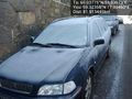
Image:2012-01-31_60_18_14-53-52-237.jpg | The Breeders [http://www.openstreetmap.org/?lat=60.03770000&lon=18.33970000&zoom=16&layers=B000FTF @60.0377,18.3397] | Image:2012-01-31_60_18_14-53-52-237.jpg | The Breeders [http://www.openstreetmap.org/?lat=60.03770000&lon=18.33970000&zoom=16&layers=B000FTF @60.0377,18.3397] | ||
| Line 52: | Line 75: | ||
Image:2012-01-31_60_18_14-57-10-395.jpg | Ice ice baby [http://www.openstreetmap.org/?lat=60.03770000&lon=18.33960000&zoom=16&layers=B000FTF @60.0377,18.3396] | Image:2012-01-31_60_18_14-57-10-395.jpg | Ice ice baby [http://www.openstreetmap.org/?lat=60.03770000&lon=18.33960000&zoom=16&layers=B000FTF @60.0377,18.3396] | ||
| − | Image:2012-01- | + | Image:2012-01-31_60_18_19-08-09-323.jpg | Other shore |
| + | |||
| + | Image:2012-01-31_60_18_19-08-39-118.jpg | Back where I came from | ||
| − | Image:2012-01-31_60_18_19- | + | Image:2012-01-31_60_18_19-09-17-213.jpg | Looking south |
| − | Image:2012-01-31_60_18_19- | + | Image:2012-01-31_60_18_19-10-08-416.jpg | Water seeped up from a crack and froze the slush |
| − | Image:2012-01-31_60_18_19- | + | Image:2012-01-31_60_18_19-11-19-854.jpg | Sun setting |
</gallery> | </gallery> | ||
| Line 64: | Line 89: | ||
{{#vardefine:ribbonwidth|800px}} | {{#vardefine:ribbonwidth|800px}} | ||
<!-- Add any achievement ribbons you earned below, or remove this section --> | <!-- Add any achievement ribbons you earned below, or remove this section --> | ||
| + | {{water geohash | latitude = 60 | longitude = 18 | date = 2012-01-31 | name = [[User:Cjk|Carl-Johan]] }} | ||
| + | {{walking on water geohash | latitude = 60 | longitude = 18 | date = 2012-01-31 | name = [[User:Cjk|Carl-Johan]] | image = 2012-01-31_60_18_14-57-10-395.jpg }} | ||
| + | [[Category:Expeditions]] | ||
| − | |||
| − | |||
| − | |||
| − | |||
| − | |||
| − | |||
| − | |||
| − | |||
| − | |||
| − | |||
| − | |||
| − | |||
[[Category:Expeditions with photos]] | [[Category:Expeditions with photos]] | ||
| − | |||
| − | |||
| − | |||
| − | |||
[[Category:Coordinates reached]] | [[Category:Coordinates reached]] | ||
| − | + | {{location|SE|C}} | |
| − | |||
| − | |||
| − | |||
| − | |||
| − | |||
| − | |||
| − | |||
| − | |||
| − | |||
Latest revision as of 02:15, 13 August 2019

| Tue 31 Jan 2012 in 60,18: 60.0377527, 18.3397324 geohashing.info google osm bing/os kml crox |
Location
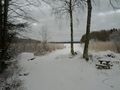
In the middle of the frozen lake Vällen.
Participants
Plans
I was hoping that this lake would be frozen so I could get my first water geohash.
Expedition
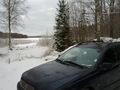
Being on the frozen lake this weekend near the geohash in Sala gave me an idea to try to get a water geohash without using a boat. I was looking for one and today there was a very promising point NE of me. So I jump in the car and take roads I've been on before towards Östhammar. The roads going to the hash were pretty empty and I found the right small road going into a Nature reserve and towards a swim shore, so it looked promising. Followed that road all the way to the end and a small cottage. Could see some snow scooter tracks going past.
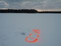
The actual lake was frozen and covered with snow and the ice seemed very thick and solid. No sounds, no cracking or so. So I walked onto it. I saw lots of animal tracks, some hares and maybe a fox. And then someone had skied over the lake, a good sign. And as I came around a peninsula I could see some 4-wheeler tracks. He had gotten stuck twice in some slush and turned around so some water had seeped up from some cracks in the ice. I continued walking straight onto the middle of the lake and after a total of 500m from the car I found the hash point.

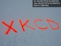
- I'm standing on a frozen lake -- Carl-Johan @60.0377,18.3396 08:46, 31 January 2012 (EST)
So I mark the spot with orange in the snow as usual and snap some pics. Stand there and enjoy the view for a bit before heading back to the car.
Had to take a slight detour to Danderyd so I wouldn't get stuck in traffic on the E4 which was standing still as usual my GPS told me. Nose, cheeks and ears are a bit hot now after being out in the cold, but it wasn't actually frozen when on the lake I think, just cold.
It was on ice though so my first water geohash and walking on water geohash.
Remember your basic ice self rescue.
Photos
Lets try a water hash @59.3235,17.9946
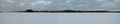
There is lake Vällen
Walking out
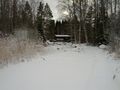
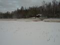
Cottage I came from
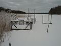
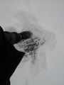
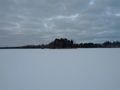
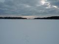
Nice place in the summer I guess
Officially on the lake
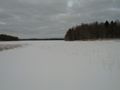
The lake
More cottages
Solid ice
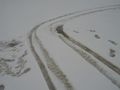
Someone got stuck in some slush with a 4-wheeler

The Breeders @60.0377,18.3397
Marker @60.0377,18.3397
Panorama 1 @60.0377,18.3398
Panorama 2 @60.0378,18.3397
Ice ice baby @60.0377,18.3396
Other shore
Back where I came from
Looking south

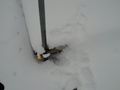
Water seeped up from a crack and froze the slush

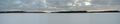
Sun setting


Achievements
Carl-Johan earned the Water geohash achievement
|
Carl-Johan earned the Walking on water geohash achievement
|