Difference between revisions of "2012-02-13 51 -2"
From Geohashing
imported>Sourcerer ([live] Arrived) |
imported>Sourcerer |
||
| Line 1: | Line 1: | ||
| − | |||
| − | |||
| − | |||
| − | |||
| − | |||
| − | |||
| − | |||
| − | |||
| − | |||
| − | |||
{{meetup graticule | {{meetup graticule | ||
| − | | lat=51 | + | | lat=51 |
| − | | lon=-2 | + | | lon=-2 |
| − | | date=2012-02-13 | + | | date=2012-02-13 |
| + | | graticule_name=Bristol | ||
| + | | graticule_link=Bristol, United Kingdom | ||
}} | }} | ||
| − | |||
| − | |||
== Location == | == Location == | ||
| − | < | + | |
| + | 1.3 km from Bagwyllydiart and on a bearing of 66<sup>o</sup>. Although in England, this is a very Welsh sounding location. | ||
== Participants == | == Participants == | ||
| − | |||
| − | + | [[User:Sourcerer|Sourcerer]] | |
| − | |||
== Expedition == | == Expedition == | ||
| − | |||
| − | |||
*Arrived -- [[User:Sourcerer|Sourcerer]] [http://www.openstreetmap.org/?lat=51.94280683994293&lon=-2.7956396341323853&zoom=16&layers=B000FTF @51.9428,-2.7956] 15:31, 13 February 2012 (GMT) | *Arrived -- [[User:Sourcerer|Sourcerer]] [http://www.openstreetmap.org/?lat=51.94280683994293&lon=-2.7956396341323853&zoom=16&layers=B000FTF @51.9428,-2.7956] 15:31, 13 February 2012 (GMT) | ||
| − | |||
| − | |||
| − | + | This doublehash came about after another weekend of beer and curry with good friends. I altered my route home to take in two new graticules and a new country too. | |
| − | |||
| − | |||
| − | |||
| − | |||
| − | |||
| − | + | I found a parking place and set out on foot. The public footpath I was seeking was gated and not signposted and there was a warning about loose dogs. Once again I had to find an alternative way. Further up the hill there was easy access to the sheep field containing the hashpoint. A couple of minutes later I'd arrived and taken the photo. | |
| − | |||
| − | |||
| + | == Photo Gallery == | ||
| − | < | + | <gallery perrow="3"> |
| − | + | Image:2012-02-13_51_-2_Sourcerer.jpg|Google Earth - Car Journey | |
| − | + | Image:2012-02-13 51 -2 Sourcerer-1.jpg|Google Earth - The Walk | |
| + | Image:2012-02-13 51 -2 Sourcerer-2.jpg|View of the hashpoint | ||
| + | </gallery> | ||
| − | + | == Other geohashing expeditions on the same day == | |
| − | |||
| − | |||
| − | |||
| − | + | {{expedition summaries|2012-02-13}} | |
| + | |||
| + | [[Category:Meetup on 2012-02-13]] | ||
| + | [[Category:Meetup in 51 -2]] | ||
[[Category:Expeditions]] | [[Category:Expeditions]] | ||
| − | |||
[[Category:Expeditions with photos]] | [[Category:Expeditions with photos]] | ||
| − | |||
| − | |||
| − | |||
| − | |||
| − | |||
[[Category:Coordinates reached]] | [[Category:Coordinates reached]] | ||
| − | |||
| − | |||
| − | |||
| − | |||
| − | |||
| − | |||
| − | |||
| − | |||
| − | |||
| − | |||
Revision as of 22:34, 13 February 2012
| Mon 13 Feb 2012 in Bristol: 51.9428011, -2.7956477 geohashing.info google osm bing/os kml crox |
Contents
Location
1.3 km from Bagwyllydiart and on a bearing of 66o. Although in England, this is a very Welsh sounding location.
Participants
Expedition
- Arrived -- Sourcerer @51.9428,-2.7956 15:31, 13 February 2012 (GMT)
This doublehash came about after another weekend of beer and curry with good friends. I altered my route home to take in two new graticules and a new country too.
I found a parking place and set out on foot. The public footpath I was seeking was gated and not signposted and there was a warning about loose dogs. Once again I had to find an alternative way. Further up the hill there was easy access to the sheep field containing the hashpoint. A couple of minutes later I'd arrived and taken the photo.
Photo Gallery
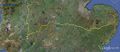
Google Earth - Car Journey
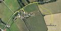
Google Earth - The Walk
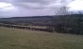
View of the hashpoint


Other geohashing expeditions on the same day
Expeditions and Plans
| 2012-02-13 | ||
|---|---|---|
| Schweinfurt, Germany | Rincewind, Mampfred | On a field near Gotha - or Tüttleben to be precise. |
| Bristol, United Kingdom | Sourcerer | 2) 1.3 km from Bagwyllydiart and on a bearing of 66o. Although in England, ... |
| Shrewsbury, United Kingdom | Sourcerer | 1) Just over the border in Wales 1.4 km east of Hanmer Mere. 2012-02-13 52 -2 :: 2012-02-13 51 -2 |