Difference between revisions of "2012-03-01 47 11"
imported>The T-Man (Set up page) |
imported>The T-Man (My hash!) |
||
| Line 1: | Line 1: | ||
| − | |||
| − | |||
| − | |||
| − | |||
| − | |||
| − | |||
| − | |||
| − | |||
| − | |||
{{meetup graticule | {{meetup graticule | ||
| lat=47 | | lat=47 | ||
| Line 14: | Line 5: | ||
}} | }} | ||
| − | |||
__NOTOC__ | __NOTOC__ | ||
== Location == | == Location == | ||
| − | In a small forest near Gmund, Tegernsee, Bavaria, Germany. | + | In a small forest near Gmund, Tegernsee, Bavaria, Germany. Well, they always look small in the satellite picture, don't they? And I really should start expecting height differences when I go there. |
== Participants == | == Participants == | ||
| Line 23: | Line 13: | ||
== Plans == | == Plans == | ||
| − | + | The plan was to go there in the early afternoon after I visited my mom in Bad Wiessee. Turned out the bus connection between Gmund and Bad Wiessee ran on a very comfortable course for reaching the Geohash. | |
== Expedition == | == Expedition == | ||
| − | + | As planned, I took the BOB (Bayerische Oberlandbahn) at around 8 a.m. from Munich Central to Gmund, a very picturesque village on the shoe of the Tegernssee lake, which is one of the several beautiful lakes between Munich and the Alps. From there on, I took the bus to Bad Wiessee, another village at the lakeshore, well known for its healthy spas and one of the few state-run casinos in Bavaria. Even though snow was still all around with temperatures at around 16°C, the bright sunshine allowed well for wearing a T-shirt that day. I sat at the lakeshore reading my newspaper for about two hours and fortunately was able to help bringing some dogs back to the shore who had broken through the now very thin ice layer that still covered most of the Tegernsee. | |
| − | + | After I had visited my mom, I took the bus back to Gmund and kept checking my GPS for when the distance to the hashpoint would be the least. As it turned out, the bus station lay only some 500 metres away from the spot. | |
| − | == | + | === The Hashpoint === |
| − | + | My way to the hash led my along a small paved road for a short distance, then across a meadow which - surprisingly - still had about 20 cm of snow on it. Seems like my choice of shoes was all to optimistic after all. The last 300 meters yielded a rather steep climb through the forest. My plan to catch the next bus only half an hour later added some extra adrenaline. The point itself was rather unspectacular and lay - well, in the middle of the forest. My GPS chased me back and forth for a few minutes unil I managed to nail down the spot. After taking some pictures, descended the slope half-tumbling and half climbing in a more controlled manner and just managed to catch the bus as well as my train back to Munich from Gmund. | |
== Photos == | == Photos == | ||
| − | |||
| − | |||
| − | |||
<gallery perrow="5"> | <gallery perrow="5"> | ||
| + | Image: 2012-03-01-TMan-01.jpg | This was one of the many beautiful impressions from still wintery Bad Wiessee | ||
| + | Image: 2012-03-01-TMan-02.jpg | This here as well | ||
| + | Image: 2012-03-01-TMan-03.jpg | This is where Luke and Leia, the two dogs, broke into the lake | ||
| + | Image: 2012-03-01-TMan-04.jpg | That's where I left the road. Why do they have to put up barbed wire everywhere? | ||
| + | Image: 2012-03-01-TMan-05.jpg | This is when I started to reflect about my choice of footgear | ||
| + | Image: 2012-03-01-TMan-06.jpg | Me (obviously a bit out of breath) marching through the snow | ||
| + | Image: 2012-03-01-TMan-07.jpg | The view, however, was breathtaking, too! | ||
| + | Image: 2012-03-01-TMan-08.jpg | Now that was one demotivating perspective! | ||
| + | Image: 2012-03-01-TMan-09.jpg | I believe this was the first time I got my GPS to show a remaining distance of 0.00 | ||
| + | Image: 2012-03-01-TMan-10.jpg | And here's the coordinates as well | ||
| + | Image: 2012-03-01-TMan-11.jpg | Looks like one typical hashpoint | ||
| + | Image: 2012-03-01-TMan-12.jpg | And the typical selfshot of mine | ||
| + | Image: 2012-03-01-TMan-13.jpg | Sadly, you don't get to see such beautiful train stations very often any more | ||
| + | Image: 2012-03-01-TMan-14.jpg | Gmund's, ahem, "City centre" with my train passing | ||
| + | Image: 2012-03-01-TMan-15.jpg | And here arrives my train. It was later coupled with three more diesel engines of the kind. | ||
</gallery> | </gallery> | ||
| − | |||
| − | |||
| − | |||
| − | |||
| − | |||
| − | |||
| − | |||
[[Category:Expeditions]] | [[Category:Expeditions]] | ||
| − | |||
[[Category:Expeditions with photos]] | [[Category:Expeditions with photos]] | ||
| − | |||
| − | |||
| − | |||
| − | |||
| − | |||
[[Category:Coordinates reached]] | [[Category:Coordinates reached]] | ||
| − | |||
| − | |||
| − | |||
| − | |||
| − | |||
| − | |||
| − | |||
| − | |||
| − | |||
| − | |||
Revision as of 10:05, 2 March 2012
| Thu 1 Mar 2012 in 47,11: 47.7474107, 11.7168382 geohashing.info google osm bing/os kml crox |
Location
In a small forest near Gmund, Tegernsee, Bavaria, Germany. Well, they always look small in the satellite picture, don't they? And I really should start expecting height differences when I go there.
Participants
Plans
The plan was to go there in the early afternoon after I visited my mom in Bad Wiessee. Turned out the bus connection between Gmund and Bad Wiessee ran on a very comfortable course for reaching the Geohash.
Expedition
As planned, I took the BOB (Bayerische Oberlandbahn) at around 8 a.m. from Munich Central to Gmund, a very picturesque village on the shoe of the Tegernssee lake, which is one of the several beautiful lakes between Munich and the Alps. From there on, I took the bus to Bad Wiessee, another village at the lakeshore, well known for its healthy spas and one of the few state-run casinos in Bavaria. Even though snow was still all around with temperatures at around 16°C, the bright sunshine allowed well for wearing a T-shirt that day. I sat at the lakeshore reading my newspaper for about two hours and fortunately was able to help bringing some dogs back to the shore who had broken through the now very thin ice layer that still covered most of the Tegernsee. After I had visited my mom, I took the bus back to Gmund and kept checking my GPS for when the distance to the hashpoint would be the least. As it turned out, the bus station lay only some 500 metres away from the spot.
The Hashpoint
My way to the hash led my along a small paved road for a short distance, then across a meadow which - surprisingly - still had about 20 cm of snow on it. Seems like my choice of shoes was all to optimistic after all. The last 300 meters yielded a rather steep climb through the forest. My plan to catch the next bus only half an hour later added some extra adrenaline. The point itself was rather unspectacular and lay - well, in the middle of the forest. My GPS chased me back and forth for a few minutes unil I managed to nail down the spot. After taking some pictures, descended the slope half-tumbling and half climbing in a more controlled manner and just managed to catch the bus as well as my train back to Munich from Gmund.
Photos
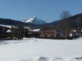
This was one of the many beautiful impressions from still wintery Bad Wiessee
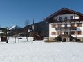
This here as well
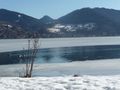
This is where Luke and Leia, the two dogs, broke into the lake
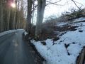
That's where I left the road. Why do they have to put up barbed wire everywhere?
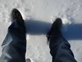
This is when I started to reflect about my choice of footgear

Me (obviously a bit out of breath) marching through the snow
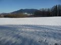
The view, however, was breathtaking, too!
Now that was one demotivating perspective!
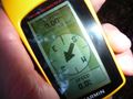
I believe this was the first time I got my GPS to show a remaining distance of 0.00
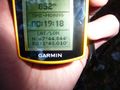
And here's the coordinates as well
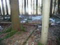
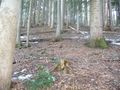
Looks like one typical hashpoint
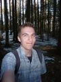
And the typical selfshot of mine
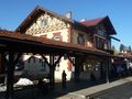
Sadly, you don't get to see such beautiful train stations very often any more
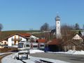
Gmund's, ahem, "City centre" with my train passing
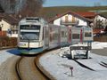
And here arrives my train. It was later coupled with three more diesel engines of the kind.


