Difference between revisions of "2012-03-01 38 -90"
From Geohashing
imported>Niffrig |
imported>FippeBot m (Location) |
||
| (One intermediate revision by one other user not shown) | |||
| Line 31: | Line 31: | ||
Image:Church parking lot.jpg|Where we parked | Image:Church parking lot.jpg|Where we parked | ||
</gallery> | </gallery> | ||
| + | |||
| + | [[Category:Expeditions]] | ||
| + | [[Category:Expeditions with photos]] | ||
| + | [[Category:Coordinates reached]] | ||
| + | {{location|US|MO|SA}} | ||
Latest revision as of 02:38, 13 August 2019
| Thu 1 Mar 2012 in St. Louis, Missouri: 38.7915168, -90.6870629 geohashing.info google osm bing/os kml crox |
Location
These coordinates were located in the St. Louis, Missouri graticule on 2012-03-01, in the city of O'Fallon near Mexico Road.
38.791516°, -90.687063°
Expedition Report
The spot was on the edge of a person's yard. We ended up parking up the road at a church and walking along the busy street. We had to brave some brush along a small branch. Someone, presumably the home owner, was mowing the lawn with a riding mower that had a heavy roller behind it. He looked perplexed but did not confront us. The group then went and ate chicken sandwiches. This wasn't a difficult location for us as it is only about 3 miles from work.
People
11:30 AM CST
Images
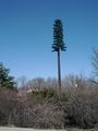
Tower disguise!

As is tradition

What a strange place for a stuffed animal
Where we parked


