Difference between revisions of "2012-03-21 48 11"
imported>The T-Man (→Expedition: Wrote report) |
imported>FippeBot m (Location) |
||
| (9 intermediate revisions by 3 users not shown) | |||
| Line 10: | Line 10: | ||
== Participants == | == Participants == | ||
| − | [[User:The_T-Man|The_T-Man]], [[User:DerFlob|DerFlob]] | + | [[User:The_T-Man|The_T-Man]], [[User:DerFlob|DerFlob]], [[User:Robert|Robert]] |
== Plans == | == Plans == | ||
| Line 20: | Line 20: | ||
=== [[User:DerFlob|DerFlob]] === | === [[User:DerFlob|DerFlob]] === | ||
| + | |||
| + | I took the subway at 10:30 a.m. heading to München's central station where I changed to the suburban train S7. After about 45 minutes I arrived at the station Pullach, from where I started walking towards the hashpoint. I originally planned about 20-30 minutes for the walk. Due to some confusion with a gate, of which I thought it was there to keep me out, but as it turned out was there to keep animals in, it took me about 45 minutes to find the approximate spot of the hash. Since I don't own a GPS system I tried guessing the position as best I could with a Google Earth map I printed out. Unfortunately it didn't work out that well, because after meeting [[User:The_T-Man|The_T-Man]] he directed me to the actual spot, which was about another 100 meters further into the forest. | ||
| + | |||
| + | After taking some pictures, we headed back towards the train station, where our paths parted, me taking the same way back as I came. | ||
=== [[User:The_T-Man|The_T-Man]] === | === [[User:The_T-Man|The_T-Man]] === | ||
| Line 27: | Line 31: | ||
On my way back, I stopped in Pullach's city center and bought some water. On my way back, I also joined the river earlier and followed it a bit longer into the city, making the journey back a bit more pleasant to the eye. My overall distance traveled was about 41 kilometers and about as much as I can go by bike without getting totally exhausted from it. | On my way back, I stopped in Pullach's city center and bought some water. On my way back, I also joined the river earlier and followed it a bit longer into the city, making the journey back a bit more pleasant to the eye. My overall distance traveled was about 41 kilometers and about as much as I can go by bike without getting totally exhausted from it. | ||
| − | === At the hashpoint === | + | === At the hashpoint (DerFlob & The_T-Man) === |
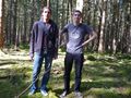
[[User:The_T-Man|The_T-Man]] arrived about half an hour before [[User:DerFlob|DerFlob]]. He used the time to recover from the trip and mark the hashpoint with a couple of sticks that read ''xkcd''. Actually meeting DerFlob was hindered by the fact that cell phone reception was rather intermittent and DerFlob had only Google-Earth-printouts as a means of navigation. However, the expedition members found themselves and the spot (which was good since The_T-Man left some of his belongings there), set up a woodland camera stand to take the obligatory picture and made their way back to the Pullach railroad station by foot. | [[User:The_T-Man|The_T-Man]] arrived about half an hour before [[User:DerFlob|DerFlob]]. He used the time to recover from the trip and mark the hashpoint with a couple of sticks that read ''xkcd''. Actually meeting DerFlob was hindered by the fact that cell phone reception was rather intermittent and DerFlob had only Google-Earth-printouts as a means of navigation. However, the expedition members found themselves and the spot (which was good since The_T-Man left some of his belongings there), set up a woodland camera stand to take the obligatory picture and made their way back to the Pullach railroad station by foot. | ||
| + | |||
| + | |||
| + | ===[[User:Robert|Robert]]=== | ||
| + | |||
| + | Not knowing about any other plans, i decided to try this one starting around 1400 at my place. After about 2 hours and around 50km (including one pretty nice 25% climb) i did get fairly close, but had to carry my bike the last maybe 50 meters to the hashpoint, which is in the middle of the forest. Not much around there, so i left for the way back home before it gets too cold and dark. | ||
| + | GPS accuracy was pretty bad, as anyone would expect at a place like that. | ||
== Photos == | == Photos == | ||
| − | + | ||
| − | + | === [[User:DerFlob|DerFlob]] === | |
| − | |||
<gallery perrow="5"> | <gallery perrow="5"> | ||
| + | Image:2012-03-21 48 11 Flob 01.JPG | Map of Forstenrieder Park | ||
| + | Image:2012-03-21 48 11 Flob 02.jpg | Information and Warnings | ||
| + | Image:2012-03-21 48 11 Flob 03.jpg | The gate that slowed me | ||
| + | Image:2012-03-21 48 11 Flob 04.jpg | A fallen over tree near the gate | ||
| + | Image:2012-03-21 48 11 Flob 05.jpg | Our improvised contraption to take the obligatory picture of us | ||
</gallery> | </gallery> | ||
| − | == | + | === [[User:The_T-Man|The_T-Man]] === |
| − | + | <gallery perrow="5"> | |
| − | + | Image:2012-03-21-TMan-01.jpg | The forest at the approximate point | |
| + | Image:2012-03-21-TMan-02.jpg | Remaining distance | ||
| + | Image:2012-03-21-TMan-03.jpg | Coordinates displayed at the hashpoint | ||
| + | Image:2012-03-21-TMan-04.jpg | Us being photographed by the camera on the 100% organic makeshift stand | ||
| + | Image:2012-03-21-TMan-05.jpg | Marker I prepared while waiting for DerFlob | ||
| + | Image:2012-03-21-TMan-06.jpg | I find this hedge to a) cut off space of the garden and b) be just way too smug | ||
| + | Image:2012-03-21-TMan-07.jpg | A castle, refurbished to be a youth hostel | ||
| + | Image:2012-03-21-TMan-08.jpg | The Großhesselohe railroad bridge across the Isar river on my way back | ||
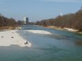
| + | Image:2012-03-21-TMan-09.jpg | The view N (you can already see the combustion plant's chimney) | ||
| + | Image:2012-03-21-TMan-10.jpg | Same view, a bit closer to the city | ||
| + | Image:2012-03-21-TMan-11.jpg | The view back south towards Pullach and the hashpoint | ||
| + | Image:2012-03-21-TMan-12.jpg | No, they're not indigenous, that's just the zoo at Thalkirchen | ||
| + | Image:2012-03-21-TMan-13.jpg | The combustion plant München Süd | ||
| + | Image:2012-03-21-TMan-14.jpg | One of München's notable churches in Giesing | ||
| + | </gallery> | ||
| + | |||
| + | === [[User:Robert|Robert]] === | ||
| + | <gallery perrow="5"> | ||
| + | Image:HPIM2485.JPG | GPS | ||
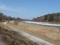
| + | Image:HPIM2491.JPG | Somewhere... | ||
| + | </gallery> | ||
| − | |||
| − | |||
[[Category:Expeditions]] | [[Category:Expeditions]] | ||
| − | + | [[Category:Expeditions with photos]] | |
| − | [[Category:Expeditions with photos]] | ||
| − | |||
| − | |||
| − | |||
| − | |||
| − | |||
[[Category:Coordinates reached]] | [[Category:Coordinates reached]] | ||
| − | + | {{location|DE|BY|M}} | |
| − | |||
| − | |||
| − | |||
| − | |||
| − | |||
| − | |||
| − | |||
| − | |||
| − | |||
Latest revision as of 03:05, 13 August 2019
| Wed 21 Mar 2012 in 48,11: 48.0625513, 11.4909986 geohashing.info google osm bing/os kml crox |
Location
In Forstenrieder Park, just S of München.
Participants
Plans
Plan for The_T-Man is to cycle there from Rosenheimer Platz to about Thalkirchen along the Isar river. Maybe I'll get myself up early enough to start this at 10 a.m. or so.
- Since I caught a minor cold during the last trip, I won't join you with my bicycle. Instead I'll be taking the train to Pullach and walk the remaining distance. How about we meet there at something in between 11:30 and 12:00? -DerFlob 14:43, 20 March 2012 (EDT)
- Very well, I'll arrange for me to arrive there at about that time. I'm not so sure about my timing accuracy, so you might bring a bit of patience with you ;) -The T-Man 04:12, 21 March 2012 (EDT)
Expedition
DerFlob
I took the subway at 10:30 a.m. heading to München's central station where I changed to the suburban train S7. After about 45 minutes I arrived at the station Pullach, from where I started walking towards the hashpoint. I originally planned about 20-30 minutes for the walk. Due to some confusion with a gate, of which I thought it was there to keep me out, but as it turned out was there to keep animals in, it took me about 45 minutes to find the approximate spot of the hash. Since I don't own a GPS system I tried guessing the position as best I could with a Google Earth map I printed out. Unfortunately it didn't work out that well, because after meeting The_T-Man he directed me to the actual spot, which was about another 100 meters further into the forest.
After taking some pictures, we headed back towards the train station, where our paths parted, me taking the same way back as I came.
The_T-Man
Started at about 10 a.m. and cycled towards the Isar river, but wasn't quite sure which road to take there. In the end, I decided to drive through Giesing, a nice city quarter with a bit of a traditional and down-to-earth atmosphere. Continued along the Mittlerer Ring, München's main circular road, which was not that pleasant. At the Heizkraftwerk Süd, one of München's major combustion plants, I took the bicycle trail along the river until the zoo at Thalkirchen. From there, my route led me to an ascent of about 50 meters on a steep and narrow street with my heart rate maxing out at about 192. That's what you get for staying at home all winter. I continued along a rather unpleasant arterial road that left München towards the south, past Solln's woodland cemetery from 2010-09-06 48 11. Shortly after that, I took a turn and headed past a horse ranch into the Forstenrieder Park, a forested recreational area and location of our hashpoint. Unfortunately, I left the trail once again much too early and had to walk the remaining 1200 meters to the point through the forest with my bike.
On my way back, I stopped in Pullach's city center and bought some water. On my way back, I also joined the river earlier and followed it a bit longer into the city, making the journey back a bit more pleasant to the eye. My overall distance traveled was about 41 kilometers and about as much as I can go by bike without getting totally exhausted from it.
At the hashpoint (DerFlob & The_T-Man)
The_T-Man arrived about half an hour before DerFlob. He used the time to recover from the trip and mark the hashpoint with a couple of sticks that read xkcd. Actually meeting DerFlob was hindered by the fact that cell phone reception was rather intermittent and DerFlob had only Google-Earth-printouts as a means of navigation. However, the expedition members found themselves and the spot (which was good since The_T-Man left some of his belongings there), set up a woodland camera stand to take the obligatory picture and made their way back to the Pullach railroad station by foot.
Robert
Not knowing about any other plans, i decided to try this one starting around 1400 at my place. After about 2 hours and around 50km (including one pretty nice 25% climb) i did get fairly close, but had to carry my bike the last maybe 50 meters to the hashpoint, which is in the middle of the forest. Not much around there, so i left for the way back home before it gets too cold and dark. GPS accuracy was pretty bad, as anyone would expect at a place like that.
Photos
DerFlob
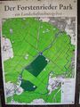
Map of Forstenrieder Park
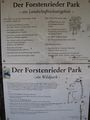
Information and Warnings
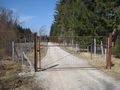
The gate that slowed me
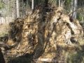
A fallen over tree near the gate
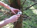
Our improvised contraption to take the obligatory picture of us


The_T-Man
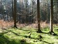
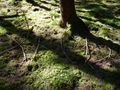
The forest at the approximate point
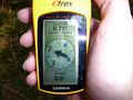
Remaining distance
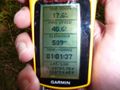
Coordinates displayed at the hashpoint
Us being photographed by the camera on the 100% organic makeshift stand
Marker I prepared while waiting for DerFlob
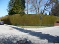
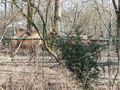
I find this hedge to a) cut off space of the garden and b) be just way too smug
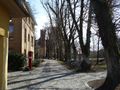
A castle, refurbished to be a youth hostel
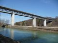
The Großhesselohe railroad bridge across the Isar river on my way back
The view N (you can already see the combustion plant's chimney)
Same view, a bit closer to the city
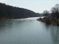
The view back south towards Pullach and the hashpoint
No, they're not indigenous, that's just the zoo at Thalkirchen
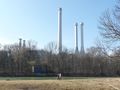
The combustion plant München Süd
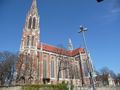
One of München's notable churches in Giesing


Robert
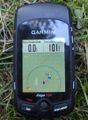
GPS

Somewhere...

