Difference between revisions of "2012-03-21 59 17"
imported>Zeot ([live picture] Picnic in a pitch-black forest in the middle of nowhere [http://www.openstreetmap.org/?lat=59.06260000&lon=17.49110000&zoom=16&layers=B000FTF @59.0626,17.4911]) |
imported>FippeBot m (Location) |
||
| (15 intermediate revisions by 2 users not shown) | |||
| Line 1: | Line 1: | ||
| − | |||
| − | |||
| − | |||
| − | |||
| − | |||
| − | |||
| − | |||
| − | |||
| − | |||
| − | |||
{{meetup graticule | {{meetup graticule | ||
| lat=59 | | lat=59 | ||
| Line 15: | Line 5: | ||
}} | }} | ||
| − | |||
__NOTOC__ | __NOTOC__ | ||
== Location == | == Location == | ||
| − | + | In a forest pretty close to the main road out in the middle of nowhere. | |
== Participants == | == Participants == | ||
| Line 26: | Line 15: | ||
*Anton | *Anton | ||
*Toni | *Toni | ||
| + | *Od | ||
== Plans == | == Plans == | ||
| − | |||
*Taking the commuter train from Stockholm C around 1730 with [[User:Henrik|Henrik]], Toni and Anton -- [[User:Zeot|zeot]] [http://www.openstreetmap.org/?lat=59.31423330&lon=18.05376980&zoom=16&layers=B000FTF @59.3142,18.0538] 17:50, 20 March 2012 (EDT) | *Taking the commuter train from Stockholm C around 1730 with [[User:Henrik|Henrik]], Toni and Anton -- [[User:Zeot|zeot]] [http://www.openstreetmap.org/?lat=59.31423330&lon=18.05376980&zoom=16&layers=B000FTF @59.3142,18.0538] 17:50, 20 March 2012 (EDT) | ||
== Expedition == | == Expedition == | ||
| − | < | + | We were going to meet up outside Åhlens at Skanstull 1700, but I got there a bit early since I had nothing to do at home. I was going for [[Hobbit_achievement|The Hobbit]] and were therefore barefoot, which caused a random girl to approach me and ask the obvious question "Why are you barefoot?". After I had explained it very briefly she said she thought it was awesome, and that she had been looking for similar activities to do in Stockholm (she was new in Sweden). Shortly after she had left, the other people in my party arrived and we could start our journey!<br> |
| − | + | We took the subway to Stockholm C and the commuter train to nowhere from there. Not much happened on the train. We talked about if a week of biking and geohashing would be a good idea and possible locations for this.<br> Since we were heading to the middle of nowhere we had to change trains, and we had like ten seconds to get from the first train to the other, which meant we had to run. This wouldn't normally have been a problem, except that now two of us were barefoot. And running barefoot on a graveled platform is extremely unpleasant. So out feet got very sad, but at least we got on the train in time.<br> | |
| − | + | Once at Mölnbo, we made our first food stop on a sandbox and then we went to the local Kwik-E-Mart and two of us bought supplies for the long journey ahead of us.<br> | |
| − | < | + | Not long after we had started walking, we realized that we couldn't walk on the sidewalk since it was infested by malicious gravel, so we had to walk on the car road. Since we, as mentioned, were in the middle of nowhere, it didn't take long until the street lights disappeared and the road got pitch-black. It didn't feel too safe to walk on a country road, in the dark, clad in dark cloths. But we (spoiler alert) made it there and back again alive, and without losing The Ring! We made a short stop for food again on the side of the road.<br> |
| + | It was both pleasant and unpleasant for the feet when it was time to enter to forest. It was very hard to see where you put your feet and it was cold, but it was nice with a softer groundwork. It only took us about five minutes to reach the hashpoint from the road, and once there we laid out our picnic blanket and brought out the pie and coffee. It felt good to sit for a while, and I drank plenty of coffee since I was pretty much the only one who wanted any, and I had brought a full thermos.<br> | ||
| + | Then we took some pictures of our wonderful picnic, and as you can clearly see; we're all ''extremely'' photogenic.<br> | ||
| + | After that, it was time to go back so that we wouldn't miss our train. After sitting down, it was very painful to walk again but we didn't have much of a choice since we had a train to catch. Or well, I thought we didn't have much of a choice, but Anton told me he crawled the first part... (I wasn't with him then, I was further along with [[User:Henrik|Henrik]] and Toni) | ||
| + | <br> | ||
| + | Anyhow, when we got to the road we pretty much forgot our feet and started playing singing games where you're supposed to come up with songs on a random letter and sing them, and before we knew it we were back at the train station.<br><br> | ||
| + | All together, it was a pretty awesome night and a perfect example for why I love geohashing. We walked about 12km, took an hour long train ride, barefoot. Then we picnicked in the middle of a pitch-black forest. I get the feeling that we wouldn't have done this if it weren't for geohashing...<br><br> | ||
| + | ''("I" and "me" is [[User:zeot|zeot]])'' | ||
== Photos == | == Photos == | ||
| − | |||
| − | |||
| − | |||
<gallery perrow="5"> | <gallery perrow="5"> | ||
| + | Image:2012-03-21_59_17_22-58-41-784.jpg | The ring and [[user:zeot|zeot's]] dirty feet [http://www.openstreetmap.org/?lat=59.06440000&lon=17.50410000&zoom=16&layers=B000FTF @59.0644,17.5041] | ||
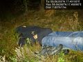
| − | Image:2012-03- | + | Image:2012-03-21_59_17_23-01-27-083.jpg | Picnic in a pitch-black forest in the middle of nowhere [http://www.openstreetmap.org/?lat=59.06260000&lon=17.49110000&zoom=16&layers=B000FTF @59.0626,17.4911] |
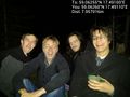
| − | Image:2012-03- | + | Image:2012-03-21_59_17_23-02-48-760.jpg | Henrik was tired after the long walk [http://www.openstreetmap.org/?lat=59.06260000&lon=17.49090000&zoom=16&layers=B000FTF @59.0626,17.4909] |
| + | |||
| + | Image:2012-03-21_59_17_23-10-27-287.jpg | On the commuter train to nowhere [http://www.openstreetmap.org/?lat=59.23440000&lon=17.97590000&zoom=16&layers=B000FTF @59.2344,17.9759] | ||
| + | |||
| + | Image:2012-03-21_59_17_23-11-24-075.jpg | Food stop #1 [http://www.openstreetmap.org/?lat=59.04510000&lon=17.41160000&zoom=16&layers=B000FTF @59.0451,17.4116] | ||
| + | |||
| + | Image:2012-03-21_59_17_23-13-32-243.jpg | Food stop #2 [http://www.openstreetmap.org/?lat=59.05490000&lon=17.45990000&zoom=16&layers=B000FTF @59.0549,17.4599] | ||
| − | Image:2012-03-21_59_17_23- | + | Image:2012-03-21_59_17_23-16-28-306.jpg | Picnic [http://www.openstreetmap.org/?lat=59.06260000&lon=17.49110000&zoom=16&layers=B000FTF @59.0626,17.4911] |
</gallery> | </gallery> | ||
== Achievements == | == Achievements == | ||
{{#vardefine:ribbonwidth|800px}} | {{#vardefine:ribbonwidth|800px}} | ||
| − | + | {{Picnic_geohash | |
| + | | latitude = 59 | ||
| + | | longitude = 17 | ||
| + | | date = 2012-03-21 | ||
| + | | name = [[User:zeot|zeot]], [[User:Henrik|Henrik]], Anton, Toni and Od | ||
| + | | food = Pie, apples and drinking coffee | ||
| + | }} | ||
| + | {{Hobbit achievement | ||
| + | | latitude = 59 | ||
| + | | longitude = 17 | ||
| + | | date = 2012-03-21 | ||
| + | | pronoun = their | ||
| + | | name = [[User:zeot|zeot]] and Anton | ||
| + | }} | ||
| + | {{drag-along | ||
| + | | latitude = 59 | ||
| + | | longitude = 17 | ||
| + | | date = 2012-03-21 | ||
| + | | partner = Od | ||
| + | | name =[[User:zeot|zeot]] and [[User:Henrik|Henrik]] | ||
| + | }} | ||
| + | {{Public transport geohash | ||
| + | | latitude = 59 | ||
| + | | longitude = 17 | ||
| + | | date = 2012-03-21 | ||
| + | | busline = 37 Gnesta | ||
| + | | name = [[User:zeot|zeot]], [[User:Henrik|Henrik]], Anton, Toni and Od | ||
| + | }} | ||
| + | {{pie | ||
| + | | latitude = 59 | ||
| + | | longitude = 17 | ||
| + | | date = 2012-03-21 | ||
| + | | name = [[User:zeot|zeot]] | ||
| + | | pastry = spinach and feta cheese pie | ||
| + | }} | ||
| + | {{land geohash | ||
| + | | latitude = 59 | ||
| + | | longitude = 17 | ||
| + | | date = 2012-03-21 | ||
| + | | name = [[User:zeot|zeot]], [[user:Henrik|Henrik]], Anton, Toni and Od | ||
| + | }} | ||
| − | |||
| − | |||
| − | |||
| − | |||
| − | |||
| − | |||
| − | |||
| − | |||
| − | |||
| − | |||
| − | |||
[[Category:Expeditions]] | [[Category:Expeditions]] | ||
| − | |||
[[Category:Expeditions with photos]] | [[Category:Expeditions with photos]] | ||
| − | |||
| − | |||
| − | |||
| − | |||
| − | |||
[[Category:Coordinates reached]] | [[Category:Coordinates reached]] | ||
| − | + | {{location|SE|AB}} | |
| − | |||
| − | |||
| − | |||
| − | |||
| − | |||
| − | |||
| − | |||
| − | |||
| − | |||
Latest revision as of 03:06, 13 August 2019
| Wed 21 Mar 2012 in 59,17: 59.0625513, 17.4909986 geohashing.info google osm bing/os kml crox |
Location
In a forest pretty close to the main road out in the middle of nowhere.
Participants
Plans
- Taking the commuter train from Stockholm C around 1730 with Henrik, Toni and Anton -- zeot @59.3142,18.0538 17:50, 20 March 2012 (EDT)
Expedition
We were going to meet up outside Åhlens at Skanstull 1700, but I got there a bit early since I had nothing to do at home. I was going for The Hobbit and were therefore barefoot, which caused a random girl to approach me and ask the obvious question "Why are you barefoot?". After I had explained it very briefly she said she thought it was awesome, and that she had been looking for similar activities to do in Stockholm (she was new in Sweden). Shortly after she had left, the other people in my party arrived and we could start our journey!
We took the subway to Stockholm C and the commuter train to nowhere from there. Not much happened on the train. We talked about if a week of biking and geohashing would be a good idea and possible locations for this.
Since we were heading to the middle of nowhere we had to change trains, and we had like ten seconds to get from the first train to the other, which meant we had to run. This wouldn't normally have been a problem, except that now two of us were barefoot. And running barefoot on a graveled platform is extremely unpleasant. So out feet got very sad, but at least we got on the train in time.
Once at Mölnbo, we made our first food stop on a sandbox and then we went to the local Kwik-E-Mart and two of us bought supplies for the long journey ahead of us.
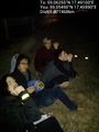
Not long after we had started walking, we realized that we couldn't walk on the sidewalk since it was infested by malicious gravel, so we had to walk on the car road. Since we, as mentioned, were in the middle of nowhere, it didn't take long until the street lights disappeared and the road got pitch-black. It didn't feel too safe to walk on a country road, in the dark, clad in dark cloths. But we (spoiler alert) made it there and back again alive, and without losing The Ring! We made a short stop for food again on the side of the road.
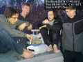
It was both pleasant and unpleasant for the feet when it was time to enter to forest. It was very hard to see where you put your feet and it was cold, but it was nice with a softer groundwork. It only took us about five minutes to reach the hashpoint from the road, and once there we laid out our picnic blanket and brought out the pie and coffee. It felt good to sit for a while, and I drank plenty of coffee since I was pretty much the only one who wanted any, and I had brought a full thermos.
Then we took some pictures of our wonderful picnic, and as you can clearly see; we're all extremely photogenic.
After that, it was time to go back so that we wouldn't miss our train. After sitting down, it was very painful to walk again but we didn't have much of a choice since we had a train to catch. Or well, I thought we didn't have much of a choice, but Anton told me he crawled the first part... (I wasn't with him then, I was further along with Henrik and Toni)
Anyhow, when we got to the road we pretty much forgot our feet and started playing singing games where you're supposed to come up with songs on a random letter and sing them, and before we knew it we were back at the train station.
All together, it was a pretty awesome night and a perfect example for why I love geohashing. We walked about 12km, took an hour long train ride, barefoot. Then we picnicked in the middle of a pitch-black forest. I get the feeling that we wouldn't have done this if it weren't for geohashing...
("I" and "me" is zeot)
Photos
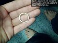
The ring and zeot's dirty feet @59.0644,17.5041
Picnic in a pitch-black forest in the middle of nowhere @59.0626,17.4911
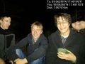
Henrik was tired after the long walk @59.0626,17.4909
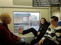
On the commuter train to nowhere @59.2344,17.9759
Food stop #1 @59.0451,17.4116
Food stop #2 @59.0549,17.4599
Picnic @59.0626,17.4911


Achievements
zeot, Henrik, Anton, Toni and Od earned the Picnic achievement
|
zeot and Anton earned the Hobbit Achievement
|
zeot and Henrik earned the Drag-along achievement
|
zeot, Henrik, Anton, Toni and Od earned the Public transport geohash achievement
|
zeot earned the Pie Geohash Achievement
|
zeot, Henrik, Anton, Toni and Od earned the Land geohash achievement
|