Difference between revisions of "2012-03-28 48 11"
imported>The T-Man (→Plans) |
imported>DerFlob (yesterday's hash report) |
||
| Line 29: | Line 29: | ||
== Expedition == | == Expedition == | ||
| − | |||
| − | == | + | === [[User:DerFlob|DerFlob]] === |
| − | |||
| + | I started my bike ride at about 2 p.m. I estimated that it will take about 90 minutes, but I wanted a bit of spare time so I wouldn't be late, because I haven't been cycling that far for a long time and maybe only a hand full of times overall. For routing I used a track calculated at OpenCycleMap.org, which I put on my new Garmin eTrex 20, that has been delivered the same morning. | ||
| + | At first I didn't follow the recommended track, because it would have routed me through München's pedestrian area, which probably would have been quite crowded. Instead I crossed the Isar river a bit to the north at the Friedensengel and got back on track thereafter. After driving through München's [http://en.wikipedia.org/wiki/Olympiapark,_Munich Olympiapark], the ride was rather unspectacular, mostly following a highway alongside towards Karlsfeld. After arriving at the hashpoint and taking some pictures, I still had some time, before [[User:The_T-Man|The_T-Man]] wanted to arrive, so I headed towards the suburban train station of Karlsfeld, where I waited a few minutes for him to arrive. After heading back to the point, taking some additional pictures, we parted at the train station, from where I started my ride home. | ||
| + | This time I drove through München's center and pedestrian area, which, as expected, turned out to be a mistake, due to it being quite crowded and some evening rush hour traffic. Thus, it took me a good 2 hours to get back home, which can also be contributed to me being quite exhausted. In the end I cycled about 50km. | ||
| + | |||
| + | === [[User:The_T-Man|The_T-Man]] === | ||
| + | |||
| + | <!--== Tracklog == | ||
| + | if your GPS device keeps a log, you may post a link here | ||
| + | maybe to follow -~~~~ | ||
| + | --> | ||
== Photos == | == Photos == | ||
| − | < | + | |
| − | Image: | + | === [[User:DerFlob|DerFlob]] === |
| − | --> | + | |
| + | <gallery perrow="5"> | ||
| + | Image:2012-03-28 48 11 Flob 01.jpg | Proof 1 | ||
| + | Image:2012-03-28 48 11 Flob 02.jpg | Proof 2 | ||
| + | Image:2012-03-28 48 11 Flob 03.jpg | Hash is on this piece of grass | ||
| + | Image:2012-03-28 48 11 Flob 04.jpg | Olympiaturm to the left and parts of Olympiahalle to the right | ||
| + | </gallery> | ||
| + | |||
| + | === [[User:The_T-Man|The_T-Man]] === | ||
| + | |||
<gallery perrow="5"> | <gallery perrow="5"> | ||
</gallery> | </gallery> | ||
| + | |||
== Achievements == | == Achievements == | ||
| Line 45: | Line 63: | ||
<!-- Add any achievement ribbons you earned below, or remove this section --> | <!-- Add any achievement ribbons you earned below, or remove this section --> | ||
| − | |||
| − | |||
| − | |||
| − | |||
| − | |||
| − | |||
| − | |||
| − | |||
[[Category:Expeditions]] | [[Category:Expeditions]] | ||
| − | + | [[Category:Expeditions with photos]] | |
| − | [[Category:Expeditions with photos]] | ||
| − | |||
| − | |||
| − | |||
| − | |||
| − | |||
[[Category:Coordinates reached]] | [[Category:Coordinates reached]] | ||
| − | |||
| − | |||
| − | |||
| − | |||
| − | |||
| − | |||
| − | |||
| − | |||
| − | |||
| − | |||
Revision as of 11:31, 29 March 2012
| Wed 28 Mar 2012 in 48,11: 48.2292002, 11.4668425 geohashing.info google osm bing/os kml crox |
Location
On Lessingstraße in Karlsfeld N of München
Participants
Plans
I'm planning to go there by bike. Probably in the afternoon, between 3 and 4 p.m. But I'm open for other time suggestions. -DerFlob 11:25, 27 March 2012 (EDT)
- I'll buy myself a day-ticket tomorrow. Cycling is out of question, since I caught Scherzkeks' cold. Probably going there after university, which ends at about 12:00 at Martinsried. From there I'll go to Karlsfeld via S-Bahn. -The T-Man 14:37, 27 March 2012 (EDT)
Expedition
DerFlob
I started my bike ride at about 2 p.m. I estimated that it will take about 90 minutes, but I wanted a bit of spare time so I wouldn't be late, because I haven't been cycling that far for a long time and maybe only a hand full of times overall. For routing I used a track calculated at OpenCycleMap.org, which I put on my new Garmin eTrex 20, that has been delivered the same morning. At first I didn't follow the recommended track, because it would have routed me through München's pedestrian area, which probably would have been quite crowded. Instead I crossed the Isar river a bit to the north at the Friedensengel and got back on track thereafter. After driving through München's Olympiapark, the ride was rather unspectacular, mostly following a highway alongside towards Karlsfeld. After arriving at the hashpoint and taking some pictures, I still had some time, before The_T-Man wanted to arrive, so I headed towards the suburban train station of Karlsfeld, where I waited a few minutes for him to arrive. After heading back to the point, taking some additional pictures, we parted at the train station, from where I started my ride home. This time I drove through München's center and pedestrian area, which, as expected, turned out to be a mistake, due to it being quite crowded and some evening rush hour traffic. Thus, it took me a good 2 hours to get back home, which can also be contributed to me being quite exhausted. In the end I cycled about 50km.
The_T-Man
Photos
DerFlob
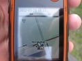
Proof 1
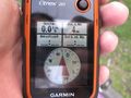
Proof 2
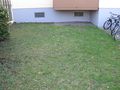
Hash is on this piece of grass
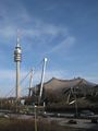
Olympiaturm to the left and parts of Olympiahalle to the right


The_T-Man