Difference between revisions of "2012-04-06 45 -122"
From Geohashing
imported>Michael5000 m (→Photos) |
imported>FippeBot m (Location) |
||
| (4 intermediate revisions by one other user not shown) | |||
| Line 24: | Line 24: | ||
*[[User:Michael5000|Michael5000]] | *[[User:Michael5000|Michael5000]] | ||
| − | *Niece #4 | + | *[[User:Niece4|Niece #4]] |
| − | |||
| − | |||
| − | |||
== Expedition == | == Expedition == | ||
| Line 33: | Line 30: | ||
We wandered through a gate, up a dirt road, and down a very muddy dirt path to the hashpoint. Details.... later, I think. | We wandered through a gate, up a dirt road, and down a very muddy dirt path to the hashpoint. Details.... later, I think. | ||
| − | + | 2019-03-28 Update: I guess I never got to those details. I don't really remember this one now. Geez, N#4 is a LITTLE KID in that picture... | |
| − | |||
== Photos == | == Photos == | ||
| Line 46: | Line 42: | ||
<!-- Add any achievement ribbons you earned below, or remove this section --> | <!-- Add any achievement ribbons you earned below, or remove this section --> | ||
| + | {{Multihash2 | count = 2 | date = 2010-04-06 | name = [[User:Michael5000|Michael5000]] and Niece #4 }} | ||
| − | |||
| − | |||
| − | |||
| − | |||
| − | |||
| − | |||
| − | |||
| − | |||
| − | |||
| − | |||
[[Category:Expeditions]] | [[Category:Expeditions]] | ||
| − | |||
[[Category:Expeditions with photos]] | [[Category:Expeditions with photos]] | ||
| − | |||
| − | |||
| − | |||
| − | |||
| − | |||
[[Category:Coordinates reached]] | [[Category:Coordinates reached]] | ||
| − | + | {{location|US|WA|CR}} | |
| − | |||
| − | |||
| − | |||
| − | |||
| − | |||
| − | |||
| − | |||
| − | |||
| − | |||
Latest revision as of 03:22, 13 August 2019
| Fri 6 Apr 2012 in 45,-122: 45.8083156, -122.5005609 geohashing.info google osm bing/os kml crox |
Location
On a horse trail northeast of Battle Ground, Washington.
Participants
Expedition
We wandered through a gate, up a dirt road, and down a very muddy dirt path to the hashpoint. Details.... later, I think.
2019-03-28 Update: I guess I never got to those details. I don't really remember this one now. Geez, N#4 is a LITTLE KID in that picture...
Photos
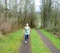
Niece #4 comes running.

Achievements
Michael5000 and Niece #4 earned the Multihash Achievement
|